List of mountain and hill ranges in Germany

Last updated

The Hochkonig in the Berchtesgaden Alps Hochkoenig.jpg
The Hochkönig in the Berchtesgaden Alps

This list of mountain and hill ranges in Germany contains a selection of the main mountain and hill regions in Germany.

In addition the list shows the highest (German) mountain in the range together with its height above sea level (taken as Normalnull (NN)) and the state in which its highest elevation is located. If the highest feature extends into neighbouring states, it is possible, that there are higher summits located there.

The same hill or mountain may be listed more than once; for example the Zugspitze, Germany’s highest mountain, belongs to the Alps, the Bavarian Alps, the Northern Limestone Alps and the Wetterstein Mountains.

The ranges are listed in alphabetical order.

Mountain or hill rangeHighest peakHeight above NN State
mft
Adelegg Schwarzer Grat 1,1183,668 Baden-Württemberg
Ahlsburg Sackberg411.41,350 Lower Saxony
Ahr Hills Aremberg 6232,044 Rhineland-Palatinate
Allgäu Alps Hochfrottspitze 2,6498,691 Bavaria
Alps Zugspitze 2,9629,718 Bavaria
Altdorf Forest unnamed summit7772,549 Baden-Württemberg
Amtsberge Belzer Berg392.21,287 Lower Saxony
Ankum Heights Trillenberg140460 Lower Saxony
Arnsberg Forest unnamed summit581.31,907 North Rhine-Westphalia
Atzenberg Heights unnamed summit7072,320 Baden-Württemberg
Baumberge Westerberg 187614 North Rhine-Westphalia
Bavarian Alps Zugspitze 2,9629,718 Bavaria
Bavarian Forest Großer Arber 1,4564,777 Bavaria
Beckum Hills Mackenberg173568 North Rhine-Westphalia
Berchtesgaden Alps Watzmann 2,7138,901 Bavaria
Bergstraße Melibokus 5171,696 Hesse
Bergisches Land Homert 5191,703 North Rhine-Westphalia
Bingen Forest Kandrich 6372,090 Rhineland-Palatinate
Black Forest Feldberg 1,4934,898 Baden-Württemberg
Bleicherode Hills Ziegenrück460.81,512 Thuringia
Blauberge Halserspitz1,862.86,112 Bavaria
Borkenberge Fischberg134440 North Rhine-Westphalia
Bramwald Totenberg 4081,339 Lower Saxony
Brohmer Berge unnamed elevation near Matzdorf152.9502 Mecklenburg-Vorpommern
Bückeberg Bückeberg 3671,204 Lower Saxony
Burgberg Großer Everstein345.21,133 Lower Saxony
Burgwald Knebelsrod 4431,453 Hesse
Chiemgau Alps Sonntagshorn 1,9616,434 Bavaria
Damme Hills Signalberg 146479 Lower Saxony
Deister Bröhn 4051,329 Lower Saxony
Berge Tannenbültenberg104341 North Rhine-Westphalia
Dinkelberg Hohe Flum 5351,755 Baden-Württemberg
Dollberge Dollberg 6952,280 Rhineland-Palatinate, Saarland
Dransfeld Municipal Forest Hoher Hagen 5081,667 Lower Saxony
Drawehn Hoher Mechtin 142466 Lower Saxony
Dresden Heath Dachsenberg281922 Saxony
Duinger Berg Babenstein 3311,086 Lower Saxony
Dün Rondel5221,713 Thuringia
Eastern Ore Mountains Kahleberg 9052,969 Saxony
Ebbe Mountains Nordhelle 6632,175 North Rhine-Westphalia
Egge Hills Preußischer Velmerstot 4681,535 North Rhine-Westphalia
Eifel Hohe Acht 7472,451 Rhineland-Palatinate
Elbe Sandstone Mountains Großer Zschirnstein 5621,844 Saxony
Elfas Helleberg4101,350 Lower Saxony
Ellensen Forest Scharfenberg3421,122 Lower Saxony
Ellwangen Hills Hohenberg & Schönberg 5691,867 Baden-Württemberg
Elster Mountains Hoher Brand 8052,641 Saxony
Ester Mountains Krottenkopf 2,0866,844 Bavaria
Fahner Heights Abtsberg4131,355 Thuringia
Fichtel Mountains Schneeberg 1,0533,455 Bavaria
Finne Künzelsberg3801,250 Thuringia
Franconian Forest Döbraberg 7942,605 Bavaria, Thuringia
Franconian Heights Hornberg 5541,818 Bavaria
Fläming Heath Hagelberg 200.2657 Brandenburg
Gatterberge 6232,044 Bavaria
Gleichberge Großer Gleichberg 6792,228 Thuringia
Giesen Hills 162.6533 Lower Saxony
Göttingen Forest Mackenröder Spitze 427.51,403 Lower Saxony
Gröden Hills Heidehöhe 201.4661 Brandenburg
Großer Heuberg Lemberg 1,0153,330 Baden-Württemberg
Haarstrang Spitze Warte 3891,276 North Rhine-Westphalia
Habichtswald Hohes Gras 614.72,017 Hesse
Hahnenkamm Hesselberg 6892,260 Bavaria
Hainberg Kalter Buschkopf299981 Lower Saxony
Hainich Alter Berg4941,621 Thuringia
Hainleite 4641,522 Thuringia
Harburg Hills Hülsenberg155509 Lower Saxony
Harly Forest Harlyberg 256840 Lower Saxony
Harplage 290950 Lower Saxony
Harrl Harrlberg 211692 Lower Saxony
Harz Brocken 1,141.13,744 Lower Saxony, Saxony-Anhalt, Thuringia
Haßberge Nassacher Höhe 512.21,680 Bavaria
Heber Mechtshäuser Berg3141,030 Lower Saxony
Heilingen Heights 3681,207 Thuringia
Hellberge Langer Berg159.9525 Saxony-Anhalt
Helpt Hills Helpter Berg179587 Mecklenburg-Vorpommern
Hemberg Hundskopf 4711,545 Hesse
Hessisches Kegelspiel Stallberg5531,814 Hesse
Hildesheim Forest Griesberg 358.91,177 Lower Saxony
Hils Bloße Zelle 480.41,576 Lower Saxony
Hochgeländ unnamed summit6782,224 Baden-Württemberg
Högl Högl 8272,713 Bavaria
Hohe Mark Waldbeerenberg146479 North Rhine-Westphalia
Hoher Meißner Kasseler Kuppe 753.62,472 Hesse
Hohe Schrecke Schulzenberg3201,050 Thuringia
Holstein Switzerland Bungsberg 168551 Schleswig-Holstein
Holzberg Holzberg444.51,458 Lower Saxony
Homburg Forest 406.11,332 Lower Saxony
Hörselberge Großer Hörselberg 4841,588 Thuringia
Hube Fuchshöhlenberg3461,135 Lower Saxony
Hümmling Windberg73240 Lower Saxony
Hunsrück Erbeskopf 8162,677 Rhineland-Palatinate
Hütten Hills Scheelsberg 106348 Schleswig-Holstein
Huy Buchenberg 3141,030 Saxony-Anhalt
Idar Forest An den zwei Steinen/Kahlheid 7662,513 Rhineland-Palatinate
Innerste Uplands Griesberg 358.91,177 Lower Saxony
Ith Lauensteiner Kopf 4391,440 Lower Saxony
Kaiserstuhl Totenkopf 5571,827 Baden-Württemberg
Karwendel Östliche Karwendelspitze 2,5378,323 Bavaria
Kaufungen Forest Bilstein 641.22,104 Hesse
Kellenberg Kellenberg77253 Lower Saxony
Kellerwald Wüstegarten 6752,215 Hesse
Kiffing Heuberg344.11,129 Hesse
Kleiner Deister Wolfsköpfe345.71,134 Lower Saxony
Knüll Eisenberg 6362,087 Hesse
Königshain Hills Ahlberg4111,348 Saxony
Kühlung Diedrichshagener Berg 129.7426 Mecklenburg-Vorpommern
Külf 260850 Lower Saxony
Kyffhäuser Kulpenberg 4771,565 Thuringia
Lahnberge Ortenberg3801,250 Hesse
Landrücken Frauenstein 5961,955 Hesse
Lange Berge Buchberg 5281,732 Bavaria
Lusatian Highlands Valtenberg 586.61,925 Saxony
Laußnitz Heath Hinterer Buchberg 245804 Saxony
Latten Mountains Karkopf 1,7385,702 Bavaria
Leine Uplands Bloße Zelle 480.41,576 Lower Saxony
Lenne Mountains Homert 6562,152 North Rhine-Westphalia
Lichtenberge Adlershorst254.2834 Lower Saxony
Limpurg Hills Altenberg 564.71,853 Baden-Württemberg
Lingen Heights Windmühlenberg91299 Lower Saxony
Lippe Uplands Köterberg 4961,627 Lower Saxony, North Rhine-Westphalia
Little Thuringian Forest Schneeberg 6922,270 Thuringia
Löwenstein Hills Stocksberg 538.91,768 Baden-Württemberg
Lüneburg Heath Wilseder Berg 169.2555 Lower Saxony
Lützelsoon Womrather Höhe 5971,959 Rhineland-Palatinate
Mainhardt Forest Hohe Brach 5861,923 Baden-Württemberg
Marburg Hills Vogelheerd369.81,213 Hesse
Märkisch Switzerland Krugberg 129423 Brandenburg
Melle Hills Diedrichsburg 218715 Lower Saxony
Moselberge unnamed summit4341,424 Rhineland-Palatinate
Müggelberge Großer Müggelberg115.4379 Berlin
Murrhardt Forest Wüstenberg5441,785 Baden-Württemberg
Muskauer Faltenbogen Hoher Berg183600 Brandenburg, Saxony
Muskau Heath 169554 Saxony
Nesselberg Grasberg3751,230 Lower Saxony
Northern Limestone Alps Zugspitze 2,9629,718 Bavaria
North Palatine Highland Donnersberg 6872,254 Rhineland-Palatinate
Upper Palatinate Forest Gibacht 9383,077 Bavaria
Odenwald Katzenbuckel 6262,054 Baden-Württemberg
Oderwald Hungerberg205673 Lower Saxony
Ohm Hills Birkenberg 533.41,750 Thuringia
Ore Mountains Fichtelberg 1,2153,986 Saxony
Osburger Hochwald Rösterkopf 7082,323 Rhineland-Palatinate
Osterwald Fast4191,375 Lower Saxony
Palatinate Forest Kalmit 6732,208 Rhineland-Palatinate
Rammert Hohwacht5901,940 Baden-Württemberg
Rauen Hills 153502 Brandenburg
Rehburg Hills Brunnenberg 161528 Lower Saxony
Reinhardswald Staufenberg 472.21,549 Hesse
Reinsberge Reinsburg6041,982 Thuringia
Richelsdorf Hills Herzberg 478.21,569 Hesse
Rhön Wasserkuppe 950.23,117 Hesse
Rotenberg Rotenberg317.31,041 Lower Saxony
Rothaar Mountains Langenberg 843.22,766 Hesse, North Rhine-Westphalia
Saxon Switzerland Großer Zschirnstein 5611,841 Saxony
Saalhausen Hills Himberg 687.72,256 North Rhine-Westphalia
Sackwald Ahrensberg 3741,227 Lower Saxony
Salzgitter Hills Vier Berge322.91,059 Lower Saxony
Schelderwald Angelburg 6091,998 Hesse
Schlierbach Forest Rabenkuppe 5151,690 Hesse
Schmücke Scharfer Berg249817 Thuringia
Schönbuch Bromberg5831,913 Baden-Württemberg
Schurwald Kernen 513.21,684 Baden-Württemberg
Swabian Jura Lemberg 1,0153,330 Baden-Württemberg
Schwarzwälder Hochwald Erbeskopf 8162,677 Rhineland-Palatinate, Saarland
Selter Hohe Egge3951,296 Lower Saxony
Seulingswald Toter Mann 4801,570 Hesse
Sieben Berge Hohe Tafel 3951,296 Lower Saxony
Siebengebirge Großer Ölberg 460.11,510 North Rhine-Westphalia
Solling Große Blöße 5281,732 Lower Saxony
Söhre Hirschberg 643.42,111 Hesse
Soonwald Ellerspring 6572,156 Rhineland-Palatinate
Spaar Hills Juchhöh192630 Saxony
Spessart Geiersberg 5861,923 Bavaria
Stemweder Berg Scharfer Berg 181594 North Rhine-Westphalia and Lower Saxony
Stölzingen Hills Eisberg 5831,913 Hesse
Stromberg Baiselberg 4771,565 Baden-Württemberg
Süntel Hohe Egge437.51,435 Lower Saxony
Süchtelner Höhe 90.7298 North Rhine-Westphalia
Taunus Großer Feldberg 878.52,882 Hesse
Teutoburg Forest Barnacken 4461,463 North Rhine-Westphalia
Thuringian Highland Großer Farmdenkopf 8692,851 Thuringia
Thuringian Forest Großer Beerberg 982.93,225 Thuringia
Ville Glessener Höhe 204669 North Rhine-Westphalia
Virngrund Hornberg 5801,900 Baden-Württemberg
Vogelsberg Taufstein 7732,536 Hesse
Vogler Ebersnacken 460.41,510 Lower Saxony
Vorberge Hainberg3531,158 Lower Saxony
Vorholz Knebelberg243797 Lower Saxony
Waldeck Forest Weidelsberg 4921,614 Hesse
Waldenburg Hills Mühlberg 5231,716 Baden-Württemberg
Welzheim Forest Hagberg 5851,919 Baden-Württemberg
Weper Balos3791,243 Lower Saxony
Westerwald Fuchskaute 6572,156 Rhineland-Palatinate
Weser Uplands Große Blöße 5281,732 Lower Saxony
Weser Hills Hohenstein3301,080 Lower Saxony
Wetterstein Zugspitze 2,9629,718 Bavaria
Wiehen Hills Heidbrink 3201,050 North Rhine-Westphalia
Wieren Hills Hoher Berg 137449 Lower Saxony
Windleite Zimmerberg3741,227 Thuringia
Wingst Silberberg 74243 Lower Saxony
Zittau Mountains Lausche 7932,602 Saxony
Zitter Forest Weißer Stein 6892,260 Saxony

See also


Related Research Articles

<span class="mw-page-title-main">Geography of Switzerland</span>

The geography of Switzerland features a mountainous and landlocked country located in Western and Central Europe. Switzerland's natural landscape is marked by its numerous lakes and mountains. It is surrounded by five countries: Austria and Liechtenstein to the east, France to the west, Italy to the south and Germany to the north. Switzerland has a maximum north–south length of 220 kilometres (140 mi) and an east–west length of about 350 kilometres (220 mi).

<span class="mw-page-title-main">Swiss Alps</span> Portion of the Alps that lies within Switzerland

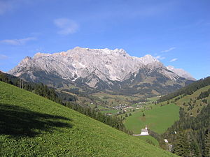
The Alpine region of Switzerland, conventionally referred to as the Swiss Alps, represents a major natural feature of the country and is, along with the Swiss Plateau and the Swiss portion of the Jura Mountains, one of its three main physiographic regions. The Swiss Alps extend over both the Western Alps and the Eastern Alps, encompassing an area sometimes called Central Alps. While the northern ranges from the Bernese Alps to the Appenzell Alps are entirely in Switzerland, the southern ranges from the Mont Blanc massif to the Bernina massif are shared with other countries such as France, Italy, Austria and Liechtenstein.

<span class="mw-page-title-main">Bernese Alps</span> Part of the Alps mountain range in Switzerland

The Bernese Alps are a mountain range of the Alps, located in western Switzerland. Although the name suggests that they are located in the Berner Oberland region of the canton of Bern, portions of the Bernese Alps are in the adjacent cantons of Valais, Fribourg and Vaud, the latter being usually named Fribourg Alps and Vaud Alps respectively. The highest mountain in the range, the Finsteraarhorn, is also the highest point in the canton of Bern.

<span class="mw-page-title-main">Julian Alps</span> Mountain range of the Southern Limestone Alps in northeastern Italy and Slovenia

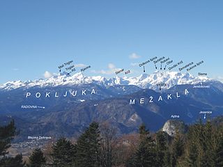
The Julian Alps are a mountain range of the Southern Limestone Alps that stretch from northeastern Italy to Slovenia, where they rise to 2,864 m at Mount Triglav, the highest peak in Slovenia. A large part of the Julian Alps is included in Triglav National Park. The second highest peak of the range, the 2,755 m high Jôf di Montasio, lies in Italy.

<span class="mw-page-title-main">Kamnik–Savinja Alps</span> Mountain range in Slovenia and Austria

The Kamnik–Savinja Alps are a mountain range of the Southern Limestone Alps. They lie in northern Slovenia, except for the northernmost part, which lies in Austria.

<span class="mw-page-title-main">Australian Alps</span> Bioregion in Australia

The Australian Alps are a mountain range in southeast Australia. The range comprises an interim Australian bioregion, and is the highest mountain range in Australia. The range straddles the borders of eastern Victoria, southeastern New South Wales, and the Australian Capital Territory. It contains Australia's only peaks exceeding 2,000 m (6,600 ft) in elevation, and is the only bioregion on the Australian mainland in which deep snow falls annually. The range comprises an area of 1,232,981 ha.

<span class="mw-page-title-main">Bavarian Alps</span> Series of mountain ranges in the German state of Bavaria

The Bavarian Alps is a collective name for several mountain ranges of the Northern Limestone Alps within the German state of Bavaria.

<span class="mw-page-title-main">Stubai Alps</span> Mountain range in Central Europe

The Stubai Alps is a mountain range in the Central Eastern Alps of Europe. It derives its name from the Stubaital valley to its east and is located southwest of Innsbruck, Austria. Several peaks form the border between Austria and Italy. The range is bounded by the Inn River valley to the north; the Sill River valley (Wipptal) and the Brenner Pass to the east ; the Ötztal and Timmelsjoch to the west, and to the south by tributaries of the Passer River and Eisack.

<span class="mw-page-title-main">Central Eastern Alps</span> Portion of the Eastern Alps mountain range through Austria and parts of surrounding countries

The Central Eastern Alps, also referred to as Austrian Central Alps or just Central Alps, comprise the main chain of the Eastern Alps in Austria and the adjacent regions of Switzerland, Liechtenstein, Italy and Slovenia. South them is the Southern Limestone Alps.

<span class="mw-page-title-main">Monte Rosa</span> Massif in Switzerland and Italy

Monte Rosa is a mountain massif in the eastern part of the Pennine Alps, on the border between Italy and Switzerland (Valais). The highest peak of the massif, amongst several peaks of over 4.000 m, is the Dufourspitze, the second highest mountain in the Alps and western Europe, after Mont Blanc. The east face of the Monte Rosa towards Italy has a height of about 2.400 meters and is the highest mountain wall of the Alps.

<span class="mw-page-title-main">Allgäu Alps</span> Mountain range in the Northern Limestone Alps

The Allgäu Alps are a mountain range in the Northern Limestone Alps, located in Bavaria and Baden-Württemberg in Germany and Tyrol and Vorarlberg in Austria. The range lies directly east of Lake Constance.

The Upper Rhine Plain, Rhine Rift Valley or Upper Rhine Graben is a major rift, about 350-kilometre-long (220 mi) and on average 50-kilometre-wide (31 mi), between Basel in the south and the cities of Frankfurt/Wiesbaden in the north. Its southern section straddles the France–Germany border. It forms part of the European Cenozoic Rift System, which extends across Central Europe. The Upper Rhine Graben formed during the Oligocene, as a response to the evolution of the Alps to the south. It remains active to the present day. Today, the Rhine Rift Valley forms a downfaulted trough through which the river Rhine flows.

<i>Mittelgebirge</i> Type of low mountain range or hill country common in central Europe

A Mittelgebirge is a type of relatively low mountain range or highland area typical of the geography of central Europe, especially central and southern Germany; it refers to something between rolling low hill country or Hügelland and a proper mountain range like the High Alps.

<span class="mw-page-title-main">Gurktal Alps</span> Mountain range in the Central Eastern Alps in Austria

The Gurktal Alps is a mountain range in the Central Eastern Alps in Austria which is named after the valley of the Gurk river. The range stretches west to Lake Millstatt and east to Neumarkter Sattel. The highest peak is Eisenhut at 2,441m .

Lists of mountains can be organized by continent and more specifically by country and province/state: