This list of mountains and hills of Saxony shows a selection of high and well-known mountains and hills in the German state of Saxony (in order of elevation):
| Name | Height above sea level (NHN) | Natural regions | Remarks | Image |
|---|---|---|---|---|
| Fichtelberg | 1,215 m | Western Ore Mountains | 2 km northwest of Oberwiesenthal, highest mountain in Saxony | 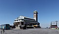 |
| Eisenberg | 1,028 m | Western Ore Mountains | 3 km north of Oberwiesenthal | |
| Auersberg | 1,019 m | Western Ore Mountains | 1 km east of Wildenthal |  |
| Scheffelsberg | 980 m | Western Ore Mountains | 1 km south of Jugel | |
| Schneehübel | 974 m | Western Ore Mountains | 1 km southwest of Carlsfeld | 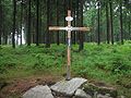 |
| Brückenberg | 964 m | Western Ore Mountains | 1 km west of Wildenthal |  |
| Stangenhöhe | 964 m | Western Ore Mountains | 3 km south of Carlsfeld the summit, at 965 metres, lies in the Czech Republic | |
| Großer Rammelsberg | 963 m | Western Ore Mountains | 3 km east of Mühlleithen | |
| Buchkamm | 951 m | Western Ore Mountains | 3 south of Oberwildenthal | |
| Kiel | 942 m | Western Ore Mountains | north of Klingenthal | |
| Rehhübel | 932 m | Western Ore Mountains | 3 km west of Johanngeorgenstadt | |
| Riesenberg | 923 m | Western Ore Mountains | 3 km northwest of Johanngeorgenstadt | |
| Aschberg | 917 m | Western Ore Mountains | in Klingenthal the summit, at 936 metres, lies in Czech side | |
| Rabenberg | 913 m | Western Ore Mountains | 3 km northeast of Johanngeorgenstadt | |
| Kahleberg | 905 m | Eastern Ore Mountains | 3 km southwest of Altenberg |  |
| Bärenstein | 897 m | Western Ore Mountains | 2 km north of Bärenstein |  |
| Kleiner Lugstein | 896 m | Eastern Ore Mountains | south of Altenberg | |
| Fastenberg | 891 m | Western Ore Mountains | in Johanngeorgenstadt | |
| Hirtstein | 888 m | Central Ore Mountains | 3 km southwest of Reitzenhain |  |
| Schöne Aussicht | 883 m | Western Ore Mountains | 1 km south of Wildenthal | |
| Leistnerhübel | 879 m | Western Ore Mountains | 1 km south of Wildenthal | |
| Eselsberg | 867 m | Western Ore Mountains | 2 km west of Erlabrunn | |
| Ochsenkopf | 836 m | Western Ore Mountains | 1 km east of Rittersgrün | |
| Hundsmarter | 848 m | Western Ore Mountains | 2 km south of Raschau-Markersbach | |
| Hemmschuh | 846 m | Eastern Ore Mountains | south of Rehefeld-Zaunhaus | |
| Ahornberg | 833 m | Central Ore Mountains | 2 km southeast of the Ortsteil Heidelberg (Seiffen) | |
| Pöhlberg | 831 m | Western Ore Mountains | 1 km east of Annaberg-Buchholz | |
| Ochsenkopf | 823 m | Western Ore Mountains | 7 km southwest of Schwarzenberg/Erzgeb. | |
| Geisingberg | 824 m | Eastern Ore Mountains | 2 km northwest of Geising |  |
| Steinhübel | 816 m | Central Ore Mountains | 7 km southwest of Olbernhau | |
| Morgenleithe | 811 m | Western Ore Mountains | 5 km southwest of Schwarzenberg | |
| Scheibenberg | 807 m | Western Ore Mountains | 1 km south of Scheibenberg |  |
| Traugotthöhe | 806 m | Eastern Ore Mountains | southwest of Fürstenau | |
| Steinkuppe | 806 m | Eastern Ore Mountains | in Holzhau | |
| Drachenkopf | 805 m | Eastern Ore Mountains | 1 km southeast of Nassau | |
| Schickelshöhe | 805 m | Eastern Ore Mountains | south of Hermsdorf/Erzgeb. | |
| Hoher Brand | 805 m | Western Ore Mountains | 5 km west of Klingenthal |  |
| Schwarzberg | 802 m | Vogtland | east of Klingenthal | |
| Sauberg | 797 m | Western Ore Mountains | 1 km southwest of Breitenbrunn/Erzgeb. | |
| Kuhberg (Stützengrün) | 794 m | Western Ore Mountains | 3 km northwest of Schönheide |  |
| Lausche | 793 m | Zittau Mountains | 2 km south of Waltersdorf |  |
| Blößenstein | 792 m | Eastern Ore Mountains | 1 km northwest of Bad Einsiedel-Heidelberg (Seiffen/Erzgeb.) | |
| Schwartenberg | 789 m | Eastern Ore Mountains | 2 km south of Neuhausen/Erzgeb. |  |
| Kohlhaukuppe | 786 m | Eastern Ore Mountains | 2 km south of Geising |  |
| Thierberg | 783 m | Vogtland | between Hammerbrücke and Tannenbergsthal | |
| Adlerfels | 778 m | Western Ore Mountains | 1 km south of Eibenstock | |
| Schatzenstein | 760 m | Western Ore Mountains | 2 km northwest of Elterlein | 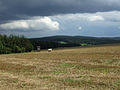 |
| Kapellenberg | 759 m | Elster Mountains | 1 km northwest of Schönberg | 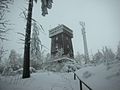 |
| Katzenhübel | 758 m | Central Ore Mountains | 1 km south of Heidelberg (Seiffen)/Erzgeb. | |
| Tellkoppe | 756 m | Eastern Ore Mountains | 1 km east of Kipsdorf | |
| Hochwald | 749 m | Zittau Mountains | 2 km south of Oybin |  |
| Goldene Höhe | 734 m | Vogtland | 4 km southeast of Auerbach/Vogtl. | |
| Laubberg | 733 m | Western Ore Mountains | 5 km southeast of Auerbach | |
| Steinberg | 732 m | Western Ore Mountains | 6 km south of Schneeberg | |
| Greifensteine | 731 m | Western Ore Mountains | 3 km west of Ehrenfriedersdorf | |
| Saydaer Höhe | 728 m | Eastern Ore Mountains | 2 km north of Sayda | |
| Spiegelwald | 728 m | Western Ore Mountains | in Grünhain-Beierfeld | |
| Fuchshöhe | 728 m | Western Ore Mountains | 7 km east of Annaberg-Buchholz | |
| Morgensternhöhe | 711 m | |||
| Dreibrüderhöhe | 689 m | Central Ore Mountains | 2 km west of Marienberg | |
| Plattenberg | 683 m | Elster Mountains | 4 km southeast of Bad Elster | |
| Eimberg | 676 m | Vogtland | 10 km east of Oelsnitz | |
| Steinberg b. Wernesgrün | 659 m | Vogtland | immediately next to Steinberg | |
| Jonsberg | 653 m | Zittau Mountains | east of Jonsdorf | |
| Buchberg | 652 m | Zittau Mountains | west of Jonsdorf | |
| Ziegenberg | 652 m | Western Ore Mountains | southeast of Zwönitz | |
| Schreckenberg | 649 m | Western Ore Mountains | 1 km west of Annaberg-Buchholz |  |
| Oelsener Höhe | 645 m | Eastern Ore Mountains | 4 km south of Bad Gottleuba | |
| Windberg | 627 m | Western Ore Mountains | northwest of Zwönitz | |
| Katzenstein (Affalter) | 627 m | Western Ore Mountains | 4 km northeast of Lößnitz | |
| Burgberg | 617 m | Eastern Ore Mountains | near Lichtenberg/Erzgeb. | |
| Kohlkuppe | 613 m | Eastern Ore Mountains | 2 km north of Schmiedeberg | |
| Hirschenstein | 610 m | Western Ore Mountains | 4 km west of Schneeberg | |
| Gemauerter Stein | 601 m | Western Ore Mountains | 1 km west of Aue | |
| Großer Stein | 619 m | Western Ore Mountains | 3 km west of Dorfchemnitz | |
| Gleesberg | 593 m | Western Ore Mountains | 1 km east of Schneeberg | |
| Fröhnberg | 587 m | Vogtland | 5 km west of Auerbach/Vogtl. | |
| Valtenberg | 586 m | Lusatian Highlands | 3 km southwest of Neukirch/Lausitz im Hohwald | |
| Kottmar | 583 m | Lusatian Highlands | 6 km east of Ebersbach/Sa. | |
| Töpfer | 580 m | Zittau Mountains | 1 km northeast of Oybin |  |
| Luchberg | 576 m | Eastern Ore Mountains | 4 km southwest of Reinhardtsgrimma |  |
| Ameisenberg | 575 m | Zittau Mountains | north of Oybin | |
| Schutzberg | 565 m | Vogtland | 3 km west of Weischlitz | |
| Eichert | 564 m | Western Ore Mountains | in Aue | |
| Großer Zschirnstein | 560 m | Elbe Sandstone Mountains | 3 km southwest of Schöna |  |
| Großer Winterberg | 556 m | Elbe Sandstone Mountains | 7 km east of Bad Schandau | |
| Czorneboh | 555 m | Lusatian Highlands | 3 km north of Cunewalde |  |
| Keilberg (Schneeberg) | 551 m | Western Ore Mountains | northwest of Schneeberg | |
| Hochstein | 542 m | Lusatian Highlands | 5 km south of Hochkirch | |
| Ungerberg | 537 m | Elbe Sandstone Mountains | 4 km northwest of Sebnitz |  |
| Geiersberg | 536 m | Ore Mountains | 2 km northeast of Burkhardtsdorf | |
| Lerchenberg (Plauen) | 525 m | Vogtland | 10 km northwest of Plauen | |
| Alter Berg | 524 m | Vogtland | 6 km southeast of Plauen | |
| Ottoberg | 520 m | Zittau Mountains | east of Waltersdorf | |
| Hirschknochen | 517 m | Western Ore Mountains | in Aue | |
| Eisenstein | 516 m | Western Ore Mountains | 2 km east of Aue | |
| Schellenberg | 516 m | Ore Mountains | in Augustusburg, 12 km east of Chemnitz | |
| Brünlasberg | 514 m | Western Ore Mountains | in Aue | |
| Oybin | 513 m | Zittau Mountains | immediately next to Oybin |  |
| Heidelsberg | 512 m | Western Ore Mountains | in Aue | |
| Kuhberg (Brockau) | 511 m | Vogtland | 2 km southwest of Netzschkau | |
| Oberoderwitzer Spitzberg | 510 m | Lusatian Highlands | south of Oderwitz |  |
| Breiteberg | 510.3 m | Zittau Mountains | 2 km south of Hainewalde |  |
| Adelsberg | 508 m | Ore Mountains | in Chemnitz-Adelsberg | |
| Augustusberg | 507 m | Eastern Ore Mountains | near Bad Gottleuba | |
| Kemmler | 507 m | Vogtland | 3 km southeast of Plauen |  |
| Weifaer Höhe | 504 m | Lusatian Highlands | 1 km northeast of Weifa | |
| Kleiner Winterberg | 499.9 m | Saxon Switzerland | 3 km northeast of Schmilka |  |
| Bieleboh | 499 m | Lusatian Highlands | 3 km south of Cunewalde | |
| Großer Picho | 498 m | Lusatian Highlands | 3 km west of Wilthen | |
| Sängerhöhe | 497 m | Zittau Mountains | west of Waltersdorf | |
| Wachberg | 496 m | Elbe Sandstone Mountains | 1 km north of Saupsdorf | |
| Udohöhe | 496 m | Ore Mountains | 1 km northwest of Oederan | |
| Götzhöhe | 493 m | Ore Mountains | north of Zschopau | |
| Großes Horn | 493 m | Elbe Sandstone Mountains | east of Bad Gottleuba | |
| Schlechteberg | 485 m | Lusatian Highlands | in Ebersbach | |
| Langenberger Höhe | 484 m | Saxon Uplands | 2 km north of Hohenstein-Ernstthal | |
| Totenstein | 483 m | Saxon Uplands | 1 km north of Chemnitz-Grüna | |
| Pfaffenberg | 479 m | Saxon Uplands | 1 km north of Hohenstein-Ernstthal | |
| Weifberg | 478 m | Elbe Sandstone Mountains | 2 km north of Hinterhermsdorf | |
| Wilisch | 476 m | Eastern Ore Mountains | 3 km south of Kreischa | |
| Frenzelsberg | 474 m | Lusatian Highlands | west of Seifhennersdorf | |
| Kleiner Zschirnstein | 473 m | Elbe Sandstone Mountains | 6 km east of Bad Schandau | |
| Großer Stein (Lusatian Highlands) | 471 m | Lusatian Highlands | south of Leutersdorf | |
| Richterberg | 470 m | Lusatian Highlands | east of Seifhennersdorf | |
| Sonnenhübel | 469 m | Lusatian Highlands | 1.5 km east of Oderwitz | |
| Lerchenberg | 466.6 m | Lusatian Highlands | between Neugersdorf and Eibau | |
| Raumberg | 459 m | Elbe Sandstone Mountains | 10 km southeast of Sebnitz | |
| Forstenberg | 458.8 m | Lusatian Highlands | south of Spitzkunnersdorf | |
| Rotstein | 455 m | Upper Lusatia | west of Sohland am Rotstein | 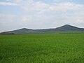 |
| Papststein | 451 m | Elbe Sandstone Mountains | 1 km southeast of Gohrisch |  |
| Schafberg | 449.5 m | Upper Lusatia | east of Löbau | |
| Löbauer Berg | 449 m | Upper Lusatia | 1 km east of Löbau | 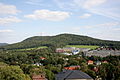 |
| Hochstein | 449 m | West Lusatian Hill Country and Uplands | 3 km southeast of Elstra | |
| Gohrisch | 448 m | Elbe Sandstone Mountains | 1 km south of Gohrisch | |
| Mönchswalder Berg | 447 m | Lusatian Highlands | 3 km north of Wilthen | |
| Hoher Hahn | 446 m | Lusatian Highlands | south of Tröbigau | 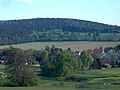 |
| Lampertsstein | 440 m | Elbe Sandstone Mountains | 5 km south of Königstein | |
| Großer Berg | 438 m | Lusatian Highlands | north of Großhennersdorf | |
| Schenkenberg | 434 m | am Südrand von Chemnitz | in the village of Reichenhain | |
| Pfaffenstein | 434 m | Elbe Sandstone Mountains | 2 km south of Königstein |  |
| Thromberg | 432 m | Lusatian Highlands | 6 km southeast of the town centre of Bautzen | |
| Schönbrunner Berg | 427.7 m | Lusatian Highlands | northeast of Großhennersdorf |  |
| Götzinger Höhe | 424 m | Lusatian Highlands | near Neustadt | |
| Scheibenberg | 422.7 m | Lusatian Highlands | west of Mittelherwigsdorf | |
| Beutenberg | 421 m | Saxon Uplands | Zeisigwald on the northeastern perimeter of Chemnitz | |
| Schwedenstein | 420 m | West Lusatian Hill Country and Uplands | 3 km east of Pulsnitz |  |
| Windmühlenberg | 420 m | Lusatian Highlands | north of Seifhennersdorf | |
| Weißer Stein | 420 m | Lusatian Highlands | southwest of Spitzkunnersdorf | |
| Landeskrone | 419 m | Upper Lusatia | 5 km southwest of Görlitz |  |
| Lilienstein | 416 m | Elbe Sandstone Mountains | 2 km north of Königstein | 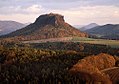 |
| Pfaffenberg | 416 m | Lusatian Highlands | north of Großschönau | |
| Kämpferberge | 415 m | Königshain Hills | 4 km west of Königshain | |
| Waitzdorfer Höhe | 413 m | Saxon Switzerland | 3 km south of Hohnstein | |
| Schwarzenberg | 413 m | West Lusatian Hill Country and Uplands | 1 km west of Elstra | |
| Keulenberg | 413 m | West Lusatian Hill Country and Uplands | 2 km southeast of Königsbrück | |
| Hofeberg | 413 m | Lusatian Highlands | 2 km east of Leutersdorf | |
| Finkenhübel | 410.6 m | Lusatian Highlands | west of Großschönau | |
| Schanzberg | 408.6 m | Lusatian Highlands | northeast of Oberseifersdorf | |
| Beckenberg | 407.6 m | Lusatian Highlands | north of Eibau | 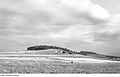 |
| Hochstein | 406 m | Eastern Upper Lusatia | 4 km northwest of Königshain | |
| Pferdeberg | 406 m | Lusatian Highlands | east of Oderwitz | |
| Hutberg | 405 m | Lusatian Highlands | east of Oderwitz |  |
| Wäschberg | 401.7 m | Ore Mountains | 500 m northwest of Bräunsdorf | |
| Tröbigauer Berg | 401 m | Lusatian Highlands | north of Tröbigau |  |
| Lasensteine | 399 m | Saxon Switzerland | 2 km south of Krippen | |
| Fuchsberg | 398 m | Saxon Uplands | Zeisigwald on the northeastern edge of Chemnitz | |
| Schwarzer Berg | 394 m | Upper Lusatia | 1 km west of Jauernick-Buschbach | |
| Klosterberg | 394 m | Lusatian Highlands | south of Demitz-Thumitz |  |
| Spitzer Berg | 393 m | Lusatian Highlands | south of Großhennersdorf | |
| Cottaer Spitzberg | 391 m | Elbe Sandstone Mountains | 1 km east of Cotta |  |
| Kleinhennersdorfer Stein | 389 m | Elbe Sandstone Mountains | 3 km west of Bad Schandau | |
| Tröbigauer Butterberg | 388 m | Lusatian Highlands | between Tröbigau and Naundorf | |
| Kühnelsberg | 386 m | Lusatian Highlands | north of Oderwitz | |
| Zirkelstein | 384.5 m | Saxon Switzerland | 5 km southeast of Bad Schandau | 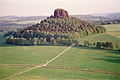 |
| Triebenberg | 383 m | Schönfeld Upland | highest point of Dresden | |
| Steinberg | 378 m | Ore Mountains | 0,5 km east of Riechberg | |
| Höhe | 376.6 m | Lusatian Highlands | east of Eibau | |
| Bubenik | 376 m | Lusatian Highlands | 4 km west of Löbau | |
| Funkenburg | 376 m | Lusatian Highlands | 1 km northeast of Wehrsdorf | |
| Langer Berg | 375 m | Lusatian Highlands | west of Großhennersdorf | |
| Jungfernstein | 373.2 m | Lusatian Highlands | northeast of Tröbigau |  |
| Gleichenstein | 373 m | Ore Mountains | 1 km east of Bräunsdorf | |
| Kohlbornstein | 371 m | Elbe Sandstone Mountains | 1 km south of Krippen | |
| Wilhelmshöhe | 368 m | Lusatian Highlands | west of Oderwitz | 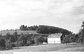 |
| Borsberg | 361 m | Schönfeld Upland | in the east of Dresden |  |
| Königstein | 360.6 m | Elbe Sandstone Mountains | 1 km west of Königstein |  |
| Steinberg | 357 m | Lusatian Highlands | north of Wittgendorf | |
| Windberg (Freital) | 352 m | Saxon Uplands | in Freital |  |
| Kaiserkrone | 351 m | Elbe Sandstone Mountains | near Schöna |  |
| Quirl | 350 m | Elbe Sandstone Mountains | 2 km south of Königstein | |
| Rochlitzer Berg | 348 m | near Rochlitz | old volcano |  |
| Gohlig (Goldene Höhe) | 346 m | Saxon Uplands | 1 km south of Bannewitz |  |
| Wolfsberg | 343 m | Elbe Sandstone Mountains | 1 km south of Reinhardtsdorf-Schöna |  |
| Kleiner Bärenstein | 338 m | Elbe Sandstone Mountains | 1 km north of Thürmsdorf | |
| Eisberg | 330 m | Lusatian Highlands | west of Großhennersdorf | |
| Großer Bärenstein | 330 m | Elbe Sandstone Mountains | 2 km southeast of Stadt Wehlen | |
| Schöne Höhe | 328 m | Elbe Sandstone Mountains | 1 km southwest of Dürrröhrsdorf-Dittersbach | |
| Sandberg | 323.8 m | Lusatian Highlands | north of Schlegel | |
| Baeyerhöhe | 320.5 m | Meißen Upland | municipality of Klipphausen | |
| Collmberg | 312 m | Leipzig Bay | 6 km west of Oschatz |  |
| Schülerberg | 306 m | Lusatian Highlands | north of Mittelherwigsdorf | |
| Bastei | 305 m | Elbe Sandstone Mountains | 1 km west of Rathen |  |
| Rauenstein | 304 m | Elbe Sandstone Mountains | 2 km southeast of Stadt Wehlen | |
| Hutberg | 297 m | West Lusatian Hill Country and Uplands | 2 km west of Kamenz | |
| Monumentberg | 293 m | Upper Lusatia | 1 km east of Groß Radisch | 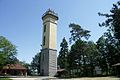 |
| Strohmberg | 264 m | Lusatian Highlands (Vorland) | 2,5 km south of Weißenberg | |
| Wahnsdorfer Kuppe | 246.4 m | Lößnitz | 5 km south Moritzburg | |
| Löbenberg | 240 m | Leipzig Bay | 2 km northwest of Hohburg | |
| Reichenberg | 223 m | Lößnitz | municipality of Moritzburg | |
| Oßlinger Berg | 204 m | Upper Lusatia | 1 km west of Oßling | |
| Heidehöhe Heideberg near Gröden | 201 m | Großenhainer Pflege | 2 km north of Strauch | |