
The Ore Mountains lie along the Czech–German border, separating the historical regions of Bohemia in the Czech Republic and Saxony in Germany. The highest peaks are the Klínovec in the Czech Republic, which rises to 1,244 metres (4,081 ft) above sea level and the Fichtelberg in Germany.

Eibenstock is a town in the western Ore Mountains, in the Erzgebirgskreis, Saxony, Germany. It is situated near the river Mulde.

Schwarzenberg is a town in the district of Erzgebirgskreis in Saxony’s Ore Mountains, near the German–Czech border. The town lies roughly 15 km southeast of Aue, and 35 km southwest of Chemnitz.

Johanngeorgenstadt is a mining town in Saxony’s Ore Mountains, 17 km south of Aue, and 27 km northwest of Karlovy Vary. It lies in the district of Erzgebirgskreis, on the border with the Czech Republic, is a state-recognized health resort (Erholungsort), and calls itself Stadt des Schwibbogens. Its population decline since the 1950s has been extremely severe falling from 45,000 residents in 1953 to only about one tenth of that now.
Oberwiesenthal is a town and a ski resort in the district of Erzgebirgskreis in Saxony in Germany. It is situated in the Ore Mountains, on the border with the Czech Republic, 19 km south of Annaberg-Buchholz, and 23 km northeast of Karlovy Vary. At 914 metres (2,999 ft), it is the highest town in Germany. The Olympic and World Championships goldmedalist in ski jumping Jens Weißflog competed for SC Tractor Oberwiesenthal and Oberwiesenthaler SV.
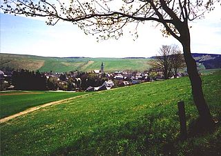
Schönheide is a community in Saxony's district of Erzgebirgskreis. It lies in the western Ore Mountains, and was founded as an industrial village.

Sosa is a former municipality in the western Ore Mountains, in the Erzgebirgskreis, Saxony, Germany. It is a state-recognized health resort, that has belonged to the town Eibenstock since 1 January 2011.

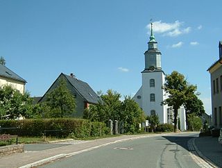
Stützengrün is a community in the district of Erzgebirgskreis, Saxony, Germany.

Zschorlau is a community in the district of Erzgebirgskreis in Saxony, Germany.

Auersberg is a mountain in the Ore Mountains in Saxony, southeastern Germany. Auersberg is a 1018.2 m above sea level. It is located in the district of Wildenthal not far from the Czech border southeast of Eibenstock and northwest of Johanngeorgenstadt.

The Ore Mountain passes are crossings and passages over the crest of the Ore Mountains in Central Europe, over which tracks, roads, railway lines and pipelines run from the Free State of Saxony in the Federal Republic of Germany to Bohemia in the Czech Republic and vice versa.

The Western Ore Mountains is a natural region that forms the westernmost part of the Ore Mountains in the German state of Saxony. It is also part of the major landscape unit known as the Saxon Highlands and Uplands. It extends eastwards to include the valley of the Schwarzwasser, and, below its mouth, that of the Zwickauer Mulde, and incorporates the western parts of the former major units known as the Lower and Upper Western Ore Mountains, no. 423, as well as the Southern Slopes of the Ore Mountains, no. 420.

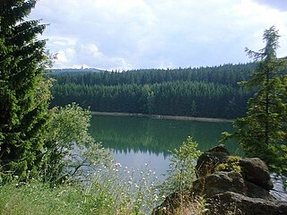
Eibenstock Dam near Eibenstock in the Ore Mountains, Germany, is the largest dam in the Free State of Saxony in terms of the height of the dam above the valley floor, and its reservoir is the largest in volume in Saxony. The dam impounds the waters of the Zwickauer Mulde and supplies drinking water to the region of Chemnitz and Zwickau, as well as providing flood protection, delivering extra water during times of drought and, to a lesser extent, generating electricity from hydropower. Its dimensions make it the second largest drinking water reservoir in Germany's new federal states.
The Sosa Dam is a dam in the Free State of Saxony in East Germany. It supplies drinking water to the Western Ore Mountains as well as acting as flood protection.
Lauta is a village in the Saxon town of Marienberg in the German district of Erzgebirgskreis.
Jugel is a division of the town of Johanngeorgenstadt in the German district of Erzgebirgskreis. This dispersed settlement is surrounded by woods, is divided into Ober- and Unterjugel and runs along the German-Czech border from the Lehmergrund to the crest of the Western Ore Mountains. In the vicinity lies the 980 metre-high Scheffelsberg. Jugel is a tourist destination for hikers and winter sportsmen.

Satzung is a village in the Saxon municipality of Marienberg, which is in the district of Erzgebirgskreis in the German Ore Mountains.
Gehringswalde, a so-called Waldhufendorf, is situated about 1.5 km east of Wolkenstein in the Ore Mountains. It extends for about 1.5 km along the valley of a stream which joins the Zschopau river ca. 1.5 km west of Warmbad. The nearby Hüttengrundmühle is also part of the village. The mountain Dreibrüderhöhe lies ca. 3 km east of Gehringswalde.

Muldenhammer is a former subdivision of the town of Eibenstock in the Ore Mountains. It originated from an iron hammer forge, first mentioned in the 16th century and was abandoned in 1974 due to the construction of Eibenstock Dam.
Hundshübel is a village in Erzgebirgskreis district of Saxony, forming a subdivision of the municipality of Stützengrün in the Ore Mountains. It is located north of Eibenstock Dam on federal highway B 169.


