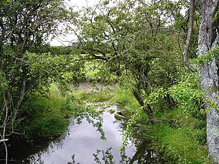
The source or headwaters of a river or stream is the furthest place in that river or stream from its estuary or confluence with another river, as measured along the course of the river.

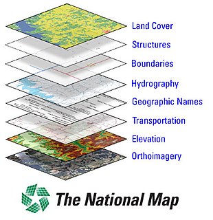
The National Map is a collaborative effort of the United States Geological Survey (USGS) and other federal, state, and local agencies to improve and deliver topographic information for the United States. The purpose of the effort is to provide "...a seamless, continuously maintained set of public domain geographic base information that will serve as a foundation for integrating, sharing, and using other data easily and consistently".

The Usarp Mountains is a major Antarctic mountain range, lying westward of the Rennick Glacier and trending N-S for about 190 kilometres (118 mi). The feature is bounded to the north by Pryor Glacier and the Wilson Hills. Its important constituent parts include Welcome Mountain, Mount Van der Hoeven, Mount Weihaupt, Mount Stuart, Mount Lorius, Smith Bench, Mount Roberts, Pomerantz Tableland, Daniels Range, Emlen Peaks, Helliwell Hills and Morozumi Range.

Bridgeton is a compact neighborhood of detached houses, rowhouses, apartment and condominium complexes, and houseboats in the north and northeast sections of Portland, Oregon. It occupies a narrow strip of land around a levee between the Columbia River and Bridgeton Slough.

Isbrecht Glacier is a small glacier flowing south from Thurston Island in Antarctica between Cox Glacier and Hale Glacier. It was named by the Advisory Committee on Antarctic Names after JoAnn Isbrecht of the United States Geological Survey (USGS), Flagstaff, Arizona, a satellite image processing specialist who was part of the USGS team that compiled the 1:5,000,000-scale Advanced Very High Resolution Radiometer maps of Antarctica and the 1:250,000-scale Landsat image maps of the Siple Coast area in the 1990s.

The United States Geological Survey is a scientific agency of the United States government. The scientists of the USGS study the landscape of the United States, its natural resources, and the natural hazards that threaten it. The organization has four major science disciplines, concerning biology, geography, geology, and hydrology. The USGS is a fact-finding research organization with no regulatory responsibility.

Amos Glacier is a 3-nautical-mile (6 km) long glacier that flows southeast from Bettle Peak to a juncture with the Blue Glacier, in Victoria Land, Antarctica. It was named in 1992 by the Advisory Committee on Antarctic Names after Larry Leon Amos, a civil engineer with the United States Geological Survey (USGS), and a member of the USGS two man astronomic surveying team to South Pole Station and Byrd Station in the 1969–70 field season. Among other work, the team established the position of the Geographic South Pole and established a tie to the Byrd Ice Strain net which had been under study for several years.

Barnett Glacier is a large glacier in the Anare Mountains that flows east along the south side of Tapsell Foreland into Smith Inlet, northern Victoria Land, Antarctica. It was mapped by the United States Geological Survey (USGS) from surveys and from U.S. Navy air photos, 1960–63, and named by the Advisory Committee on Antarctic Names after Donald C. Barnett, USGS topographic engineer, a member of USGS Topo East and West, 1962–63, in which the expedition extended geodetic control from the area of Cape Hallett to the Wilson Hills and from the foot of Beardmore Glacier through the Horlick Mountains. The glacier lies on the Pennell Coast, a portion of Antarctica lying between Cape Williams and Cape Adare.

Chavez Glacier is a glacier about 10 nmi long flowing south from Canisteo Peninsula into Cranton Bay. It was named by the Advisory Committee on Antarctic Names after Pat Chavez of the United States Geological Survey (USGS), Flagstaff, Arizona, co-leader of the USGS team that compiled the 1:5,000,000-scale Advanced Very High Resolution Radiometer maps of Antarctica in the 1990s.

Cooke Glacier is a glacier about 6 nautical miles (11 km) long flowing north from the northern end of the Fletcher Peninsula. It was named by the Advisory Committee on Antarctic Names after Kirsten Cooke Healey, of the United States Geological Survey (USGS), Woods Hole, Massachusetts, a computer graphics specialist from the mid-1990s onwards for the USGS project that is compiling the Satellite Image Atlas of Glaciers and 25 Glaciological and Coastal-Change Maps of Antarctica.
Hill Glacier is a broad glacier that drains the west-central part of Spaatz Island, Antarctica, at the south side of Ronne Entrance. It was mapped by the United States Geological Survey (USGS) from surveys and U.S. Navy aerial photographs, 1961–66, and was named by the Advisory Committee on Antarctic Names for Lennie J. Hill, a USGS topographic engineer who was a member of the Marie Byrd Land Survey Party, 1967–68.

Aaron Glacier is a 4-mile (6.4 km) long Antarctic glacier which drains between the Janulis Spur and the Gray Spur in the Thiel Mountains. The name was proposed by Peter Bermel and Arthur B. Ford, co-leaders of the U.S. Geological Survey (USGS) Thiel Mountains party from 1960 to 1961. It was named for Johm M. Aaron, a USGS geologist and member of the 1960–61 and 1961–62 field parties to the Thiel Mountains.

Neepaulakating Creek is a 2.4-mile long (3.8 km) tributary of Papakating Creek in Wantage Township in Sussex County, New Jersey in the United States. It is one of three streams feeding the Papakating Creek, a major contributor to the Wallkill River. Although the stream was dammed in the 1950s to create Lake Neepaulin as the focal point of a private residential development, the stream did not receive a name until 2002. Residents chose a name that combined elements of the names "Neepaulin" and "Papakating", and submitted a proposal to the United States Board of Geographic Names. The name was approved in 2004.
Pine Mountain is a summit in St. Francois County in the U.S. state of Missouri. The summit has an elevation of 1,499 feet (457 m). The mountain is about 3.5 miles south of Bismarck along Missouri Route N. The peak rises just south of the confluence of Indian Creek with the St. Francis River.

Murphy Hill is a mountain located in Central New York Region of New York east of Cooperstown, New York.

Gifford Hill is a small mountain chain in the Central New York Region of New York. It is located northeast of Oneonta, New York. It is made of three main peaks the highest being 1928 feet. Gifford Hill is named for the Gifford Family who moved to the area in 1803 and settled along the Oneonta Creek on what is now called Gifford Hill.


