List of populated places in Karaman Province

Last updated
Karaman Province Karaman districts.png
Karaman Province

Below is the list of populated places in Karaman Province, Turkey by the districts. In the following lists first place in each list is the administrative center of the district. [1]

Karaman Province Province of Turkey in West Anatolia

Karaman Province is a province of south-central Turkey. It has an area of 9,163 km2. It has a population of 232,633. According to the 2000 census the population was 243,210. Population density is 27.54 people/km2. The traffic code is 70. The capital is the city of Karaman. Karaman was the location of the Karamanid emirate, which came to an end in 1486.

Turkey Republic in Western Asia

Turkey, officially the Republic of Turkey, is a transcontinental country located mainly in Western Asia, with a smaller portion on the Balkan Peninsula in Southeast Europe. East Thrace, located in Europe, is separated from Anatolia by the Sea of Marmara, the Bosphorous strait and the Dardanelles. Turkey is bordered by Greece and Bulgaria to its northwest; Georgia to its northeast; Armenia, the Azerbaijani exclave of Nakhchivan and Iran to the east; and Iraq and Syria to the south. Istanbul is the largest city, but more central Ankara is the capital. Approximately 70 to 80 per cent of the country's citizens identify as Turkish. Kurds are the largest minority; the size of the Kurdish population is a subject of dispute with estimates placing the figure at anywhere from 12 to 25 per cent of the population.

Contents

Karaman

Ada, Karaman Village in Karaman Province, Turkey

Ada is a village in the central district (Karaman) of Karaman Province, Turkey. At 36°54′N32°54′E it is situated in the mountainous area to the south east of Karaman. It is called Ada because it is almost surrounded by creeks. Its distance to Karaman is 65 kilometres (40 mi). The population of the village was 435 as of 2011.

Ağaçyurdu, Karaman Village in Karaman Province, Turkey

Ağaçyurdu is a village the central district (Karaman) of Karaman Province, Turkey. At 37°27′N33°30′E it is situated to the east of Turkish state highway . Its distance to Karaman is 28 kilometres (17 mi). The population is of Ağaçyurdu is 128. as of 2011. Major economic activity of the village is agriculture. Main crops are citrus and apple. Dairying is a secondary activity.

Ağılönü, Karaman Village in Karaman Province, Turkey

Ağılönü is a village the central district (Karaman) of Karaman Province, Turkey. At 37°14′N33°22′E it is situated to the east of Karaman and to the South of Turkish state highway which connects Karaman to east. Its distance to Karaman is 17 kilometres (11 mi). The population is of Ağılönü is 307. as of 2011. Major economic activities of the village are agriculture and animal breeding..


Ayrancı

Ayrancı District in Turkey

Ayrancı is a town and district of Karaman Province in the Central Anatolia region of Turkey. According to 2000 census, population of the district is 13,212 of which 3,153 live in the town of Ayrancı.


Başyayla

Başyayla District in Turkey

Başyayla is a town and district of Karaman Province in the Central Anatolia region of Turkey. According to 2000 census, population of the district is 8,155 of which 5,514 live in the town of Başyayla.


Ermenek

Ermenek District in Turkey

Ermenek is a town and district of Karaman Province in the Mediterranean region of Turkey. As ancient Germanicopolis, a former bishopric, it remains a Latin Catholic titular see.

İkizçınar, Ermenek

İkizçın is a village in the district of Ermenek, Karaman Province in Turkey.


Kazımkarabekir

Kazımkarabekir District in Turkey

Kazımkarabekir is a town and district of Karaman Province in the Central Anatolia region of Turkey. According to 2000 census, population of the district is 5,442 of which 3,634 live in the town of Kazımkarabekir.


Sarıveliler


Related Research Articles

Sarıveliler District in Turkey

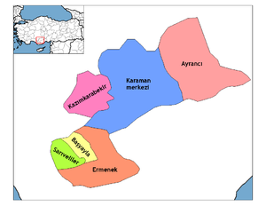
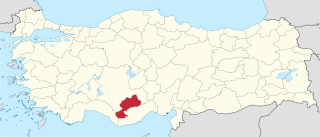
Sarıveliler is a town and district of Karaman Province in the Central Anatolia region of Turkey. According to 2000 census, population of the district is 21,308 of which 6,718 live in the town of Sarıveliler.

Ermenek Dam

The Ermenek Dam is a double-curvature concrete arch dam located on the Göksu River in Karaman Province, Turkey. The 210 m (689 ft) tall dam was the highest in Turkey at the time of its construction and currently ranks third after Deriner Dam and Yusufeli Dam. The development was backed by the Turkish State Hydraulic Works. Completed in 2009, the primary purpose of the dam is to support its 300 MW power station.

Ayrancı is a town and district of Karaman Province in the Central Anatolia region of Turkey.

Kazancı is a Turkish place name and may refer to:

Ardıçkaya Village in Karaman Province, Turkey

Ardıçkaya is a village in Ermenek district of Karaman Province, Turkey. It is situated in a high plateau of Taurus Mountains at 36°33′N32°45′E. Distance to Ermenek is 56 kilometres (35 mi) and to Karaman is 200 kilometres (120 mi). The population of the town is around 1700 as of 2010. The name of the town refers to junipers around the village. The old name of the village is Nadire.

Nûre Sûfi Bey was the predecessor of Karamanid dynasty, a Turkish dynasty which ruled part of Anatolia in the 14th and 15th centuries as a rival of the Ottoman Empire. He was the son of Hodja Sad al-Din who had come from Arran, staying for some years near Sivas.

Kerîmeddin Karaman Beg (Turkish) was a Turkmen chief founder of the dynasty Karaman-oğhlu or Karamanoğulları. The province and city of Larandia was renamed Karaman in his honor.

Mahmut of Karaman was a bey of Karaman Beylik, a Turkish principality in Anatolia in the 14th century.

Balkusan Village in Karaman Province, Turkey

Balkusan is a village in Ermenek district of Karaman Province, Turkey. It is situated in a high plateau of the Taurus Mountains at 36°46′N32°53′E. Distance to Ermenek is 22 kilometres (14 mi). The population of the town is 211 as of 2014. The origin of the village residents are Turkmens of Afshar tribe who had migrated from the Central Asia in the Medieval Age. The name of the village may refer to Balasagun, a historical city in Kyrgyzstan. The village was a more important place in the Medieval Age. The tombs of Karaman Bey and Mahmut Bey, beys of Karamanoğlu beylik are in the village. Main economic activity of the village is agriculture. Beehiving is another important activity.

Süleyman of Karaman was a bey of the Karaman Beylik, a Turkish principality in Anatolia in the 14th century.

Taşeli is a karst plateau in southern Turkey, in the ancient Cilicia Trachea. Taşeli plateau roughly covers the districts of Ermenek, Başyayla, Sarıveliler, Mut, Gülnar, and Taşkent as well as interior uplands of the coastal Anamur and Bozyazı districts in Mersin Province and Gazipaşa in Antalya Province. The river Göksu and its main tributary Ermenek Çayı flow on the plateau.

Kayaönü is a Turkishplace name and it may refer to;

Ayrancı station is a station in the Karaman Province of Turkey. Located just north of Ayrancı, 2.3 km (1.4 mi) north of the town center. TCDD Taşımacılık operates a daily intercity train from Konya to Adana, which stops at the station.

Elmayurdu Village in Karaman Province, Turkey

Elmayurdu is a village in Karaman Province, Turkey

Çamlıca, Ermenek Village in Karaman Province, Turkey

Çamlıca is a village in Karaman Province, Turkey

References