
Below is the list of populated places in Artvin Province, Turkey by the districts. In the following lists, first place in each list is the administrative center of the district. [1]
Below is the list of populated places in Artvin Province, Turkey by the districts. In the following lists, first place in each list is the administrative center of the district. [1]

Artvin Province is a province in Turkey, on the Black Sea coast in the northeastern corner of the country, on the border with Georgia.
Erenköy may refer to:

Arhavi, is a town and district of Artvin Province located in the Black Sea region of Turkey. The terrain is hilly and mountainous. Area of the city center is about 6 km2 (2.3 sq mi), and the total district area is 314 km2 (121 sq mi). The length of the coast is about 10 km (6.2 mi). In 2011 with 19.362 district population the 5th biggest district population of Artvin province. With 15.622 city population, in Turkey 308th and in Artvin province after Artvin and Hopa the 3rd biggest population. Laz people generate a large portion of the population.
Şavşat is a town and district of Artvin Province in the Black Sea region, between the cities of Artvin and Kars on the border with Georgia at the far eastern end of Turkey.

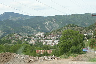
Ardanuç is a town and district in Artvin Province in Turkey's Black Sea region of Turkey, 32 km east of Artvin. The name Ardanuç derives from Lazuri language and Armenian.

There is considerable dialectal variation in Turkish.
Dereiçi may refer to the following places in Turkey:

The Cankurtaran Tunnel, a.k.a.Hopa Cankurtaran Tunnel, is a road tunnel located in Artvin Province. It forms part of the Hopa-Borçka Highway D.010 in northeastern Turkey.