
Below is the list of populated places in Osmaniye Province, Turkey by the districts. In the following lists first place in each list is the administrative center of the district. [1]
Below is the list of populated places in Osmaniye Province, Turkey by the districts. In the following lists first place in each list is the administrative center of the district. [1]

Kadirli, historically Kars or Karsbazar, is a city in Osmaniye Province in the Mediterranean region of Turkey. It is the seat of Kadirli District. Its population is 98,469 (2022). It is located in the Çukurova plain, 41 kilometres from the province's capital, Osmaniye. It is located near the ancient site of Flaviopolis.

Osmaniye Province is a province in south-central Turkey. It was named Cebel-i Bereket in the early republic until 1933, when it was incorporated into Adana Province. It was made a province again in 1996. Its area is 3,320 km2, and its population is 559,405 (2022). The province is situated in Çukurova, a geographical, economical and cultural region. The capital of the province is Osmaniye. Other major towns include Kadirli and Düziçi.
Toprakkale is a town in Osmaniye Province in the Mediterranean region of Turkey. It is the seat of Toprakkale District. Its population is 11,411 (2022). It is located at 10 km to the west of Osmaniye. Its name comes from an Abbasid castle near the city.
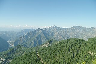
The Amanian Gate or Bahçe Pass, also known as the Amanus Pass or Amanides Pylae, is a mountain pass located on the border between Osmaniye and Gaziantep provinces in south-central Turkey. The pass provides a way through the northern Amanus Mountains, connecting Cilicia to southern Anatolia and northern Syria. It is one of two passes through the Amanus, the other being the Syrian Gate to the south.
Yarbaşı is a town (belde) in the Düziçi District, Osmaniye Province, Turkey. Its population is 3,559 (2022). It is on the Osmaniye-Düziçi highway, 5 kilometres (3.1 mi) from central Düziçi and 24 kilometres (15 mi) from the city of Osmaniye.
Ellek is a town (belde) in the Düziçi District, Osmaniye Province, Turkey. Its population is 6,277 (2022). The distance to Düziçi is 15 kilometres (9.3 mi) and to Osmaniye is 30 kilometres (19 mi). Ellek, a former village, was declared a seat of township after being merged with another village in 1968. Main economic activity is peanut agriculture and dairying.
Irenopolis or Eirenopolis or Eirenoupolis was an ancient Roman, Byzantine and medieval city in northeastern Cilicia, not far from the Calycadnus river, also known briefly as Neronias in honour of the Roman emperor Nero. Irenopolis was also an episcopal see that is now included in the Catholic Church's list of titular sees.
Bahçe Wind Farm or Gökçedağ Wind Farm is an onshore wind power plant in the Bahçe district of Osmaniye Province, in the eastern Mediterranean Region of Turkey. Consisting of 54 wind turbines with an installed output power of 135 MW in total, the wind farm was the country's largest one when it was commissioned in 2009.

The 81 provinces of Turkey are divided into 973 districts. In the Ottoman Empire and in the early Turkish Republic, the corresponding unit was the kaza.
Bahçe is a Turkish place name that may refer to the following places in Turkey:

The Battle of Kanlı Geçit took place between Turkish National Forces and the French Third Republic during the Franco-Turkish War. The battle began on November 1, 1920, and ended with a Turkish victory on November 9. The exact number of casualties are unknown.

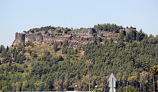
Karatepe-Aslantaş Open-Air Museum is an open-air museum in Osmaniye Province, Turkey. Karatepe is the location while Aslantaş refers to the lion figure on stone sculptures. The site is situated inside a national park with the same name.

Karatepe-Aslantaş National Park, established in 1958, is a national park in southern Turkey. Situated on the banks of a dam reservoir, it contains an archaeological open-air museum.

Bahçe station is a railway station in Turkey. It is located at 37°12′04″N36°34′42″E in Bahçe ilçe (district) of Osmaniye Province.
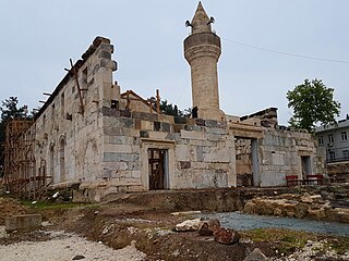
Ala Mosque is a historical mosque in Kadirli, Osmaniye Province, Turkey.

Kadirli District is a district of the Osmaniye Province of Turkey. Its seat is the city of Kadirli. Its area is 1,021 km2, and its population is 127,004 (2022).
Osmaniye District is a district of the Osmaniye Province of Turkey. Its seat is the city of Osmaniye. Its area is 859 km2, and its population is 285,430 (2022).
Akçataş is a village in the Sumbas District of Osmaniye Province, Turkey. The village is located 70 km from the provincial capital of Osmaniye and 15 km from the district center of Sumbas.