Related Research Articles

The Zambezi is the fourth-longest river in Africa, the longest east-flowing river in Africa and the largest flowing into the Indian Ocean from Africa. Its drainage basin covers 1,390,000 km2 (540,000 sq mi), slightly less than half of the Nile's. The 2,574 km (1,599 mi) river rises in Zambia and flows through eastern Angola, along the north-eastern border of Namibia and the northern border of Botswana, then along the border between Zambia and Zimbabwe to Mozambique, where it crosses the country to empty into the Indian Ocean.

A transboundary protected area (TBPA) is an ecological protected area that spans boundaries of more than one country or sub-national entity. Such areas are also known as transfrontier conservation areas (TFCAs) or peace parks.
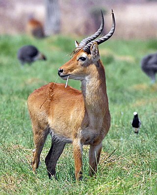
The puku is a medium-sized antelope found in wet grasslands in southern Democratic Republic of Congo, Namibia, Tanzania, Zambia and more concentrated in the Okavango Delta in Botswana. Nearly one-third of all puku are found in protected areas, zoos, and national parks due to their diminishing habitat.

The Luangwa River is one of the major tributaries of the Zambezi River, and one of the four biggest rivers of Zambia. The river generally floods in the rainy season and then falls considerably in the dry season. It is one of the biggest unaltered rivers in Southern Africa and the 52,000 square kilometres (20,000 sq mi) that make up the surrounding valley are home to abundant wildlife.

Kafue National Park is the largest national park in Zambia, covering an area of about 22,400 km2. It is the second largest national park in Africa and is home to 152 different species of mammals. There are also 515 bird species, 70 reptile species, 58 species of fish and 36 amphibious species.
North Luangwa National Park is a national park in Zambia, the northernmost of the three in the valley of the Luangwa River. Founded as a game reserve in 1938, it became a national park in 1972 and now covers 4,636 km².

South Luangwa National Park is in eastern Zambia, the southernmost of three national parks in the valley of the Luangwa River. It is a world-renowned wildlife haven which is known to locals simply as "the South Park." Concentrations of game along the meandering Luangwa River and its lagoons are amongst the most intense in Africa. The river teems with hippo and crocodile and provides a lifeline for one of the greatest diversities of habitat and wildlife, supporting more than 60 species of mammals and over 400 species of birds. It marks the end of the Great Rift Valley.

Mosi-oa-Tunya National Park is a UNESCO World Heritage Site that is home to one-half of the Mosi-oa-Tunya—"The Smoke that Thunders", known worldwide as Victoria Falls—on the Zambezi River. The river forms the border between Zambia and Zimbabwe, so the falls are shared by the two countries, and the park is twin to the Victoria Falls National Park on the Zimbabwean side.

Kasanka National Park is a park located in the Chitambo District of Zambia’s Central Province. At roughly 390 km2 (150 sq mi), Kasanka is one of Zambia’s smallest national parks. Kasanka was the first of Zambia’s national parks to be managed by a private-public partnership. The privately funded Kasanka Trust Ltd has been in operation since 1986 and undertakes all management responsibilities, in partnership with the Department of National Parks and Wildlife. The park has an average elevation between 1,160 m (3,810 ft) and 1,290 m (4,230 ft) above mean sea level. It has a number permanent shallow lakes and water bodies with the largest being Wasa. There are five perennial rivers in the park, with the largest being the Luwombwa River. The Luwombwa is the only river that drains the NP, which flows out in the northwestern corner. It is a tributary of the Luapula, which further upstream also drains the Bangweulu Swamp and forms the main source of the Congo River. Although Kasanka NP is part of the Greater Bangweulu Ecosystem, there is no direct hydrological connection between the park and the Bangweulu Wetlands.

There are four categories of protected areas in India, constituted under the Wildlife Protection Act, 1972. Tiger reserves consist of areas under national parks and wildlife sanctuaries. There are 53 tiger reserves in India. As of January 2023, the protected areas of India cover 173,629.52 square kilometres (67,038.73 sq mi), roughly 5.28% of the total geographical area of the country.

Central Province is one of Zambia's ten provinces. The provincial capital is Kabwe, which is the home of the Mulungushi Rock of Authority. Central Province has an area of 94,394 km (58,654 mi). It borders eight other provinces and has eleven districts. The total area of forest in the province is 9,095,566 ha, and it has a national park and three game management areas. The first mine in the region was opened up in 1905 making the then Broken Hill town the first mining town. In 1966, the town's name was reverted to its indigenous name - Kabwe meaning 'ore' or 'smelting'.
The Kafue Flats are a vast area of swamp, open lagoon and seasonally inundated flood-plain on the Kafue River in the Southern, Central and Lusaka provinces of Zambia. They are a shallow flood plain 240 km (150 mi) long and about 50 km (31 mi) wide, flooded to a depth of less than a meter in the rainy season, and drying out to a clayey black soil in the dry season.

The wildlife of Zambia refers to the natural flora and fauna of Zambia. This article provides an overview, and outline of the main wildlife areas or regions, and compact lists of animals focusing on prevalence and distribution in the country rather than on taxonomy. More specialized articles on particular groups are linked from here.
The biomes and ecoregions in the ecology of Zambia are described, listed and mapped here, following the World Wildlife Fund's classification scheme for terrestrial ecoregions, and the WWF freshwater ecoregion classification for rivers, lakes and wetlands. Zambia is in the Zambezian region of the Afrotropical biogeographic realm. Three terrestrial biomes are well represented in the country . The distribution of the biomes and ecoregions is governed mainly by the physical environment, especially climate.

The following outline is provided as an overview of and topical guide to Zambia:
Zambia, officially known as the Republic of Zambia, is a landlocked country in Southern Africa. The neighbouring countries are the Democratic Republic of the Congo to the north, Tanzania to the north-east, Malawi to the east, Mozambique, Zimbabwe, Botswana, and Namibia to the south, and Angola to the west. The capital city is Lusaka, located in the southeast of the country. The population is concentrated mainly around the capital and the Copperbelt to the northwest.
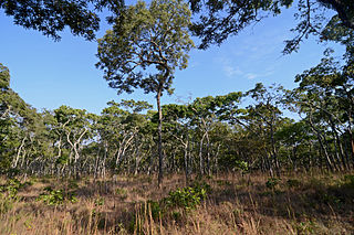
The Central Zambezian miombo woodlands ecoregion spans southern central Africa. Miombo woodland is the predominant plant community. It is one of the largest ecoregions on the continent, and home to a great variety of wildlife, including many large mammals.
Kavango–Zambezi Transfrontier Conservation Area is the second-largest nature and landscape conservation area in the world, spanning the international borders of five countries in Southern Africa. It includes a major part of the Upper Zambezi River and Okavango basins and Delta, the Caprivi Strip of Namibia, the southeastern part of Angola, southwestern Zambia, the northern wildlands of Botswana and western Zimbabwe. The centre of this area is at the confluence of the Zambezi and Chobe Rivers where the borders of Botswana, Namibia, Zambia and Zimbabwe meet. It incorporates a number of notable national parks and nature sites, including Chobe National Park, Hwange National Park, and the Victoria Falls. The region is home to a population of approximately 250,000 animals, including the largest population of African Elephants in the world.
Bia National Park is a national park in the Bia district in the Western Region of Ghana. It is also a biosphere reserve with a 563 square kilometer resource reserve. It has some of Ghana's last remnants of relatively untouched forest complete with its full diversity of wildlife. Some of the tallest trees left in West Africa are found in this national park. It constitutes a twin conservation area called the Bia National Park and the Bia Resource Reserve.
References
- ↑ "Protected Places and Areas Act, 1960 (Chapter 125) | ZambiaLII". zambialii.org. Retrieved 2023-05-03.
- 1 2 "16 protected and conserved areas in China, France, Mexico, Peru and Zambia achieve IUCN Green List Status". IUCN. Retrieved 2023-05-03.
- ↑ "Protected Places and Areas Act | National Assembly of Zambia". www.parliament.gov.zm. Retrieved 2023-05-03.
- ↑ "Zambia's National Parks – arczambia.com" . Retrieved 2023-05-03.
- ↑ "Zambia | DOPA Explorer". dopa-explorer.jrc.ec.europa.eu. Retrieved 2023-05-03.
- ↑ "WHAT TO SEE IN ZAMBIA". zambiatourism.com. Retrieved 28 April 2023.
- ↑ "Zambia Forest Information and Data". rainforests.mongabay.com. Retrieved 2023-05-03.
- ↑ "National Parks and Game Management Areas | Zambia Biodiversity". zm.chm-cbd.net. Retrieved 2023-05-03.
- ↑ "Zambia - Protected areas". www.indexmundi.com. Retrieved 2023-05-03.
- 1 2 "Zambia". IUCN Green List. Retrieved 2023-05-03.
- ↑ "Sixth National Report". chm.cbd. Retrieved 28 April 2023.
- ↑ "Total Protected Areas in Zambia". protectedplanet.net. Retrieved 28 April 2023.
- ↑ "NATIONAL PARKS OF ZAMBIA". www.nationalparks-worldwide.com. Retrieved 2023-05-03.
- ↑ "Kafue". www.africanparks.org. Retrieved 2023-05-03.