
This list of tunnels in Japan includes any road, rail or waterway tunnel in Japan.
This list of tunnels in Japan includes any road, rail or waterway tunnel in Japan.

Kyūshū is the third-largest island of Japan's four main islands and the most southerly of the four largest islands. In the past, it has been known as Kyūkoku, Chinzei and Tsukushi-no-shima. The historical regional name Saikaidō referred to Kyushu and its surrounding islands. Kyushu has a land area of 36,782 square kilometres (14,202 sq mi) and a population of 14,311,224 in 2018.

Honshu, historically called Akitsushima, is the largest and most populous island of Japan. It is located south of Hokkaidō across the Tsugaru Strait, north of Shikoku across the Inland Sea, and northeast of Kyūshū across the Kanmon Straits. The island separates the Sea of Japan, which lies to its north and west, from the North Pacific Ocean to the south and east. It is the seventh-largest island in the world, and the second-most populous after the Indonesian island of Java.

The Battle of Iwo Jima was a major battle in which the United States Marine Corps (USMC) and United States Navy (USN) landed on and eventually captured the island of Iwo Jima from the Imperial Japanese Army (IJA) during World War II. The American invasion, designated Operation Detachment, had the purpose of capturing the island with its two airfields: South Field and Central Field.

Hong Kong Island is an island in the southern part of Hong Kong. Known colloquially and on road signs simply as Hong Kong, the island had a population of 1,289,500 and a population density of 16,390 per square kilometre (42,400/sq mi), as of 2008. The island had a population of about 3,000 inhabitants scattered in a dozen fishing villages when it was occupied by the United Kingdom in the First Opium War (1839–1842). In 1842, the island was formally ceded in perpetuity to the UK under the Treaty of Nanking and the City of Victoria was then established on the island by the British Force in honour of Queen Victoria. The Central area on the island is the historical, political and economic centre of Hong Kong. The northern coast of the island forms the southern shore of the Victoria Harbour, which is largely responsible for the development of Hong Kong due to its deep waters favoured by large trade ships.

Reona Esaki, also known as Leo Esaki, is a Japanese physicist who shared the Nobel Prize in Physics in 1973 with Ivar Giaever and Brian David Josephson for his work in electron tunneling in semiconductor materials which finally led to his invention of the Esaki diode, which exploited that phenomenon. This research was done when he was with Tokyo Tsushin Kogyo. He has also contributed in being a pioneer of the semiconductor superlattices.

The Tsugaru Strait is a strait between Honshu and Hokkaido in northern Japan connecting the Sea of Japan with the Pacific Ocean. It was named after the western part of Aomori Prefecture. The Seikan Tunnel passes under it at its narrowest point 12.1 miles (19.5 km) between Tappi Misaki on the Tsugaru Peninsula in Aomori Prefecture, Honshu, and Shirakami Misaki on the Matsumae Peninsula in Hokkaido.
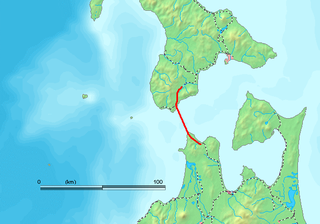
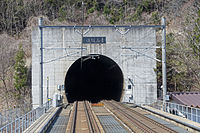
The Seikan Tunnel is a 53.85 km (33.46 mi) dual-gauge railway tunnel in Japan, with a 23.3 km (14.5 mi) portion under the seabed of the Tsugaru Strait, which separates Aomori Prefecture on the main Japanese island of Honshu from the northern island of Hokkaido. The track level is about 100 m (330 ft) below the seabed and 240 m (790 ft) below sea level. The tunnel is part of the standard-gauge Hokkaido Shinkansen and the narrow-gauge Kaikyō Line of the Hokkaido Railway Company 's Tsugaru-Kaikyō Line. The name Seikan comes from combining the on'yomi readings of the first characters of Aomori (青森), the nearest major city on the Honshu side of the strait, and Hakodate (函館), the nearest major city on the Hokkaido side.
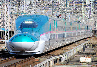
The Tōhoku Shinkansen (東北新幹線) is a Japanese high-speed Shinkansen rail line, connecting Tokyo with Aomori in Aomori Prefecture in a route length of 674.9 km (419.4 mi), making it Japan's longest Shinkansen line. It runs through the more sparsely populated Tōhoku region of Japan's main island, Honshu, and was extended as the Hokkaido Shinkansen through the Seikan Tunnel to Shin-Hakodate-Hokuto and is expected to be extended to Sapporo by 2030. It has two Mini-shinkansen branch lines, the Yamagata Shinkansen and Akita Shinkansen. The line is operated by East Japan Railway Company.

The Yamagata Shinkansen (山形新幹線) is a Mini-shinkansen route in Japan, operated by East Japan Railway Company. It provides service between Tokyo and Shinjō in Yamagata Prefecture over the tracks of the Tohoku Shinkansen and the Ōu Main Line.

The Tokyo Bay Aqua-Line, also known as the Trans-Tokyo Bay Expressway, is an expressway that is mainly made up of a bridge–tunnel combination across Tokyo Bay in Japan. It connects the city of Kawasaki in Kanagawa Prefecture with the city of Kisarazu in Chiba Prefecture, and forms part of National Route 409. With an overall length of 23.7 km, it includes a 4.4 km bridge and 9.6 km tunnel underneath the bay—the fourth-longest underwater tunnel in the world.
Fukushima is a town located in Oshima Subprefecture, Hokkaido, Japan.

The Kan-Etsu Expressway is a national expressway in Japan. It is owned and managed by East Nippon Expressway Company.
Tunnel warfare involves war being conducted in tunnels and other underground cavities. It often includes the construction of underground facilities in order to attack or defend, and the use of existing natural caves and artificial underground facilities for military purposes. Tunnels can be used to undermine fortifications and slip into enemy territory for a surprise attack, while it can strengthen a defense by creating the possibility of ambush, counterattack and the ability to transfer troops from one portion of the battleground to another unseen and protected. Also, tunnels can serve as shelter from enemy attack.
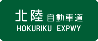
The Hokuriku Expressway, (abbreviated as Hokuriku Expwy, is a 4-laned national expressway in Japan. It is owned and managed by East Nippon Expressway Company and Central Nippon Expressway Company.
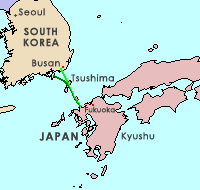
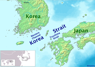
The Japan–Korea Undersea Tunnel, or Korea–Japan Undersea Tunnel, is a proposed tunnel project to connect Japan with South Korea via an undersea tunnel crossing the Korea Strait that would use the strait islands of Iki and Tsushima, a straight-line distance of approximately 128 kilometers (80 mi) at its shortest.

National Route 291 is a national highway of Japan connecting Maebashi, Gunma and Kashiwazaki, Niigata in Japan, with a total length of 161.6 km (100.41 mi).
National Route 410 is a national highway located entirely within Chiba Prefecture, Japan. It connects the cities of Tateyama and Kisarazu, spanning the Bōsō Peninsula in a south–north routing. The highway has a total length of 110.4 kilometers (68.6 mi).

The Michinoku Toll Road is a two-lane toll road in Aomori Prefecture connecting the cities Aomori and Hachinohe via Shichinohe. It serves as an alternative to Japan National Route 4, bypassing the towns Hiranai and Noheji by cutting directly through the Hakkōda Mountains and other mountains of the northern Ōu Mountain Range. The road is managed by the Aomori Prefecture Road Corporation and is numbered E4A as an extension of the Tōhoku Expressway.