List on Sylt

Last updated
List auf Sylt
List auf Sylt Luftbild.jpg
Flagge List auf Sylt.svg
DEU List auf Sylt COA.svg
Location of List auf Sylt within Nordfriesland district
List in NF.PNG
Germany adm location map.svg
Red pog.svg
List auf Sylt
Germany Schleswig-Holstein adm location map.svg
Red pog.svg
List auf Sylt
Coordinates: 55°0′N8°26′E / 55.000°N 8.433°E / 55.000; 8.433
Country Germany
State Schleswig-Holstein
District Nordfriesland
Municipal assoc. Landschaft Sylt
Government
   Mayor Wolfgang Strenger
Area
  Total18.47 km2 (7.13 sq mi)
Elevation
3 m (10 ft)
Population
 (2021-12-31) [1]
  Total1,557
  Density84/km2 (220/sq mi)
Time zone UTC+01:00 (CET)
  Summer (DST) UTC+02:00 (CEST)
Postal codes
25992
Dialling codes 04651
Vehicle registration NF
Website www.amtlandschaftsylt.de

List auf Sylt (known as List until 31 December 2008 [2] ) is the northernmost municipality in Germany, located on the North Sea island of Sylt close to Denmark in the district of Nordfriesland in the state of Schleswig-Holstein.

Contents

Etymology

List derived from the Middle Low German Liste (ledge, bar or edge). [3] :230

History

List was originally a Danish settlement. It was first mentioned in 1292 (Lystum). The original village was destroyed by the great flood of 1364. The settlement was rebuilt further east from the previous location. In the mid-15th century, a church named St. Jürgen was mentioned. In a treaty of 1460, Schleswig and Holstein were linked to the Danish crown, but List remained part of the royal enclaves, small areas of the Kingdom of Denmark situated within the Duchy of Schleswig, but directly controlled by the Danish king. [4]

From the 16th century, the people of List mostly made a living from oyster farming, raising sheep and collecting and selling gull eggs. At the time, List was an important protective anchorage. In 1644, a Swedish-Dutch fleet of 26 ships commanded by Admiral Thijssen was attacked in the Lister Tief and defeated by Danish ships commanded by king Christian IV of Denmark. The anchorage north of today's town was named Königshafen to honour this event. [3] :231 [4]

After the Danish-German war of 1864, List became part of Prussia. In 1908, List had 13 houses and 70 inhabitants. [3] :231

The plebiscite of 1920 drew the border just north of List, with the next island (Rømø) being returned to Denmark.

In World War I, List became a naval air base. The first fortifications were constructed in 1914, followed by a hangar for naval planes. [4] In 1927, a station of the Deutsche Verkehrsfliegerschule opened in List. This served both to train civilian pilots (for Lufthansa) as well as providing training for military purposes, officially forbidden by the Treaty of Versailles. [4]

Much of today's town was built in the 1930s, when the Nazis expanded their military installations and added housing for military personnel. [5] The current church of St. Jürgen was built. [4] The population increased from 449 in 1933 to 3,000 by 1939, excluding military personnel. [3] :231

After the end of World War II, the small town of List had to house around 2,000 displaced Germans, including 15 families from Heligoland, occupied by the British. The hangar was dismantled and transported to Kiel, where it became the Ostseehalle. In 1955, the Bundeswehr was established and the navy (Bundesmarine) returned to List. [3] :231

More recently, the military presence was withdrawn from the area, shifting the focus of List's economy more and more towards the tourist industry. [5] The Marineversorgungsschule  [ de ] closed at the end of 2006, ending the long period in which the military had been a major influence and the town's largest employer. [4]

Geography

List is the northernmost municipality of Germany, located at the northern part of the island of Sylt. The village is surrounded by dunes and heath, most of them protected nature reserves. To the north of List is the "Ellenbogen", a peninsula in the shape of an elbow (hence its name). To the west is the only shifting sand dune in Germany. [5]

7/8ths of the area is private property owned by a group of 30 descendants of the original landowners, first mentioned in 1608. [5]

Climate

Climate data for List on Sylt (1991–2020 normals)
MonthJanFebMarAprMayJunJulAugSepOctNovDecYear
Average high °C (°F)4.1
(39.4)
4.0
(39.2)
6.5
(43.7)
11.2
(52.2)
15.1
(59.2)
17.9
(64.2)
20.4
(68.7)
20.7
(69.3)
17.5
(63.5)
12.9
(55.2)
8.3
(46.9)
5.5
(41.9)
12.0
(53.6)
Daily mean °C (°F)2.5
(36.5)
2.3
(36.1)
4.0
(39.2)
7.8
(46.0)
11.6
(52.9)
14.7
(58.5)
17.2
(63.0)
17.6
(63.7)
14.8
(58.6)
10.7
(51.3)
6.6
(43.9)
3.8
(38.8)
9.5
(49.1)
Average low °C (°F)0.7
(33.3)
0.5
(32.9)
2.0
(35.6)
5.0
(41.0)
8.8
(47.8)
12.0
(53.6)
14.6
(58.3)
15.1
(59.2)
12.6
(54.7)
8.7
(47.7)
4.7
(40.5)
2.0
(35.6)
7.2
(45.0)
Average precipitation mm (inches)50.1
(1.97)
39
(1.5)
37.5
(1.48)
31.9
(1.26)
36.2
(1.43)
50.9
(2.00)
59.1
(2.33)
90.0
(3.54)
78.1
(3.07)
84.0
(3.31)
72.8
(2.87)
63.9
(2.52)
693.4
(27.30)
Average precipitation days (≥ 1.0 mm)18.415.514.512.512.413.414.416.416.619.419.819.2192.5
Average snowy days (≥ 1.0 cm)5.04.72.000000000.42.414.5
Average relative humidity (%)89.688.085.079.075.977.076.776.879.883.487.589.382.3
Mean monthly sunshine hours 50.775.3137.3199.4252.1232.0238.4215.6154.5104.253.342.71,755.6
Source: World Meteorological Organization [6]

Subdivisions

List has the Ortsteile Klappholtal, Mellhörn, Möwenberg, Süderheidertal and Westerheide. [3] :230

Demographics

Out of roughly 2,700 inhabitants, only around 1,600 are permanent residents, the remainder being owners of holiday homes. [5]

Economy

The economy is dominated by tourism. [5] List has been a designated Nordseebad since 1946. List is the location of the only commercial oyster farm in Germany. [3] :231

Attractions

35 meter high Ferris wheel Sylter Rad.jpg
35 meter high Ferris wheel

The Erlebniszentrum Naturgewalten, opened in 2009, features an exhibit on the powers of sea, wind and sand that have shaped the island as well as on local flora and fauna. [7]

In May 2017, a 35 meter high Ferris wheel was erected in the harbor for the 725th anniversary of the municipality of List.

Government

Until 2004, List was amtsfrei but since then has been part of the Amt Landschaft Sylt , a collective administrative body. [5] The Bürgermeister (mayor) of List is Wolfgang Strenger. [8]

Infrastructure

Transport

There is a ferry from List to the Danish island of Rømø, active since 1963. One single road leads south to the island's main town of Westerland.

List was connected to the rest of Sylt by the Sylter Nordbahn ( a narrow gauge railway) from 1908 to 1970, when it was discontinued.

There are two lighthouses in the area, List West  [ de ] and Leuchtturm List Ost  [ de ]. These are the two northernmost lighthouses in Germany. [9] [10]

Education

List has two kindergartens: a German one, and a Danish one. [5]

List hosts a facility of the Alfred Wegener Institute for Polar and Marine Research that studies the Wadden Sea.

Notable people

Related Research Articles

<span class="mw-page-title-main">Sylt</span> German island in the North Sea

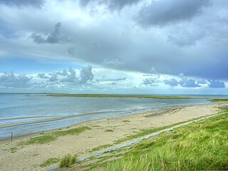
Sylt is a former island in northern Germany, part of Nordfriesland district, Schleswig-Holstein, and well known for the distinctive shape of its shoreline. It belongs to the North Frisian Islands and is the largest island in North Frisia. The northernmost island of Germany, it is known for its tourist resorts, notably Westerland, Kampen and Wenningstedt-Braderup, as well as for its 40-kilometre-long (25-mile) sandy beach. It is frequently covered by the media in connection with its exposed situation in the North Sea and its ongoing loss of land during storm tides. Since 1927, Sylt has been connected to the mainland by the Hindenburgdamm causeway. In later years, it has been a resort for the German jet set and tourists in search of occasional celebrity sightings.

<span class="mw-page-title-main">Nordfriesland (district)</span> District in Schleswig-Holstein, Germany

Nordfriesland, also known as North Frisia, is the northernmost district of Germany, part of the state of Schleswig-Holstein. It includes almost all of traditional North Frisia, as well as adjacent parts of the Schleswig Geest to the east and Stapelholm to the south, and is bounded by the districts of Schleswig-Flensburg and Dithmarschen, the North Sea and the Danish county of South Jutland. The district is called Kreis Nordfriesland in German, Kreis Noordfreesland in Low German, Kris Nordfraschlönj in Mooring North Frisian, Kreis Nuurdfresklun in Fering North Frisian and Nordfrislands amt in Danish.

<span class="mw-page-title-main">North Frisian Islands</span>

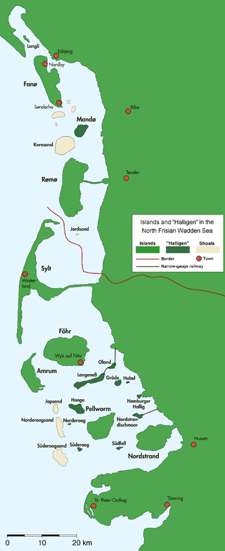
The North Frisian Islands are the Frisian Islands off the coast of North Frisia.

<span class="mw-page-title-main">Rømø</span> Danish island in the Wadden Sea

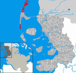
Rømø is a Danish island in the Wadden Sea. Rømø is part of Tønder Municipality. The island had 650 inhabitants as of 1 January 2011, and covers an area of 129 km².

<span class="mw-page-title-main">Wyk auf Föhr</span> Town in Schleswig-Holstein, Germany

Wyk auf Föhr is the only town on Föhr, the second largest of the North Frisian Islands on the German coast of the North Sea. Like the entire island it belongs to the district of Nordfriesland. Wyk includes the two minor town districts of Boldixum and Südstrand.

<span class="mw-page-title-main">Westerland, Germany</span> Ortsteil of Gemeinde Sylt in Schleswig-Holstein, Germany

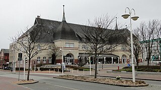
Westerland is a seaside resort and a former municipality located on the German North Sea island of Sylt. Since 1 January 2009, Westerland has been part of the municipality Gemeinde Sylt. Westerland is part of the Nordfriesland district in Schleswig-Holstein. It is the largest resort on the island, the local transportation hub and the centre of Sylt's tourist industry.

<span class="mw-page-title-main">Landschaft Sylt</span> Amt in Germany

Landschaft Sylt is an Amt in the district of Nordfriesland, in Schleswig-Holstein, Germany. It covers the island of Sylt, in the North Sea, about 65 km northwest of Husum. Its administrative seat is in the town Westerland - which is not, however, a part of the Amt.

<span class="mw-page-title-main">Klanxbüll</span> Municipality in Schleswig-Holstein, Germany

Klanxbüll is a municipality on the mainland in the northwest corner of Schleswig-Holstein, in Kreis Nordfriesland, Germany. The municipality belongs to the Amt Südtondern.

<span class="mw-page-title-main">Hörnum</span> Municipality in Schleswig-Holstein, Germany

is a municipality in the district of Nordfriesland, in Schleswig-Holstein, Germany. It is located on the southern headland of the island of Sylt. The municipality is part of the Amt Landschaft Sylt. The economy is dominated by tourism.

<span class="mw-page-title-main">Kampen (Sylt)</span> Municipality in Schleswig-Holstein, Germany

is a municipality and seaside resort on the island Sylt, in the district of Nordfriesland, in Schleswig-Holstein, Germany. It is located north of the island's main town, Westerland. The municipality is part of the AmtLandschaft Sylt. The local economy is dominated by tourism.

<span class="mw-page-title-main">Wenningstedt-Braderup</span> Municipality in Schleswig-Holstein, Germany

Wenningstedt-Braderup is a municipality and seaside resort on the island of Sylt in the district of Nordfriesland, in Schleswig-Holstein, Germany. It is located north of the town of Westerland and is part of the Amt Landschaft Sylt. The local economy is dominated by tourism.

<span class="mw-page-title-main">Dunsum</span> Municipality in Schleswig-Holstein, Germany

Dunsum is a municipality located on the western shore of Föhr in the district of Nordfriesland, in Schleswig-Holstein, Germany. It is composed of the districts of Greater and Lesser Dunsum.

<span class="mw-page-title-main">Norddorf</span> Municipality in Schleswig-Holstein, Germany

Norddorf auf Amrum is a municipality on the island of Amrum, in the district of Nordfriesland, in Schleswig-Holstein, Germany.

<span class="mw-page-title-main">Sylt-Ost</span> Municipality in Schleswig-Holstein, Germany

Sylt-Ost is a former municipality on the island of Sylt, in the district of Nordfriesland, in Schleswig-Holstein, Germany. It used to be the administrative seat of the Amt Landschaft Sylt and a municipality into which a number of villages had been amalgamated in 1970. However, following a referendum in May 2008, Sylt-Ost merged with Westerland and Rantum to form the collective municipality Gemeinde Sylt which was created on 1 January 2009. Since 2009, the seat of the Amt Landschaft Sylt has been in Westerland.

<span class="mw-page-title-main">Utersum</span> Municipality in Schleswig-Holstein, Germany

Utersum is a municipality on the island of Föhr, in the district of Nordfriesland, in Schleswig-Holstein, Germany. The municipality includes the hamlet of Hedehusum.

<span class="mw-page-title-main">Uthörn</span>

Uthörn is a small German island adjacent to the Sylt island in the district of Nordfriesland, and as such it is Germany's northernmost isle right after Sylt proper. It belongs to the List municipality.

<span class="mw-page-title-main">Sylt (municipality)</span> Municipality in Schleswig-Holstein, Germany

Gemeinde Sylt is a municipality on the island of Sylt in the district of Nordfriesland, in Schleswig-Holstein, Germany. It has around 13,000 inhabitants and covers about 60% of the area of the island.

Sylt may refer to:

<span class="mw-page-title-main">Keitum</span> Ortsteil of Gemeinde Sylt in Schleswig-Holstein, Germany

Keitum is a village on the North Sea island of Sylt in the district of Nordfriesland in Schleswig-Holstein, Germany. Today, it is an Ortsteil of the Gemeinde Sylt.

<span class="mw-page-title-main">Capture of the North Frisian Islands</span> Campaign in the 2nd Schleswig War1864

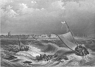
The capture of the North Frisian Islands and Rømø in July 1864 was the last military operation of the Second Schleswig War between Denmark on the one hand and Prussia and the Austrian Empire on the other hand around the duchies of Schleswig and Holstein, which belonged to Denmark. It ended with the occupation of the North Frisian Islands and Rømø by Austrian troops.

References

  1. "Bevölkerung der Gemeinden in Schleswig-Holstein 4. Quartal 2021" (XLS) (in German). Statistisches Amt für Hamburg und Schleswig-Holstein.
  2. Gebietsänderungen vom 01. Januar bis 31. Dezember 2015, Statistisches Bundesamt
  3. 1 2 3 4 5 6 7 Kunz, Harry; Steensen, Thomas (2014). Taschenlexikon Sylt (German). Wachholtz. ISBN   978-3-529-05525-6.
  4. 1 2 3 4 5 6 "Geschichtliches (German)". Kurverwaltung List. Retrieved 30 April 2015.
  5. 1 2 3 4 5 6 7 8 "Die Gemeinde List (Sylt) (German)". Amt Landschaft Sylt. Retrieved 30 April 2015.
  6. "World Meteorological Organization Climate Normals for 1991–2020". World Meteorological Organization Climatological Standard Normals (1991–2020). National Oceanic and Atmospheric Administration. Archived from the original on 12 October 2023. Retrieved 12 October 2023.
  7. "Erlebniszentrum (German)". Kurverwaltung List. Retrieved 30 April 2015.
  8. "Ansprechpartner Gemeinde List(Sylt) (German)". Amt Landschaft Sylt. Retrieved 30 April 2015.
  9. "List West (German)". WSA Tönning. Retrieved 30 April 2015.
  10. "List Ost(German)". WSA Tönning. Retrieved 30 April 2015.

Commons-logo.svg Media related to List auf Sylt at Wikimedia Commons