Listed buildings in Calverton, Nottinghamshire

Last updated

Calverton is a civil parish in the Gedling district of Nottinghamshire, England. The parish contains 17 listed buildings that are recorded in the National Heritage List for England. Of these, one is listed at Grade II*, the middle of the three grades, and the others are at Grade II, the lowest grade. The parish contains the village of Calverton and the surrounding countryside. Most of the listed buildings are houses and cottages, including former knitters' cottages. The other listed buildings include a church, a former hosiery factory and a war memorial, and, outside the village, two farmhouses and associated structures.

Contents

Key

Map all coordinates using: OpenStreetMap
GradeCriteria [1]
II*Particularly important buildings of more than special interest
IIBuildings of national importance and special interest


Buildings

Name and locationPhotographDateNotesGrade
St Wilfrid's Church
53°02′11″N1°04′50″W / 53.03640°N 1.08068°W / 53.03640; -1.08068 (St Wilfrid's Church)
St Wilfrid's Church - geograph.org.uk - 2559235.jpg
Early 13th centuryThe church has been altered and extended through the centuries, in 1760–63 the nave and tower were rebuilt, the chancel was rebuilt in 1835, and the church was restored in 1881. The church is built in stone with roofs of lead, slate and tile, and consists of a nave, a south porch, a chancel, an organ chamber, a vestry and a west tower. The tower has a single stage, two buttresses, openings with Gibbs surrounds, and a clock face on the south side. On the west side is a doorway with a fanlight, above which is a datestone and a three-light window, and at the top is an embattled parapet. The nave also has an embattled parapet. [2] [3] II*
Corner Cottage
53°02′11″N1°04′54″W / 53.03625°N 1.08160°W / 53.03625; -1.08160 (Corner Cottage)
Corner Cottage, Calverton.jpg
Late 17th centuryThe house is in brick, partly rendered, on a rendered plinth, with cogged and rebated eaves, and a pantile roof with coped gables. There are two storeys and three bays. On the front is a lean-to porch, and the windows are casements, those in the ground floor with segmental heads. [4] [5] II
14 and 16 Main Street
53°02′09″N1°04′48″W / 53.03592°N 1.07988°W / 53.03592; -1.07988 (14 and 16 Main Street)
14 and 16 Main Street, Calverton.jpg
Early 18th centuryA house divided into two houses, it is in brick with rendered gables, on a rendered plinth, with cogged eaves, and a tile roof with shouldered coped gables. There are two storeys, three bays, a lower single-bay extension on the right, and a rear lean-to. On the front are two weatherboarded gabled porches, and the windows are casements, those in the ground floor with segmental heads. [6] II
Lodge Farmhouse and stables
53°02′57″N1°05′15″W / 53.04921°N 1.08758°W / 53.04921; -1.08758 (Lodge Farmhouse and stables)
Lodge Farm - geograph.org.uk - 1759490.jpg
Early 18th centuryThe farmhouse is in brick, partly rendered, with a pantile roof. There are three storeys and an L-shaped plan, with a main range of three bays, a single-storey stable range to the left, and a rear lean-to. The central doorway has a moulded surround, and the windows in the lower two floors are sashes, the window above the doorway with a round-arched head and a keystone. In the top floor are three lunette windows. The stable range contains casement windows and doorways with segmental heads. [4] [7] II
Weaver's Cottage
53°02′09″N1°04′54″W / 53.03597°N 1.08165°W / 53.03597; -1.08165 (Weaver's Cottage)
Early 18th centuryA house in whitewashed brick with a pantile roof and coped gables. There are two storeys and three bays, and a single-storey extension to the right. On the front is a lean-to porch, and the windows are casements. [8] II
150 Main Street
53°02′17″N1°05′30″W / 53.03810°N 1.09178°W / 53.03810; -1.09178 (150 Main Street)
c. 1775A farmhouse, cartshed and stable combined into a private house, it is in brick with roofs of tile and slate. There are three storeys and an L-shaped plan with a front of three bays. In the centre of the south front is an elaborate wrought iron porch and a doorway with a fanlight and a stone hood on brackets. The windows are a mix of sashes with segmental heads and casements. On the east front is a porch and a doorway with a hood, and the openings include two altered cart openings, a blocked doorway and a stable door. [9] [10] II
18 Main Street
53°02′10″N1°04′48″W / 53.03599°N 1.08011°W
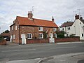
 / 53.03599; -1.08011 (18 Main Street)
18 Main Street, Calverton.jpg
Late 18th centuryA house and a cottage combined into one house, it is in brick with a pantile roof. There are two storeys, and an L-shaped plan with a front of three bays, and a later rear extension. On the front are two doorways with segmental heads, one in a gabled porch, and the windows are casements, those in the ground floor with segmental heads. [11] [12] II
135 Main Street
53°02′13″N1°05′12″W / 53.03690°N 1.08675°W / 53.03690; -1.08675 (135 Main Street)
Woods Lane, Calverton.jpg
Late 18th centuryThe house is in whitewashed brick with cogged eaves and a pantile roof. There are two storeys, four bays, and a two-bay toilet block. The doorway has a brick hood. In the north gable end is a sash window with a segmental head, and the other windows are casements, those in the ground floor with segmental heads. [13] II
Museum Cottage
53°02′13″N1°05′03″W / 53.03701°N 1.08425°W / 53.03701; -1.08425 (Museum Cottage)
Museum Cottage, Calverton.jpg
c. 1780The cottage, later a museum, is in brick on a stone plinth, with a pantile roof and coped gables. The doorway has a segmental head, and the windows are casements, some with shutters. [14] II
Hollinwood House and outbuilding
53°02′10″N1°06′33″W / 53.03599°N 1.10911°W / 53.03599; -1.10911 (Hollinwood House and outbuilding)
c. 1800The house is in brick, partly rendered, with a pantile roof, two storeys and attics. In the centre is a gabled porch, and the windows are sashes. Attached on the left is a single-storey outbuilding with a small casement window. [15] II
22 Main Street
53°02′10″N1°04′49″W / 53.03610°N 1.08030°W / 53.03610; -1.08030 (22 Main Street)
Early 19th centuryA house in whitewashed brick, it has cogged eaves, and a pantile roof with coped gables. There are two storeys and an L-shaped plan, with a front range of three bays and rear extensions. On the front is a gabled porch, and the windows are horizontally-sliding sashes, those in the ground floor with segmental heads. [16] II
Calverton House
53°02′09″N1°04′45″W / 53.03581°N 1.07918°W
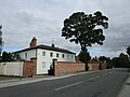
 / 53.03581; -1.07918 (Calverton House)
Calverton House, Calverton.jpg
Early 19th centuryA vicarage, later a private house, in rendered brick on a chamfered plinth, with corbelled eaves, and a roof partly hipped in slate and partly gabled in pantile. There are two storeys and an L-shaped plan. The main block has a front of six bays, and sides of two bays, and there is a rear service wing. The doorway in the west front is recessed and round-headed, and has a rebated surround and a fanlight. The windows in the main block are sashes, and in the service wing are casements and a horizontally-sliding sash. [11] [17] II
Church View
53°02′09″N1°04′51″W / 53.03582°N 1.08088°W / 53.03582; -1.08088 (Church View)
Early 19th centuryThe house is in whitewashed brick with rebated eaves and a pantile roof. There are two storeys, three bays and a rear extension. On the front is a gabled porch, and the windows are casements. [18] II
Former printing works
53°02′15″N1°05′27″W / 53.03757°N 1.09073°W / 53.03757; -1.09073 (Former printing works)
130 Main Street - geograph.org.uk - 2559141.jpg
c. 1830Originally a hosiery factory and at one time a printing works, the building is in brick with gabled and hipped pantile roofs. There are two storeys and five bays. The windows are a mix of sashes and casements, those in the ground floor with segmental heads. [11] [19] II
Windles Square
53°02′09″N1°04′34″W / 53.03577°N 1.07603°W / 53.03577; -1.07603 (Windles Square)
Calverton NG14, Notts. - geograph.org.uk - 3485115.jpg
1834Two rows of knitters' cottages at right angles, later eight houses, in brick, partly rendered, with corbelled eaves and pantile roofs. There are two storeys, and each row has ten bays. In the ground floor are small lights, doorways with segmental heads, and knitters' windows with segmental heads. The upper floor contains casement windows. [11] [20] II
221 and 225 Main Street
53°02′17″N1°05′33″W / 53.03794°N 1.09250°W / 53.03794; -1.09250 (221 and 225 Main Street)
215 and 221 Main Street - geograph.org.uk - 2559128.jpg
1857Three knitters' cottages, later two houses, they are in brick with cogged eaves and a pantile roof. There are two storeys and six bays, and a single-storey extension to the left. In the ground floor are small windows and large knitters' windows with segmental heads, and the upper floor contains casement windows. In the north gable end are initials and the date in burnt brick headers. [11] [21] II
War memorial
53°02′28″N1°04′57″W / 53.04098°N 1.08260°W / 53.04098; -1.08260 (War memorial)
c. 1920The war memorial is in Calverton Cemetery. It is in granite, and consists of a wheel-head cross on a tapering plinth on a base of three steps, and is about 3.5 metres (11 ft) high. There are inscriptions on the shaft, on the four sides of the plinth and on the front face of the steps. On the other faces of the steps are the names of those lost in the two World Wars. The monument is in a square enclosure surrounded by a low wall with an iron post and a chain link fence. [22] II

Related Research Articles

Bradmore is a civil parish in the Rushcliffe district of Nottinghamshire, England. The parish contains 19 listed buildings that are recorded in the National Heritage List for England. All the listed buildings are designated at Grade II, the lowest of the three grades, which is applied to "buildings of national importance and special interest". The parish contains the village of Bradmore and the surrounding area, and all the listed buildings are in the village. The village buildings were largely destroyed by a fire in 1705, including the body of the church, but its tower and spire survived and are listed. Following the fire, Sir Thomas Parkyns of Bunny Hall, designed new buildings for the village, many of which are listed, and these include houses, farmhouses and farm buildings. The other listed buildings include a chapel and a telephone kiosk.

Car Colston is a civil parish in the Rushcliffe district of Nottinghamshire, England. The parish contains 14 listed buildings that are recorded in the National Heritage List for England. Of these, one is listed at Grade I, the highest of the three grades, and the others are at Grade II, the lowest grade. The parish contains the village of Car Colston and the surrounding countryside. Most of the listed buildings are houses and associated structures, and the others include a church, headstones in the churchyard, and a whipping post.

East Leake is a civil parish in the Rushcliffe district of Nottinghamshire, England. The parish contains 14 listed buildings that are recorded in the National Heritage List for England. Of these, one is listed at Grade I, the highest of the three grades, and the others are at Grade II, the lowest grade. The parish contains the village of East Leake and the surrounding countryside. The listed buildings consist of houses, cottages and farmhouses, two churches, a chest tomb in a churchyard, a water house, a pinfold, and a war memorial.

Eaton is a civil parish in the Bassetlaw District of Nottinghamshire, England. The parish contains six listed buildings that are recorded in the National Heritage List for England. All the listed buildings are designated at Grade II, the lowest of the three grades, which is applied to "buildings of national importance and special interest". The parish contains the village of Eaton and the surrounding area. All the listed buildings are in the village, and consist of two cottages, two farmhouses, a school and a church.

Gedling is a local government district with borough status in Nottinghamshire. This list contains the 34 listed buildings that are recorded in the National Heritage List for England in the parts of the borough that are unparished. Of these, one is listed at Grade I, the highest of the three grades, three are at Grade II*, the middle grade, and the others are at Grade II, the lowest grade. The list includes communities in Arnold, Carlton, Daybrook and Redhill. Most of the listed buildings are houses, cottages, and associated structures, farmhouses and farm buildings. The others include churches and associated structures, buildings associated with the framework-knitting and hosiery industry, almshouses, war memorials, shops and a former public house.

Greasley is a civil parish in the Borough of Broxtowe, Nottinghamshire, England. The parish contains 30 listed buildings that are recorded in the National Heritage List for England. Of these, two are listed at Grade II*, the middle of the three grades, and the others are at Grade II, the lowest grade. The parish contains the settlements of Beauvale, Moorgreen and Watnall and the surrounding area. Most of the listed buildings are houses, cottages and associated structures, farmhouses and farm buildings. The others include the remains of a fortified manor house, a church and a former chapel, and a school.

Kirklington is a civil parish in the Newark and Sherwood district of Nottinghamshire, England. The parish contains 13 listed buildings that are recorded in the National Heritage List for England. Of these, one is listed at Grade II*, the middle of the three grades, and the others are at Grade II, the lowest grade. The parish contains the village of Kirklington and the surrounding countryside. All the listed buildings are in the village, and consist of houses, cottages, farmhouses and farm buildings, a church, a school, a village hall, a water mill and an adjoining road bridge, and a telephone kiosk.

Kneeton is a civil parish in the Rushcliffe district of Nottinghamshire, England. The parish contains ten listed buildings that are recorded in the National Heritage List for England. All the listed buildings are designated at Grade II, the lowest of the three grades, which is applied to "buildings of national importance and special interest". The parish contains the village of Kneeton and the surrounding area. All the listed buildings are in the village, and consist of a church, headstones in the churchyard, houses, cottages and associated structures, farmhouses and farm buildings.

Lambley is a civil parish in the Gedling district of Nottinghamshire, England. The parish contains seven listed buildings that are recorded in the National Heritage List for England. Of these, one is listed at Grade I, the highest of the three grades, and the others are at Grade II, the lowest grade. The parish contains the village of Lambley and the surrounding countryside, and the listed buildings consist of a church, houses and cottages, and a farmhouse with a stable.

Linby is a civil parish in the Gedling district of Nottinghamshire, England. The parish contains 27 listed buildings that are recorded in the National Heritage List for England. Of these, two are listed at Grade II*, the middle of the three grades, and the others are at Grade II, the lowest grade. The parish contains the village of Linby and the surrounding countryside. Most of the listed buildings are houses, cottages and associated structures, farmhouses and farm buildings. The others include a church, a headstone in the churchyard, two village crosses, a water mill, two boundary markers and a telephone kiosk.

Norwell is a civil parish in the Bassetlaw District of Nottinghamshire, England. The parish contains 17 listed buildings that are recorded in the National Heritage List for England. Of these, one is listed at Grade I, the highest of the three grades, and the others are at Grade II, the lowest grade. The parish contains the village of Norwell and the surrounding area, and all the listed buildings are in the village. Most of these are houses, cottages, and associated structures, farmhouses and farm buildings. The others include a church and associated structures, an animal pound, a former windmill and a war memorial.

Orston is a civil parish in the Rushcliffe district of Nottinghamshire, England. The parish contains nine listed buildings that are recorded in the National Heritage List for England. Of these, one is listed at Grade I, the highest of the three grades, and the others are at Grade II, the lowest grade. The parish contains the village of Orston and the surrounding area. All the listed buildings are in the village, and consist of houses, farmhouses and associated structures, and a church.

Papplewick is a civil parish in the Gedling district of Nottinghamshire, England. The parish contains 32 listed buildings that are recorded in the National Heritage List for England. Of these, two are listed at Grade I, the highest of the three grades, one is at Grade II*, the middle grade, and the others are at Grade II, the lowest grade. The parish contains the village of Papplewick and the surrounding countryside. Most of the listed buildings are in the village, and they consist of a church and items in the churchyard, a country house and associated structures, houses, cottages and associated structures, farmhouses and farm buildings, and a public house. In the eastern part of the parish is Papplewick Pumping Station, which contains a number of listed buildings. Elsewhere, two boundary stones and two commemorative obelisks are listed.

South Muskham is a civil parish in the Newark and Sherwood district of Nottinghamshire, England. The parish contains nine listed buildings that are recorded in the National Heritage List for England. Of these, one is listed at Grade I, the highest of the three grades, two are at Grade II*, the middle grade, and the others are at Grade II, the lowest grade. The parish contains the villages of South Muskham and Little Carlton, and the surrounding area. The listed buildings consist of a church and associated structures, farmhouses and farm buildings, cottages, two viaducts and a road bridge.

Stanford on Soar is a civil parish in the Rushcliffe district of Nottinghamshire, England. The parish contains 15 listed buildings that are recorded in the National Heritage List for England. Of these, one is listed at Grade I, the highest of the three grades, one is at Grade II*, the middle grade, and the others are at Grade II, the lowest grade. The parish contains the village of Stanford on Soar and the surrounding area. The largest building in the parish is Stanford Hall, which is listed together with associated buildings. The other listed buildings are in or near the village, and consist of a church, its lych gate, a farmhouse and barns, a packhorse bridge, and two rows of estate cottages.

Trowell is a civil parish in the Borough of Broxtowe, Nottinghamshire, England. The parish contains nine listed buildings that are recorded in the National Heritage List for England. Of these, one is listed at Grade II*, the middle of the three grades, and the others are at Grade II, the lowest grade. The parish contains the village of Trowell and the surrounding countryside. The Nottingham Canal passes through the parish, and two bridges crossing it are listed. The other listed buildings consist of a church, a country house, smaller houses and associated structures, and a farmhouse and farm buildings.

Upton is a civil parish in the Newark and Sherwood district of Nottinghamshire, England. The parish contains 24 listed buildings that are recorded in the National Heritage List for England. Of these, one is listed at Grade I, the highest of the three grades, two are at Grade II*, the middle grade, and the others are at Grade II, the lowest grade. The parish contains the village of Upton and the surrounding countryside. To the east of the parish is a former workhouse, which is listed together with its infirmary. The other listed buildings are in the village, and consist of a church, headstones in the churchyard, a former country house and its gateway, smaller houses, cottages, farmhouses, and associated structures, a public house and a telephone kiosk.

Warsop is a civil parish in the Mansfield District of Nottinghamshire, England. The parish contains 28 listed buildings that are recorded in the National Heritage List for England. Of these, two are listed at Grade I, the highest of the three grades, one is at Grade II*, the middle grade, and the others are at Grade II, the lowest grade. The parish contains the town of Warsop, the settlements of Church Warsop and Sookholme, and the surrounding countryside. Most of the listed buildings are houses, cottages and associated structures, farmhouses and farm buildings. The other listed buildings include two churches with associated structures, a parish centre converted from an old courtyard house, a public house, a bridge and a weir, a watermill, a windmill, and a war memorial.

Willoughby on the Wolds is a civil parish in the Rushcliffe district of Nottinghamshire, England. The parish contains six listed buildings that are recorded in the National Heritage List for England. Of these, one is listed at Grade I, the highest of the three grades, and the others are at Grade II, the lowest grade. The parish contains the village of Willoughby on the Wolds and the surrounding area. All the listed buildings are in the village, and they consist of a church, houses, cottages and farmhouses, and associated structures.

Woodborough is a civil parish in the Gedling district of Nottinghamshire, England. The parish contains 16 listed buildings that are recorded in the National Heritage List for England. Of these, two are listed at Grade II*, the middle of the three grades, and the others are at Grade II, the lowest grade. The parish contains the village of Woodborough and the surrounding area. All the listed buildings are in the village, and consist of a church, houses, cottages and associated structures, including two water pumps, and a telephone kiosk.

References

Citations

Sources