Crooklands is a village in South Lakeland, Cumbria, England, 4.5 miles (7.2 km) south of Kendal on the A65 road. Historically part of Westmorland, the Lancaster Canal and Peasey Beck pass through Crooklands. The adjacent showfield of the Westmorland County Agricultural Society is the venue of the annual Westmorland County Show, Country Fest and various other events.
Moston is a civil parish in Cheshire East, England. It contains 16 buildings that are recorded in the National Heritage List for England as designated listed buildings, all of which are at Grade II. This grade is the lowest of the three gradings given to listed buildings and is applied to "buildings of national importance and special interest". The parish contains the village of Moston Green, but is otherwise mainly rural. The Trent and Mersey Canal runs through the parish, and eight of the listed buildings are associated with it, namely bridges, locks, and mileposts. The other listed buildings are farmhouses, farm buildings, a cottage, a club that was originally a farmhouse, and a turnpike milepost.
Borwick is a civil parish in Lancaster, Lancashire, England. It contains 27 listed buildings that are recorded in the National Heritage List for England. Of these, three are listed at Grade I, the top grade, and the others are at Grade II, the lowest of the three grades of listing. The parish contains the village of Borwick, and is otherwise rural. The most important building in the parish is Borwick Hall; this and a number of associated buildings and structures are listed. The Lancaster Canal passes through the parish, and associated with it are five listed bridges and an aqueduct. The other listed buildings include houses, farm buildings, bridges over the River Keer, a church, a milestone, and a telephone kiosk.
Carnforth is a civil parish in Lancaster, Lancashire, England. It contains 20 listed buildings that are recorded in the National Heritage List for England. Of these, three are at Grade II*, the middle grade, and the others are at Grade II, the lowest grade. Until the coming of the railway in the middle of the 19th century the parish contained what was then the village of Carnforth, and was otherwise rural. By the later part of the century it had become an important railway junction, linking the south of England with Carlisle, Barrow-in-Furness, and Leeds. There are seven listed buildings associated with the railway and, in addition, a signal box moved from another site. The Lancaster Canal passes through the parish, and two bridges crossing it are listed. The other listed buildings include houses, a farmhouse, a farm building, a public house, a church, and a milestone.
Ellel is a civil parish in Lancaster, Lancashire, England. It contains 46 listed buildings that are recorded in the National Heritage List for England. Of these, one is listed at Grade II*, the middle grade, and the others are at Grade II. The parish contains the villages of Galgate and Dolphinholme, and is otherwise rural. A high proportion of the listed buildings are country houses, smaller houses and cottages, farmhouses and farm buildings. In the 18th and 19th centuries silk spinning took place in Galgate, and two silk mills, later converted for other uses, are listed. The Lancaster Canal passes through the parish, and the junction with its Glasson Branch is also in the parish. Associated with these are listed bridges, locks, and an aqueduct. Bridges over the Rivers Wyre and Conder are also listed. Other listed buildings include a public house, churches and structures in churchyards, a milestone, a war memorial. and boundary stones.
Yealand Redmayne is a civil parish in Lancaster, Lancashire, England. It contains 15 buildings that are recorded in the National Heritage List for England as designated listed buildings. Of these, one is at Grade II*, the middle grade, and the others are at Grade II, the lowest grade. The parish contains the village of Yealand Redmayne, and is otherwise rural. Most of the listed buildings are houses, farmhouses and farm buildings, many of them on the main street of the village. The Lancaster Canal passes through the parish, and two bridges crossing it are listed, together with a milestone on its towpath.
Barton is a civil parish in the City of Preston, Lancashire, England. It contains ten listed buildings that are recorded in the National Heritage List for England. Of these, one is at Grade II*, the middle grade, and the others are at Grade II, the lowest grade. The parish contains the village of Barton and surrounding countryside. Running through it is the Lancaster Canal, and a bridge crossing it and an aqueduct are listed. The other listed buildings include farm buildings, milestones, a church, and a cross.
Catterall is a civil parish in the Wyre district of Lancashire, England. It contains eight listed buildings that are recorded in the National Heritage List for England. All the listed buildings are designated at Grade II, the lowest of the three grades, which is applied to "buildings of national importance and special interest". The parish includes the village of Catterall and the surrounding countryside. The Lancaster Canal and the River Calder run through the parish, and the listed buildings associated with these are bridges and an aqueduct. The other listed buildings are two medieval cross bases, a farmhouse with an associated barn, and a milestone.
Myerscough and Bilsborrow is a civil parish in the Wyre district of Lancashire, England. It contains 15 listed buildings that are recorded in the National Heritage List for England. All the listed buildings are designated at Grade II, the lowest of the three grades, which is applied to "buildings of national importance and special interest". The parish contains the village of Bilsborrow, the hamlet of Myerscough, and the surrounding countryside. The Lancaster Canal and the River Brock pass through the parish. Five bridges over the canal and two over the river are listed, together with the aqueduct carrying the canal over the river. The other listed buildings include farmhouses and a farm building, entrance piers and walls, a milestone, a boundary stone, and a country house.
Beetham is a civil parish in the South Lakeland District of Cumbria, England. It contains 47 listed buildings that are recorded in the National Heritage List for England. Of these, two are listed at Grade I, the highest of the three grades, four are at Grade II*, the middle grade, and the others are at Grade II, the lowest grade. The parish contains the villages of Beetham, Farleton and Hazelslack, and the surrounding countryside. The Lancaster Canal passes through the parish, and the listed buildings associated with this are bridges, an aqueduct and a milestone. Most of the listed buildings in the parish are houses, some of them originally tower houses, and associated structures, farmhouses and farm buildings. The other listed buildings consist of a church, bridges, a former corn mill, milestones and a milepost, boundary stones and a boundary post, a former school, a signal box, and a war memorial.
Burton-in-Kendal is a civil parish in the South Lakeland District of Cumbria, England. It contains 32 listed buildings that are recorded in the National Heritage List for England. Of these, one is listed at Grade I, the highest of the three grades, one is at Grade II*, the middle grade, and the others are at Grade II, the lowest grade. The parish contains the village of Burton-in-Kendal and the surrounding countryside. The Lancaster Canal passes through the parish, and the listed buildings associated with this are a bridge, an aqueduct, and a milestone. The other listed buildings are located in the village, apart from two boundary stones, a milestone, and a farmhouse. In the village, the listed buildings include houses and associated structures, a church and items in the churchyard, hotels, public houses, a market cross, and a commemorative lamp post.
Helsington is a civil parish in the South Lakeland District of Cumbria, England. It contains 21 listed buildings that are recorded in the National Heritage List for England. Of these, one is listed at Grade I, the highest of the three grades, one is at Grade II*, the middle grade, and the others are at Grade II, the lowest grade. The parish includes the village of Brigsteer, and is otherwise rural. The major listed buildings in the parish are Sizergh Castle and associated structures. The other listed buildings include farmhouses, farm buildings, houses, bridges, a church, a snuff mill, and buildings associated with a former gunpowder works.
Hincaster is a civil parish in the South Lakeland District of Cumbria, England. It contains eleven listed buildings that are recorded in the National Heritage List for England. Of these, one is listed at Grade II*, the middle of the three grades, and the others are at Grade II, the lowest grade. The parish contains the village of Hincaster and the surrounding countryside. The Lancaster Canal passed through the parish, including the Hincaster Tunnel. This part of the canal is now dry, but structures associated with it are listed, including the portals of the tunnel, a cottage, and accommodation bridges and a railway bridge crossing the canal or the sunken horse path. The other listed buildings are farmhouses and farm buildings.
Holme is a civil parish in the South Lakeland District of Cumbria, England. It contains 14 listed buildings that are recorded in the National Heritage List for England. All the listed buildings are designated at Grade II, the lowest of the three grades, which is applied to "buildings of national importance and special interest". The parish contains the village of Holme and the surrounding countryside. The Lancaster Canal passes through the parish, and nine structures on the canal are listed, eight bridges and a milepost. The other listed buildings are a house, a farmhouse, two boundary stones, and a milepost on a road.
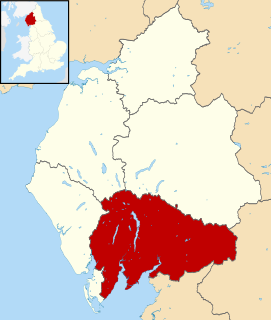
Kendal is a civil parish in the South Lakeland District of Cumbria, England. It contains 187 listed buildings that are recorded in the National Heritage List for England. Of these, three are listed at Grade I, the highest of the three grades, twelve are at Grade II*, the middle grade, and the others are at Grade II, the lowest grade. The parish contains the market town of Kendal, and its surroundings. The major industries historically were wool, weaving and dyeing, and snuff is still made in the town. The Lancaster Canal came to the town in 1819, and this created new industries, including a large shoe and boot factory.
Natland is a civil parish in the South Lakeland District of Cumbria, England. It contains 14 listed buildings that are recorded in the National Heritage List for England. Of these, one is listed at Grade II*, the middle of the three grades, and the others are at Grade II, the lowest grade. The parish contains the village of Natland, and is otherwise rural. The listed buildings include houses, farmhouses, farm buildings, bridges, a church, a milestone, and a boundary post.
Preston Patrick is a civil parish in the South Lakeland District of Cumbria, England. It contains 24 listed buildings that are recorded in the National Heritage List for England. Of these, one is listed at Grade II*, the middle of the three grades, and the others are at Grade II, the lowest grade. The parish contains the villages of Preston Patrick and Crooklands, and is otherwise mainly rural. The Lancaster Canal passes through the parish, and the listed buildings associated with it are bridges, an aqueduct, and milestones. The other listed buildings consist of houses and associated structures, farmhouses, farm buildings, boundary stones, milestones on roads, and a church.
Sedgwick is a civil parish in the South Lakeland District of Cumbria, England. It contains five listed buildings that are recorded in the National Heritage List for England. All the listed buildings are designated at Grade II, the lowest of the three grades, which is applied to "buildings of national importance and special interest". The parish contains the village of Sedgwick and the surrounding countryside. The Lancaster Canal passed through the parish, but it now dry in this area; There are two listed buildings associated with it, an aqueduct and a bridge. The other listed buildings are a farmhouse, and a former country house and its gatehouse.
Stainton is a civil parish in the South Lakeland District of Cumbria, England. It contains eleven listed buildings that are recorded in the National Heritage List for England. All the listed buildings are designated at Grade II, the lowest of the three grades, which is applied to "buildings of national importance and special interest". The parish contains the village of Stainton, and is otherwise rural. The Lancaster Canal passes through the parish and a number of structures associated with it are listed. The other listed buildings include a farmhouse, a packhorse bridge, a church, a boundary stone, a boundary post, and a milestone.
Weston Rhyn is a civil parish in Shropshire, England. It contains 21 listed buildings that are recorded in the National Heritage List for England. Of these, three are listed at Grade II*, the middle of the three grades, and the others are at Grade II, the lowest grade. The parish contains the village of Weston Rhyn and the surrounding countryside. The Llangollen Canal passes through the parish and the listed structures associated with it are an aqueduct and a road bridge. Many of the other listed buildings are houses and associated structures, farmhouses and farm buildings, the earliest of which are timber framed or have timber framed cores. The other listed buildings include a road bridge, two sets of limekilns, three milestones, a bee bole, a viaduct, a folly in the form of a stone circle, a church, a Sunday school, and a war memorial.