Listed buildings in Unstone

Last updated

Unstone is a civil parish in the North East Derbyshire district of Derbyshire, England. The parish contains 15 listed buildings that are recorded in the National Heritage List for England. Of these, two are listed at Grade II*, the middle of the three grades, and the others are at Grade II, the lowest grade. The parish contains the villages of Unstone, Apperknowle and West Handley and smaller settlements, and is otherwise rural. Apart from a railway viaduct, all the listed buildings are houses, cottages and associated structures, farmhouses, and farm buildings.

Contents

Key

Map all coordinates using: OpenStreetMap
GradeCriteria [1]
II*Particularly important buildings of more than special interest
IIBuildings of national importance and special interest

Buildings

Name and locationPhotographDateNotesGrade
Ash Lane Farmhouse
53°17′44″N1°24′17″W / 53.29546°N 1.40475°W / 53.29546; -1.40475 (Ash Lane Farmhouse)
Ash Lane Farmhouse, West Handley - geograph.org.uk - 3179854.jpg
Late 16th centuryThe farmhouse is cruck framed, with walls of sandstone and a thatched roof. There is a single storey and attics, and three bays. In the centre is a lean-to porch, the windows are casements, and there are three eyebrow dormers. Inside, there are three cruck trusses. [2] [3] II
The Old Barns
53°17′43″N1°24′16″W / 53.29517°N 1.40449°W / 53.29517; -1.40449 (The Old Barns)
Late 16th centuryTwo farm outbuildings linked and converted into a house in 1984. The building is in sandstone with quoins and has a Welsh slate roof with stone slate eaves. The south range has two storeys and three bays, and a central doorway between enlarged slit vents. The north range, at right angles, is earlier, and has a single storey and three bays. It contains two complete cruck trusses, and the remains of a third. [2] [4] II
Summerley Farmhouse
53°18′17″N1°26′30″W / 53.30477°N 1.44154°W / 53.30477; -1.44154 (Summerley Farmhouse)
Summerley Farmhouse, Summerley - geograph.org.uk - 2836553.jpg
1605The farmhouse is in sandstone with quoins, and a stone slate roof with coped gables and moulded kneelers. There are two storeys and two bays. The doorway has a massive quoined surround, an initialled and dated lintel and a hood mould. The windows are mullioned, with four lights in the ground floor, three lights in the upper floor, and hood moulds. [2] [5] II
The Farm
53°17′59″N1°25′58″W / 53.29960°N 1.43266°W / 53.29960; -1.43266 (The Farm)
Early 17th centuryA farmhouse in sandstone with quoins and a slate roof. There are two storeys and an L-shaped plan, with a front range of two bays and a rear extension. In the centre are two doorways, and the windows are mullioned with casements and hood moulds. At the southwest end is a blocked doorway with a quoined surround and a massive lintel. In the angle at the rear is a semicircular stair tower. [6] II
Summerley Hall, walls and gate piers
53°18′17″N1°26′32″W / 53.30462°N 1.44217°W / 53.30462; -1.44217 (Summerley Hall, walls and gate piers)
Early 17th centuryThe house is in sandstone with quoins, a parapet, and a tile roof with coped gables. There are two storeys, a double depth plan, a front range of two bays, and rear wings. The central doorway has a chamfered quoined surround, and a massive lintel, and the windows on the front are mullioned and transomed. At the rear is a semicircular stair tower. The front garden is enclosed by a wall that contains square gate piers with projecting moulded caps. [2] [7] II
West Handley Hall
53°17′36″N1°24′14″W / 53.29334°N 1.40378°W / 53.29334; -1.40378 (West Handley Hall)
Early 17th centuryThe house is in sandstone with quoins, and a stone slate roof with coped gables and moulded shell kneelers. There are two storeys and attics, and a T-shaped plan, with a front range of two bays flanked by single-storey wings, and a rear stair tower. The doorway has a massive surround and lintel, to the left is a four-light mullioned window, and above them is a continuous hood mould, with two-light mullioned windows in the upper floor. The west wing contains a casement window and a doorway with a plain surround. [2] [8] II*
Unstone Manor House
53°17′32″N1°26′50″W / 53.29209°N 1.44723°W / 53.29209; -1.44723 (Unstone Manor House)
Unstone - Unstone Manor House - 20220903083522.jpg
1663The house is in sandstone on a chamfered plinth, with quoins, and a stone slate roof with coped gables and moulded kneelers. There is an L-shaped plan, with a west front of two storeys and six bays, and a two-bay projecting wing. The doorway has a quoined surround, and a massive lintel with a keystone, over which is a carved plaque and a hood mould. The windows either have a single light or are mullioned, there is a gabled dormer, and in the wing they are mullioned and transomed. [2] [9] II*
Cowhouse southwest of Ash Lane Farmhouse
53°17′43″N1°24′18″W / 53.29537°N 1.40494°W / 53.29537; -1.40494 (Cowhouse southwest of Ash Lane Farmhouse)
Late 17th centuryThe farm building is in sandstone with a roof of corrugated sheet and a single storey. It contains two plain doorways and two windows, and in the south gable end is a taking-in door. Inside there is a single cruck truss. [2] II
Grange Farmhouse
53°17′42″N1°25′51″W / 53.29501°N 1.43076°W / 53.29501; -1.43076 (Grange Farmhouse)
Mid 18th centuryThe farmhouse is in sandstone with quoins, and a tile roof with a coped gable and moulded kneelers to the east. There are two storeys and four bays. The doorway has a quoined surround and a massive lintel. Above the doorway is a mullioned and transomed window, there is a replacement casement window, and the other windows are mullioned with two lights.

[10]

II
Outbuildings, Grange Farm
53°17′42″N1°25′52″W / 53.29496°N 1.43108°W / 53.29496; -1.43108 (Outbuildings, Grange Farm)
Unstone Grange - geograph.org.uk - 2000975.jpg
Late 18th centuryThe outbuildings are in sandstone with roofs of slate and stone slate, and are stepped, with the north range taller. The north range has a doorway with a massive quoined surround and a deep lintel, and two square taking-in openings. The south gable end contains a dovecote with a Gothic arch, perch platforms and entry holes. In the lower two-storey range are three upper floor taking-in doors. [11] II
Moortop Farmhouse
53°18′03″N1°25′02″W / 53.30072°N 1.41728°W / 53.30072; -1.41728 (Moortop Farmhouse)
Moortop Farm - geograph.org.uk - 467681.jpg
Late 18th centuryThe farmhouse is in sandstone with a slate roof. There is an L-shaped plan, with part of an earlier farmhouse forming a rear range. The main range has three storeys and four bays. The doorway has a rectangular fanlight, the windows on the front are sashes, and at the rear are the remains of mullioned windows. The older range has two storeys and two bays, and contains mullioned windows and a porch. [12] II
Farm outbuilding north of Belle Vue Farmhouse
53°17′23″N1°23′20″W / 53.28975°N 1.38894°W / 53.28975; -1.38894 (Farm outbuilding north of Belle Vue Farmhouse)
c. 1800The building is in sandstone, and has a Welsh slate roof with coped gables and moulded kneelers. There is a single storey and eight bays. On the west side are a doorway and two plain rectangular openings, and the east side is mainly open fronted with monolithic columns. [13] II
Outbuilding east of Ash Lane Farmhouse
53°17′44″N1°24′16″W / 53.29547°N 1.40450°W
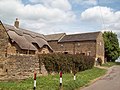
 / 53.29547; -1.40450 (Outbuilding east of Ash Lane Farmhouse)
Thatched Farm in West Handley - geograph.org.uk - 2420895.jpg
Early 19th centuryThe outbuilding is in sandstone with quoins and a roof of slate and stone slate. There are two storeys and five bays, the north three bays higher. On the front are three doorways with massive surrounds and heavy lintels, a doorway converted into a window, three taking-in doors, and slit vents. [14] II
Outbuilding northwest of Ash Lane Farmhouse
53°17′44″N1°24′18″W / 53.29547°N 1.40496°W / 53.29547; -1.40496 (Outbuilding northwest of Ash Lane Farmhouse)
Early 19th centuryThe outbuilding is in sandstone with a roof of corrugated sheet. There is a T-shaped plan, the cross-wing at the north having an overloft, and a gable with weatherboarding and a full width opening below. The main wing has two stable doors, and two feeding troughs with projecting semicircular stone feed shelves under brick arched heads. [15] II
Springwell House
53°17′09″N1°23′52″W / 53.28584°N 1.39776°W / 53.28584; -1.39776 (Springwell House)
Early 19th centuryA brick house with sandstone dressings and a hipped slate roof. There are two storeys and three bays. The central doorway has a rectangular fanlight, and the windows are sashes with stone wedge lintels. [16] II
Railway Viaduct
53°17′13″N1°26′19″W / 53.28707°N 1.43859°W / 53.28707; -1.43859 (Railway Viaduct)
Unstone - Railway Viaduct At Unstone Sidings - 20220903081623.jpg
1870The viaduct was built by the Midland Railway to carry its line over the River Drone. It is in gritstone with brick linings, and consists of seven semicircular stilted arches, rising from tapering rectangular piers. The voussoirs end in a band course, and above is a shallow parapet with railings. [17] II

Related Research Articles

Ballidon is a civil parish in the Derbyshire Dales district of Derbyshire, England. The parish contains 15 listed buildings that are recorded in the National Heritage List for England. All the listed buildings are designated at Grade II, the lowest of the three grades, which is applied to "buildings of national importance and special interest". The parish contains the villages of Ballidon and Pikehall, and Ballidon Quarry, and is otherwise entirely rural. Most of the listed buildings are farmhouses and farm buildings, two of which has been converted for other uses by the quarry. The other listed buildings are a church, a milestone, a lime kiln, and an embankment and bridge, originally carrying a railway, and later part of the High Peak Trail.

Barlow is a civil parish in the North East Derbyshire district of Derbyshire, England. The parish contains 18 listed buildings that are recorded in the National Heritage List for England. Of these, three are listed at Grade II*, the middle of the three grades, and the others are at Grade II, the lowest grade. The parish contains the village of Barlow and the surrounding countryside, mainly to the west of the village. It is almost entirely rural, and the listed buildings are mainly houses and associated structures, farmhouses and farm buildings. The other listed buildings are a church, its former rectory, a bridge, a former school, a pinfold, and a village pump.

Charlesworth is a civil parish in the High Peak district of Derbyshire, England. The parish contains 15 listed buildings that are recorded in the National Heritage List for England. All the listed buildings are designated at Grade II, the lowest of the three grades, which is applied to "buildings of national importance and special interest". The parish contains the village of Charlesworth and the surrounding countryside. Most of the listed buildings are houses and cottages, farmhouses and farm buildings. The other listed buildings are a bridge, a church, a chapel and its associated walls, and a war memorial.

Crich is a civil parish in the Amber Valley district of Derbyshire, England. The parish contains 52 listed buildings that are recorded in the National Heritage List for England. Of these, one is listed at Grade I, the highest of the three grades, one is at Grade II*, the middle grade, and the others are at Grade II, the lowest grade. The parish contains the villages of Crich, Fritchley, Whatstandwell, and Wheatcroft, and the surrounding countryside. Most of the listed buildings are houses, cottages and associated structures, farmhouses and farm buildings. In the parish is the National Tramway Museum, and a number of structures that have been moved from other sites to the museum are listed. The other listed buildings include churches and chapels, a bridge over the Cromford Canal and a road bridge over the River Derwent, public houses, buildings associated with tramways, a milepost, a village cross, a memorial tower, and a village telephone kiosk.

Dale Abbey is a civil parish in the Erewash district of Derbyshire, England. The parish contains 20 listed buildings that are recorded in the National Heritage List for England. Of these, three are listed at Grade I, the highest of the three grades, one is at Grade II*, the middle grade, and the others are at Grade II, the lowest grade. The parish contains the village of Dale Abbey and the surrounding area. The village gets its name from the abbey of the same name, which is in ruins. The abbey ruins are listed, together with buildings in the village, including houses, farmhouses and farm buildings, and a church with an attached house. To the north of the village is a post mill, which is listed together with two associated buildings. To the west of the village is Locko Park, a country house, which is listed together with associated structures and items in its grounds.

Eckington is a civil parish in the North East Derbyshire district of Derbyshire, England. The parish contains 81 listed buildings that are recorded in the National Heritage List for England. Of these, two are listed at Grade I, the highest of the three grades, two are at Grade II*, the middle grade, and the others are at Grade II, the lowest grade. The parish contains the town of Eckington, the villages of Renishaw, Ridgeway, and Spinkhill, the hamlet of Birley Hay, and the surrounding countryside. The major building in the parish is the country house, Renishaw Hall, which is listed, together with associated structures and items in its grounds. Most of the other listed buildings are houses, cottages and associated structures, farmhouses and farm buildings. The rest of the listed buildings include churches, chapels and associated items, a former Sunday school, a former toll house, a public house, and two bridges.

Hathersage is a civil parish in the Derbyshire Dales district of Derbyshire, England. The parish contains 54 listed buildings that are recorded in the National Heritage List for England. Of these, one is listed at Grade I, the highest of the three grades, three are at Grade II*, the middle grade, and the others are at Grade II, the lowest grade. The parish, which is almost entirely rural, contains the village of Hathersage and the surrounding countryside. Most of the listed buildings are farmhouses and farm buildings, houses, cottages, and associated structures. The other listed buildings include two churches, a cross shaft in a churchyard, a presbytery and a vicarage, two bridges, former mills, a milepost, a former toll house, a railway viaduct, and a lamp column.

Holmesfield is a civil parish in the North East Derbyshire district of Derbyshire, England. The parish contains 41 listed buildings that are recorded in the National Heritage List for England. Of these, five are listed at Grade II*, the middle of the three grades, and the others are at Grade II, the lowest grade. The parish contains the village of Holmesfield, the hamlet of Cartledge, and the surrounding countryside and moorland. Most of the listed buildings are houses, cottages and associated structures, farmhouses, and farm buildings. The other listed buildings include two medieval crosses, a cross dated 1619, a church, public houses, a former toll house, a milepost, and two milestones.

Holymoorside and Walton is a civil parish in the North East Derbyshire district of Derbyshire, England. The parish contains 18 listed buildings that are recorded in the National Heritage List for England. All the listed buildings are designated at Grade II, the lowest of the three grades, which is applied to "buildings of national importance and special interest". The parish contains the villages of Holymoorside and Walton, and the surrounding countryside. Most of the listed buildings are houses and associated structures, farmhouses and farm buildings, and the others are a milepost and a war memorial.

Ingleby is a civil parish in the South Derbyshire district of Derbyshire, England. The parish contains five listed buildings that are recorded in the National Heritage List for England. Of these, one is listed at Grade II*, the middle of the three grades, and the others are at Grade II, the lowest grade. The parish contains the village of Ingleby and the surrounding area, and the listed buildings consist of houses, cottages, farmhouses, and associated structures.

Kirk Ireton is a civil parish in the Derbyshire Dales district of Derbyshire, England. The parish contains 27 listed buildings that are recorded in the National Heritage List for England. Of these, one is listed at Grade I, the highest of the three grades, one is at Grade II*, the middle grade, and the others are at Grade II, the lowest grade. The parish contains the village of Kirk Ireton and the surrounding countryside. Most of the listed buildings are houses, cottages and associated structures, farmhouses and farm buildings, and the others are churches and associated structures, and a public house.

Monyash is a civil parish in the Derbyshire Dales district of Derbyshire, England. The parish contains 17 listed buildings that are recorded in the National Heritage List for England. Of these, one is listed at Grade II*, the middle of the three grades, and the others are at Grade II, the lowest grade. The parish contains the village of Monyash and the surrounding countryside. Most of the listed buildings are houses, cottages and associated structures, farmhouses and farm buildings. The other listed buildings include a church, a former chapel, a village cross, a public house, and a telephone kiosk.

Offcote and Underwood is a civil parish in the Derbyshire Dales district of Derbyshire, England. The parish contains twelve listed buildings that are recorded in the National Heritage List for England. All the listed buildings are designated at Grade II, the lowest of the three grades, which is applied to "buildings of national importance and special interest". The parish is almost completely rural and contains no significant settlements. Apart from a milepost, all the listed buildings are houses, farmhouses and associated structures.

Offerton is a civil parish in the Derbyshire Dales district of Derbyshire, England. The parish contains six listed buildings that are recorded in the National Heritage List for England. Of these, one is listed at Grade II*, the middle of the three grades, and the others are at Grade II, the lowest grade. The parish is almost entirely rural, and the listed buildings consist of houses, farmhouses and farm buildings.

Overseal is a civil parish in the South Derbyshire district of Derbyshire, England. The parish contains eight listed buildings that are recorded in the National Heritage List for England. Of these, one is listed at Grade II*, the middle of the three grades, and the others are at Grade II, the lowest grade. The parish contains the village of Overseal and the surrounding area. All the listed buildings are in the village, and consist of houses and associated structures, farmhouses and farmbuildings, a school and a church.

Twyford and Stenson is a civil parish in the South Derbyshire district of Derbyshire, England. The parish contains twelve listed buildings that are recorded in the National Heritage List for England. Of these, one is listed at Grade I, the highest of the three grades, one is at Grade II*, the middle grade, and the others are at Grade II, the lowest grade. The parish contains the villages of Twyford and Stenson and the surrounding countryside. The Trent and Mersey Canal runs through the north of the parish, and the listed buildings associated with it are bridges, a lock and a cottage. The other listed buildings are a church, houses, cottages and associated structures, and farmhouses and farm buildings.

Wessington is a civil parish in the North East Derbyshire district of Derbyshire, England, UK. The parish contains twelve listed buildings that are recorded in the National Heritage List for England. All the listed buildings are designated at Grade II, the lowest of the three grades, which is applied to "buildings of national importance and special interest". The parish contains the village of Wessington and the surrounding countryside. Apart from a railway bridge and a church, all the listed buildings are farmhouses and farm buildings.

Wheston is a civil parish in the Derbyshire Dales district of Derbyshire, England. The parish contains seven listed buildings that are recorded in the National Heritage List for England. Of these, one is listed at Grade II*, the middle of the three grades, and the others are at Grade II, the lowest grade. The parish contains the village of Wheston and the surrounding area. All the listed buildings are in the village, and consist of farmhouses, farm buildings and the village cross.

Wingerworth is a civil parish in the North East Derbyshire district of Derbyshire, England. The parish contains 20 listed buildings that are recorded in the National Heritage List for England. Of these, one is listed at Grade I, the highest of the three grades, one is at Grade II*, the middle grade, and the others are at Grade II, the lowest grade. The parish contains the village of Wingerworth and the surrounding countryside. Most of the listed buildings are houses, cottages and associated structures, farmhouses and farm buildings. The other listed buildings include churches, a public house, a pair of lodges and associated structures, two mileposts, and a bridge with an associated sheepwash.

Wormhill is a civil parish in the High Peak district of Derbyshire, England. The parish contains 26 listed buildings that are recorded in the National Heritage List for England. Of these, three are listed at Grade II*, the middle of the three grades, and the others are at Grade II, the lowest grade. The parish contains the village of Wormhill and the surrounding area. Most of the listed buildings are houses, cottages and associated structures, farmhouses and farm buildings. The other listed buildings include a church and associated structures, a village cross moved into the churchyard, a railway viaduct, and a memorial fountain.

References

Citations

Sources