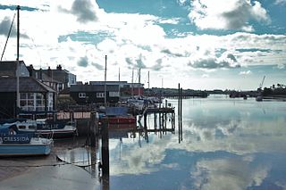
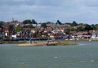
Wivenhoe is a town and civil parish in the Colchester district, in north-eastern Essex, England, approximately 3 miles (5 km) south-east of Colchester. Historically Wivenhoe village, on the banks of the River Colne, and Wivenhoe Cross, on the higher ground to the north, were two separate settlements; however, with considerable development in the 19th century, the two have since merged.

The City of Colchester is a local government district with city status in Essex, England, named after its main settlement, Colchester. It is, with 194,394 people according to Office of National Statistics estimate for mid 2022, the most populous district in Essex and also includes the towns of West Mersea and Wivenhoe and the surrounding rural areas stretching from Dedham Vale on the Suffolk border in the north to Mersea Island in the Colne Estuary in the south.
Maldon District is a local government district in Essex, England. The district is managed by Maldon District Council, which is based in Maldon, the largest town in the district. The district also includes the town of Burnham-on-Crouch and numerous villages, including Heybridge, Wickham Bishops, Southminster, Tolleshunt D'Arcy and Tollesbury. The district covers the Dengie peninsula to the south of Maldon and the Thurstable Hundred area to the north of the Blackwater Estuary, a total area of 358.78 km2.

Nayland is a village and former civil parish, now in the parish of Nayland-with-Wissington, in the Babergh district, in the county of Suffolk, England. It is in the Stour Valley on the Suffolk side of the border between Suffolk and Essex. In 2011 the built-up area had a population of 938.

North Essex was a parliamentary constituency represented in the House of Commons of the Parliament of the United Kingdom between 1997 and 2010. It elected one Member of Parliament (MP) by the first past the post system of election.

Stoke-by-Nayland is a village and civil parish in the Babergh district, in the county of Suffolk, England, close to the border with Essex. The parish includes the village of Withermarsh Green and the hamlets of Thorington Street and Scotland Street. The village has many cottages and timber-framed houses, all surrounding a recreation field. Possibly once the site of a monastery, the population of the civil parish was 703 at the 2001 Census, falling to 682 at the 2011 Census.

Navestock is a civil parish in the Borough of Brentwood in south Essex, in the East of England region of the United Kingdom. It is located approximately 5 km (3.1 mi) northwest of the town of Brentwood and the M25 motorway cuts through the western edge of the parish. It covers an area of in excess of 1800 hectares and had a population of 510 in 2001, increasing to 585 in 2011. The name means ‘the stump on the headland’, which reflects its topography and landscape.

Little Hadham is a village and civil parish in the district of East Hertfordshire, Hertfordshire, England. At the census of 2001 it had a population of 1,081, increasing to 1,153 at the 2011 Census. It is bypassed by the A120 road, which connects it to the nearby town of Bishop's Stortford. The civil parish includes the hamlets of Bury Green, Church End, Cradle End, Green Street and Hadham Ford. Little Hadham, together with the neighbouring village of Much Hadham, are collectively known as The Hadhams.

Great Horkesley is a village in the City of Colchester district of Essex, England, approximately 3 miles north of Colchester.

North Colchester was a Borough Constituency in Essex, represented in the House of Commons of the Parliament of the United Kingdom from 1983 until 1997. It elected one Member of Parliament (MP) by the first past the post system of election.

Earls Colne is a village in Essex, England named after the River Colne, on which it stands, and the Earls of Oxford who held the manor of Earls Colne from before 1086 to 1703.

Wormingford is a village and civil parish in the City of Colchester district of Essex, England.
Little Gaddesden is a village and civil parish in the borough of Dacorum, Hertfordshire 3 miles (4.8 km) north of Berkhamsted, close to the border with Bedfordshire. As well as Little Gaddesden village, the parish contains the settlements of Ashridge, Hudnall, and part of Ringshall. The total population at the 2011 Census was 1,125.

Sotherton is a dispersed village and civil parish in the East Suffolk district, in the English county of Suffolk. It is located approximately 7 miles (11 km) south of Beccles and 3+3⁄4 miles (6.0 km) north-east of Halesworth. The A145 road passes through the east of the parish area. The mid-2005 population estimate for Sotherton parish was 80. Uggeshall is located just to the north-east, Byford to the south and Blythburgh to the south-east. Latitude Festival takes place a couple of miles east.

Shirburn is a village and civil parish about 6 miles (10 km) south of Thame in Oxfordshire. It contains the Grade I listed, 14th-century Shirburn Castle, along with its surrounding, Grade II listed park, and a parish church, the oldest part of which is from the Norman period. The parish has a high altitude by county standards. Its eastern part is in the Chiltern Hills Area of Outstanding Natural Beauty. Shirburn, the largest civil parish in the district, is forested to the south. A motorway cuts across one edge.

Caversfield is a village and civil parish about 1+1⁄2 miles (2.4 km) north of the centre of Bicester. In 1844 Caversfield became part of Oxfordshire, but until then it was always an exclave of Buckinghamshire. The 2011 Census recorded the parish's population as 1,788.

Essex is a ceremonial county in the East of England, and one of the home counties. It is bordered by Cambridgeshire and Suffolk to the north, the North Sea to the east, Kent across the Thames Estuary to the south, Greater London to the south-west, and Hertfordshire to the west. The largest settlement is Southend-on-Sea, and the county town is Chelmsford.

Miles Graye was a dynasty of English bell-founders; who had foundries in Colchester and Saffron Walden in Essex, during the 17th-century. It is believed that the family cast over 415 bells, many of which remain today.

