Little Satilla River (Satilla River)

Last updated
Little Satilla River (Satilla River)
Country United States
Physical characteristics
Main source Georgia

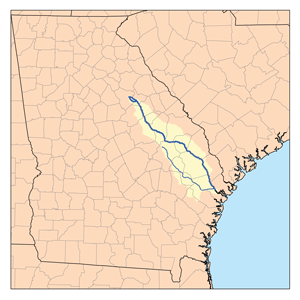
The Little Satilla River is a 28.4-mile-long (45.7 km) [1] freshwater tributary of the Satilla River in the U.S. state of Georgia. It should not be confused with the tidal Little Satilla River that is 20 miles (32 km) to the southeast and is an inlet of the Atlantic Ocean.

Satilla River river in the United States of America

The Satilla River rises in Ben Hill County, Georgia, near the town of Fitzgerald, and flows in a mostly easterly direction to the Atlantic Ocean. Along its approximately 235-mile (378 km) course are the cities of Waycross, Waynesville, and Woodbine. The Satilla drains almost 4,000 square miles (10,000 km2) of land, all of it in the coastal plain of southeastern Georgia. It has white sandbars and is the largest blackwater river situated entirely within Georgia.

U.S. state constituent political entity of the United States

In the United States, a state is a constituent political entity, of which there are currently 50. Bound together in a political union, each state holds governmental jurisdiction over a separate and defined geographic territory and shares its sovereignty with the federal government. Due to this shared sovereignty, Americans are citizens both of the federal republic and of the state in which they reside. State citizenship and residency are flexible, and no government approval is required to move between states, except for persons restricted by certain types of court orders. Four states use the term commonwealth rather than state in their full official names.

Georgia (U.S. state) State of the United States of America

Georgia is a state in the Southeastern United States. It began as a British colony in 1733, the last and southernmost of the original Thirteen Colonies to be established. Named after King George II of Great Britain, the Province of Georgia covered the area from South Carolina south to Spanish Florida and west to French Louisiana at the Mississippi River. Georgia was the fourth state to ratify the United States Constitution, on January 2, 1788. In 1802–1804, western Georgia was split to the Mississippi Territory, which later split to form Alabama with part of former West Florida in 1819. Georgia declared its secession from the Union on January 19, 1861, and was one of the original seven Confederate states. It was the last state to be restored to the Union, on July 15, 1870. Georgia is the 24th largest and the 8th most populous of the 50 United States. From 2007 to 2008, 14 of Georgia's counties ranked among the nation's 100 fastest-growing, second only to Texas. Georgia is known as the Peach State and the Empire State of the South. Atlanta, the state's capital and most populous city, has been named a global city. Atlanta's metropolitan area contains about 55% of the population of the entire state.

The freshwater Little Satilla River forms at the juncture of Big Satilla Creek and Little Satilla Creek, close to the U.S. Route 84 crossing of the two creeks southwest of Screven. The river flows south as the boundary between Wayne and Pierce counties, then turns more southeast as it becomes the boundary between Pierce and Brantley counties. Turning fully to the east, it enters Brantley County, is crossed by U.S. Route 301, and joins the Satilla River 4 miles (6 km) southeast of Hortense.

Big Satilla Creek river in the United States of America

Big Satilla Creek is a 55.8-mile-long (89.8 km) tributary of the Little Satilla River in the U.S. state of Georgia. It is part of the Satilla River watershed of southeastern Georgia.

Little Satilla Creek river in the United States of America

The Little Satilla Creek is a 39.3-mile-long (63.2 km) tributary of the Little Satilla River in the U.S. state of Georgia. It is part of the Satilla River watershed in southeastern Georgia.

U.S. Route 84 highway in the United States

U.S. Route 84 is an east–west U.S. Highway. It started as a short Georgia–Alabama route in the original 1926 scheme, but by 1941 it had been extended all the way to Colorado. The highway's eastern terminus is a short distance east of Midway, Georgia, at an interchange with Interstate 95. The road continues toward the nearby Atlantic Ocean as a county road. Its western terminus is in Pagosa Springs, Colorado, at an intersection with U.S. 160.

Little Satilla River is the boundary between Wayne and Pierce counties. Wayne County border US84EB.jpg
Little Satilla River is the boundary between Wayne and Pierce counties.

See also

Related Research Articles

Pierce County, Georgia County in the United States

Pierce County is a county located in the U.S. state of Georgia. As of the 2010 census, the population was 18,758. The county seat is Blackshear.

Brantley County, Georgia County in the United States

Brantley County is a county located in the U.S. state of Georgia. As of the 2010 census, the population was 18,411. The county seat is Nahunta.

Canoochee River river in the United States of America

The Canoochee River is a 108-mile-long (174 km) river in southeastern Georgia in the United States. It is a tributary of the Ogeechee River, which flows to the Atlantic Ocean. In 1738 the Trustees of the colony mentioned the proposed house and ferry boat over the 'Cooanoochi River'.

The Alabaha River is a 20.6-mile-long (33.2 km) tributary of the Satilla River in the U.S. state of Georgia. It forms in northwestern Pierce County at the junction of Hurricane Creek and Little Hurricane Creek and flows southeast, past the county seat of Blackshear, and joins the Satilla River at the Pierce County/Brantley County boundary.

The Alapahoochee River is a 14.4-mile-long (23.2 km) tributary of the Alapaha River in Georgia and Florida in the United States. Via the Alapaha and Suwannee rivers, its waters flow to the Gulf of Mexico.

Brier Creek is a 123-mile-long (198 km) tributary of the Savannah River in the U.S. state of Georgia. It rises in Warren County east of Camak and flows southeast to the Savannah River in Screven County, 12 miles (19 km) east of Sylvania.

The Buffalo River is a 4.5-mile-long (7.2 km) tidal river northwest of Brunswick, Georgia. It is part of the Brunswick River network of tidal channels along the Atlantic coast of the U.S. state of Georgia.

The Crescent River is a 5.4-mile-long (8.7 km) tidal river in McIntosh County, Georgia, in the United States. It forms in salt marshes east of the community of Bellville Point and flows southeast, ending at a river junction where the Mud River flows northeast into Sapelo Sound and Old Teakettle Creek flows south to Doboy Sound.

The Cumberland River is a 15-mile-long (24 km) tidal channel in the U.S. state of Georgia. It forms the northern half of the waterway that separates Cumberland Island from the Georgia mainland, connecting with Cumberland Sound to the south and St. Andrew Sound and the Satilla River to the north. It forms part of the Atlantic Intracoastal Waterway.

The Jerico River is a 12.8-mile-long (20.6 km) river on the Atlantic coastal plain in the U.S. state of Georgia. It serves as the boundary between Bryan and Liberty counties for its entire length.

The Laurel View River is a 4.6-mile-long (7.4 km) tidal river in the U.S. state of Georgia. It is fed by the Jerico River, which splits into the Laurel View and Belfast rivers, and ends where the Belfast River rejoins it, forming the Medway River, which continues to the Atlantic Ocean. For its entire length, the Laurel View River forms the boundary between Bryan and Liberty counties.

The Little Ogeechee River in Chatham County is one of two rivers by that name in the U.S. state of Georgia. Rising in southern Effingham County, the Little Ogeechee flows to the southeast and enters Chatham County, where it becomes tidal in the vicinity of its crossing by U.S. Route 17. From that point, the river flows through salt marshes and widens considerably, crossing under Georgia State Route 204 west of the Windsor Forest section of Savannah, and ending at Ossabaw Sound just north of the mouth of the Ogeechee River. The entire Little Ogeechee River is 42.8 miles (68.9 km) long.

The Little Satilla River is a 22.6-mile-long (36.4 km) tidal river that forms the boundary between Glynn and Camden counties in the U.S. state of Georgia. It is a separate river from the Little Satilla River, 20 miles (32 km) to the northwest, that is a freshwater tributary of the Satilla River.

Skidaway River river in the United States of America

The Skidaway River is an 8.4-mile-long (13.5 km) tidal river in the U.S. state of Georgia. It is located in Chatham County southeast of Savannah. Its north end is at the Wilmington River, and it flows southwest from there through Skidaway Narrows to end at the Burnside River, which connects via the Vernon and Little Ogeechee rivers with Ossabaw Sound, an arm of the Atlantic Ocean. The Skidaway River flows between Skidaway Island to the east and Dutch Island and Isle of Hope to the west. It is part of the Atlantic Intracoastal Waterway.

The South Newport River is a 42.6-mile-long (68.6 km) river on the Atlantic coastal plain in the U.S. state of Georgia. It rises in Long County 3 miles (5 km) south of Walthourville and flows east-southeast, becoming the boundary between Liberty and McIntosh counties. It flows into Sapelo Sound, an arm of the Atlantic Ocean, south of St. Catherines Island.

Suwannoochee Creek is a 49.0-mile-long (78.9 km) tributary of the Suwannee River in the U.S. state of Georgia. It rises in western Clinch County, Georgia, about 11 miles (18 km) west of Homerville, and flows southeast to join the Suwannee near Fargo. For the lower half of its course it forms the boundary between Clinch and Echols counties.

Willacoochee River river in the United States of America

The Willacoochee River is a 21.5-mile-long (34.6 km) tributary of the Alapaha River in the U.S. state of Georgia. Via the Alapaha and Suwannee rivers, its waters flow to the Gulf of Mexico.

References

  1. U.S. Geological Survey. National Hydrography Dataset high-resolution flowline data. The National Map Archived 2012-04-05 at WebCite , accessed April 21, 2011

Coordinates: 31°17′54″N81°53′49″W / 31.29837°N 81.89706°W / 31.29837; -81.89706

Geographic coordinate system Coordinate system

A geographic coordinate system is a coordinate system that enables every location on Earth to be specified by a set of numbers, letters or symbols. The coordinates are often chosen such that one of the numbers represents a vertical position and two or three of the numbers represent a horizontal position; alternatively, a geographic position may be expressed in a combined three-dimensional Cartesian vector. A common choice of coordinates is latitude, longitude and elevation. To specify a location on a plane requires a map projection.