Liverpool Built-up Area

Last updated

2011 Built-up Area showing subdivisions Liverpool 2011 Built-up Area.svg
2011 Built-up Area showing subdivisions

The Liverpool Built-up Area (previously Liverpool Urban Area in 2001 and prior) is a term used by the Office for National Statistics (ONS) to denote the urban area around Liverpool in England, to the east of the River Mersey. The contiguous built-up area extends beyond the area administered by Liverpool City Council into adjoining local authority areas, particularly parts of Sefton and Knowsley. As defined by ONS, the area extends as far east as St Helens, Haydock, and Ashton-in-Makerfield in Greater Manchester. [1] [2]

Contents

The Liverpool Urban Area is not the same area as Merseyside (or Greater Merseyside), which includes areas of Wirral on the west bank of the Mersey and Southport. [1] The western extent of the Greater Manchester conurbation is narrowly avoided as that extends as far as Golborne and Newton-le-Willows, with small gaps separating those towns from Ashton-In-Makerfield and Haydock.

Settlements

The Liverpool Urban Area defined by ONS covers Liverpool and its contiguous built-up areas, with a population of 864,122 [3] a considerable increase from the 2001 census due to the rapid growth in the population of Liverpool during this period. The population of the area was 816,216 in the 2001 census,. [4] The urban area facing Liverpool on the Wirral Peninsula is a separate division known as the Birkenhead Urban Area. [5]

The ONS definition is based purely on physical criteria with a focus on the presence or absence of significant gaps between built-up areas. It therefore extends as far as Ashton-in-Makerfield, but excludes some areas much closer to Liverpool which are separated from it by open spaces, notably Kirkby with a narrow gap along the M57 motorway, and Maghull.

Subdivisions are not always aligned to present administrative or county borders. For example, Liverpool as designated by the ONS also containing the towns Huyton, Roby, and Halewood which are all within the neighbouring borough of Knowsley. St Helens only covers the settlement, and not the St Helens borough which contains Rainford and Haydock.

According to the ONS, the subcomponents of the Liverpool Urban Area are:

Urban subvisionPopulation (2011) [3] Population (2001) [4] Population (1991) [1] Population (1981) [6]
Liverpool 552,267469,017481,786538,809
St Helens 102,885102,629106,293-
Bootle 51,39459,12365,45470,860
Huyton-with-Roby -54,76656,50062,011
Crosby 50,04451,78952,86954,103
Prescot 37,91139,69537,486-
Ashton-in-Makerfield 28,762---
Litherland 18,50722,24220,90521,989
Haydock 16,52116,95516,705-
Rainford 5,831---
Total864,122816,216837,998747,772

Notes:

Greater Liverpool

Greater Liverpool is an informal term used by the Rent Service as one of its Broad Rental Market Areas (BRMA). [7] This area includes such districts outside the Liverpool City Council boundaries as Crosby, Maghull, Prescot and St Helens.

Merseytravel include a similar Greater Liverpool area for its Public Transport Map and Guide as seen on its Liverpool area map. [8]

Related Research Articles

<span class="mw-page-title-main">Merseyside</span> County of England

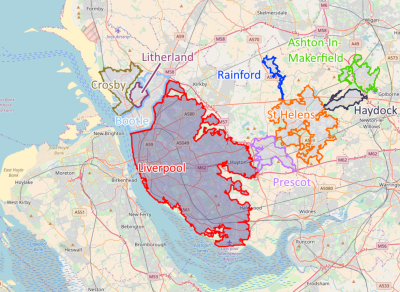
Merseyside is a metropolitan and ceremonial county in North West England. It borders Lancashire to the north, Greater Manchester to the east, Cheshire to the south, the Welsh county of Flintshire across the Dee Estuary to the southwest, and the Irish Sea to the west. The largest settlement is Liverpool.

<span class="mw-page-title-main">Metropolitan Borough of Knowsley</span> Metropolitan borough in England

<span class="mw-page-title-main">Huyton</span> Town in England

Huyton is a town in the Metropolitan Borough of Knowsley, Merseyside, England. Part of the Liverpool Urban Area, it borders the Liverpool suburbs of Dovecot, Knotty Ash and Belle Vale, and the neighbouring village of Roby, with which it formed Huyton with Roby Urban District between 1894 and 1974.

<span class="mw-page-title-main">Ashton-in-Makerfield</span> Town in North West England

Ashton-in-Makerfield is a market town in the Metropolitan Borough of Wigan, Greater Manchester, England, 4 miles (6.4 km) south of Wigan. In 2011, it had a population of 28,762.

<span class="mw-page-title-main">Metropolitan Borough of St Helens</span> Metropolitan borough in England

<span class="mw-page-title-main">West Derby Hundred</span>

The West Derby Hundred is one of the six subdivisions of the historic county of Lancashire, in northern England. Its name alludes to its judicial centre being the township of West Derby.

<span class="mw-page-title-main">Haydock</span> Village in England

Haydock is a village within the Metropolitan Borough of St Helens, in Merseyside, England. At the 2011 Census, it had a population of 11,416 Haydock's historic area covers the Haydock electoral ward and a section of the Blackbrook ward.

<span class="mw-page-title-main">Roby, Merseyside</span> Village in England

Roby is a village in the Metropolitan Borough of Knowsley, Merseyside, England. It was previously administratively linked with its neighbour Huyton by the Huyton-with-Roby civil parish and Huyton with Roby Urban District. Like Huyton, Roby is effectively a dormitory village or suburb of the neighbouring City of Liverpool. At the 2001 Census, the population of Roby was 9,353,. reducing to 7,254 at the 2011 Census. Roby is the location of the sixth form centre of Knowsley Community College.

Merseytravel is the passenger transport executive, responsible for the coordination of public transport in the Liverpool City Region in North West England. Merseytravel was established on 1 December 1969 as the Merseyside Passenger Transport Executive. From 1 April 2014, with the creation of the Liverpool City Region, Merseytravel expanded its area of operation from the metropolitan county of Merseyside to also include the Borough of Halton.

<span class="mw-page-title-main">St Helens, Merseyside</span> Town in Merseyside, England

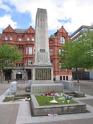
St Helens is a large town in Merseyside, England. It is the administrative centre of the wider Metropolitan Borough of St Helens which covers a larger area around the town.

<span class="mw-page-title-main">River Alt</span> River in Merseyside, England

The River Alt is an urban river that flows across Merseyside in England. The river has suffered from heavy pollution from industry and sewage upstream and run-off from farmland in its lower reaches. It empties into the River Mersey, near to where the Mersey itself flows into the Irish Sea. The river has benefited from clean-up schemes and a de-culverting process to improve its water quality and provide a better environment for wildlife.

<span class="mw-page-title-main">Civil parishes in Merseyside</span>

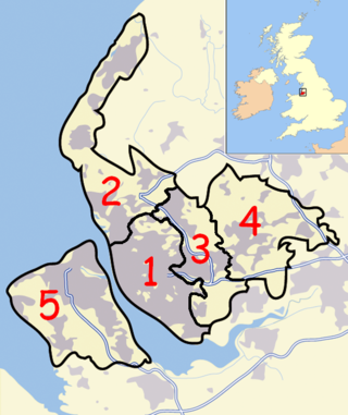
A civil parish is a country subdivision, forming the lowest unit of local government in England. There are 22 civil parishes in the ceremonial county of Merseyside, most of the county being unparished; Liverpool and Wirral are completely unparished. At the 2001 census, there were 177,663 people living in the parishes, accounting for 13.0 per cent of the county's population.

<span class="mw-page-title-main">Liverpool City Region</span> Mayoral combined authority area in Northern England

Liverpool City Region is a mayoral combined authority and local enterprise partnership area in North West England.

<span class="mw-page-title-main">Greater Manchester Built-up Area</span> Conurbation in England

The Greater Manchester Built-up Area is an area of land defined by the Office for National Statistics (ONS), consisting of the large conurbation that encompasses the urban element of the city of Manchester and the metropolitan area that forms much of Greater Manchester in North West England. According to the United Kingdom Census 2011, the Greater Manchester Built-up Area has a population of 2,553,379 making it the second most populous conurbation in the United Kingdom after the Greater London Built-up Area. This was an increase of 14% from the population recorded at the United Kingdom Census 2001 of 2,240,230, when it was known as the Greater Manchester Urban Area.

<span class="mw-page-title-main">History of St Helens, Merseyside</span>

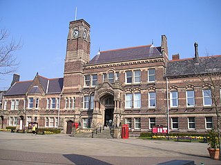
St Helens is a large town and the administrative seat of the Metropolitan Borough of St Helens in Merseyside, England. The town was incorporated as a municipal borough in 1868, responsible for the administration of the four townships and manors of Eccleston, Parr, Sutton and Windle. In 1887 this role was expanded to a county borough, which was superseded in 1974 by the larger metropolitan borough.

References

  1. 1 2 3 "Liverpool Urban Area". Office for National Statistics. Retrieved 30 June 2008.
  2. "2011 Liverpool Built-up Area Area". Office for National Statistics. Retrieved 25 October 2017.
  3. 1 2 "2011 Census - Built-up areas". ONS . Retrieved 29 June 2013.
  4. 1 2 "Key Statistics for urban areas in the North - Contents, Introduction, Tables KS01 - KS08" (PDF). Office for National Statistics. Archived from the original (PDF) on 27 March 2009. Retrieved 30 June 2008.
  5. "Birkenhead Urban Area". Office for National Statistics. Retrieved 30 June 2008.
  6. Census 1981 : key statistics for urban areas : the North, cities and towns. Great Britain. Office of Population Censuses and Surveys. London: H.M.S.O. 1984. ISBN   0116910615. OCLC   10979725.{{cite book}}: CS1 maint: others (link)
  7. Broad Rental Market Areas [ permanent dead link ] (select 'Liverpool' as the Local Authority and hit LA Search - then hit the 'Map' button at the bottom to give map)
  8. Liverpool Area Public Transport Map and Guide

53°24′32″N2°56′02″W / 53.409°N 2.934°W / 53.409; -2.934