
Malawi is a landlocked country in southeast Africa. It is wholly within the tropics; from about 9°30S at its northernmost point to about 17°S at the southernmost tip. The country occupies a thin strip of land between Zambia and Mozambique, extending southwards into Mozambique along the valley of the Shire River. In the north and north east it also shares a border with Tanzania. Malawi is connected by rail to the Mozambican ports of Nacala and Beira. It lies between latitudes 9° and 18°S, and longitudes 32° and 36°E.

Lilongwe is the capital and most populated city of the African country of Malawi. It has a population of 989,318 as of the 2018 Census, up from a population of 674,448 in 2008. In 2020 that figure was 1,122,000. The city is located in the central region of Malawi, in the district of the same name, near the borders with Mozambique and Zambia, and it is an important economic and transportation hub for central Malawi. It is named after the Lilongwe River.
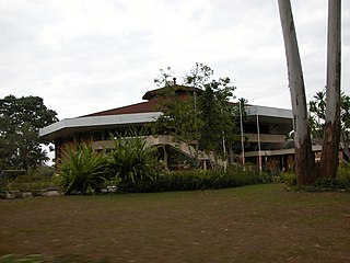
Zomba is a city in southern Malawi, in the Shire Highlands. It is the former capital city of Malawi.

Mangochi is a township in the Southern Region of Malawi. Located near the southern end of Lake Malawi, in colonial times it used to be called Fort Johnston. As of 2018 it has a population of 53,498.

The Southern Region of Malawi is an area of Malawi. It covers an area of 31,753 km². Its capital city is Blantyre. In 2018, its population was 7,750,629.

The Shire Highlands are a plateau in southern Malawi, located east of the Shire River. It is a major agricultural area and the most densely populated part of the country.

The Zomba Plateau, also called the Zomba Massif, is a mountain of the Shire Highlands in southern Malawi. Its total area is about 130 square kilometres (50 sq mi), with a highest point of 2,087 metres (6,847 ft).
The Mangochi District is a hub of commerce. It is a transit point, with roads leading to all areas of Malawi and Mozambique to the east. In fact, the border is not far once you cross the Shire River. To the north, the road bifurcates into the Salima or Monkey Bay roads. To the west, is the hilly region of Dedza. Traveling south, the road climbs up the Machinga escarpment to Zomba, the former colonial capital of Nyasaland, and from there to Malawi's commercial hub of Blantyre. It is fiercely hot in summer and ambient in winter. It is on the flood-plain for Lake Malawi. The lake is the third largest and most southerly in the Rift Valley lake system, and is unofficially known as the Lake of Stars. The lake was named by David Livingston as he discovered it on September 18, 1859, for the effect of the reflection of the sun on the water's surface. It is also known as the Calendar Lake as it is approx 365 miles (587 km) long and 52 wide.

Zomba District is one of twelve districts in the Southern Region of Malawi, surrounded by the districts of Chiradzulu, Blantyre, Mulanje, Phalombe, Machinga, Balaka and the Republic of Mozambique to the east. The total land area is 2,363 km2, representing three percent of the total land area of Malawi. The capital is Zomba.
Liwonde National Park, also known as Liwonde Wildlife Reserve, is a national park in southern Malawi, near the Mozambique border. The park was established in 1973, and has been managed by the nonprofit conservation organization African Parks since August 2015. African Parks built an electric fence around the perimeter of the park to help mitigate human-wildlife conflict. In early 2018, the adjacent Mangochi Forest Reserve was also brought under African Parks' management, almost doubling the size of the protected area.
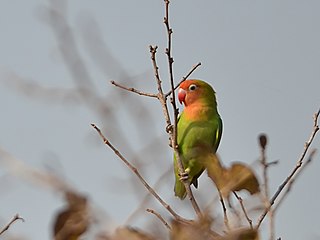
Lilian's lovebird, also known as the Nyasa lovebird, is a small African parrot species of the lovebird genus. It is mainly green and has orange on its upper chest and head. It is 13 cm (5 inches) long and is the smallest parrot on mainland Africa. In captivity, it is uncommon and difficult to breed.
Nkaya, also known as Nacaia, is a town in Malawi, located in the district of Balaka and in the Southern Region of the country.
Mwanza is a town in Malawi on the border with Mozambique. It is the administrative headquarters for Mwanza District.

The history of rail transport in Malawi began shortly after the turn of the twentieth century.

Malosa is a small trading centre located in the Zomba District of Malawi. The Malosa mountain range and plateau neighbours the more famous Zomba Plateau and is separated by the Domasi Valley. Malosa is on the M3, 27 km from the city of Zomba. The earth road from the trading post leads from the edge of the main road right up to the base of the Malosa mountain range.

Nacala railway, also known as Northern Corridor railway and Nacala Corridor railway, is a railway line that operates in northern Mozambique on a 912 kilometres (567 mi) line that runs west from the port city of Nacala, crossing the central region of Malawi, connecting with the coal belt of Moatize, in northwest Mozambique. It is connected to the Dona Ana-Moatize railway branch and the Sena railway (Chipata-Lilongwe-Blantyre-Nhamayabue-Dondo). It also has a 262 kilometres (163 mi) branch line from Cuamba to Lichinga.

Sena railway, also called Shire Highlands railway, Dondo-Malawi railway and North-South Malawi railway, is a railway that connects Dondo, Mozambique, to Chipata, in Zambia. It is c. 1000 km long, in a 1067 mm gauge.
The Lirangwe–Chingale–Machinga Road is a road in the Southern Region of Malawi, connecting the towns of Lirangwe in Blantyre District to the towns of Chingale in Zomba District and the town of Machinga in Machinga District.
Nayuchi is a town located in Machinga District in Malawi. Serving as a border post for road and rail control between Malawi and Mozambique.


