Robert Fulton was an American engineer and inventor who is widely credited with developing the world's first commercially successful steamboat, the North River Steamboat. In 1807, that steamboat traveled on the Hudson River with passengers from New York City to Albany and back again, a round trip of 300 nautical miles, in 62 hours. The success of his steamboat changed river traffic and trade on major American rivers.

Marshall County is a county located in far western portion of the U.S. state of Kentucky. As of the 2020 census, the population was 31,659. Its county seat is Benton.

Livingston County is a county located in the U.S. state of Kentucky. As of the 2020 census, the population was 8,888. Its county seat is Smithland and its largest city is Salem, but its largest community is the census-designated place of Ledbetter. The county was established in 1798 from land taken from Christian County and is named for Robert R. Livingston, a member of the Committee of Five that drafted the U.S. Declaration of Independence. The county was strongly pro-Confederate during the American Civil War and many men volunteered for the Confederate Army. Livingston County is part of the Paducah, KY-IL Micropolitan Statistical Area. It is a prohibition or dry county with the exception of Grand Rivers which voted to allow alcohol sales in 2016.

Grand Rivers is a home rule-class city in Livingston County, Kentucky, in the United States. The population was 382 at the 2010 census, up from 343 in 2000. It is part of the Paducah micropolitan area.

Salem is a home rule-class city in Livingston County, Kentucky, in the United States. Salem is part of the Paducah micropolitan area. The population was 752 during the 2010 census, down from 769 in 2000. It the largest city in Livingston County, although the census-designated place of Ledbetter has more than twice the population of Salem.

Livingston is a home rule-class city in Rockcastle County, Kentucky, in the United States. The population was 226 during the 2010 U.S. census. It is part of the Richmond-Berea micropolitan area.

Sturgis is a home rule-class city in Union County, Kentucky, United States. The population was 1,898 at the 2010 census. Located in northwest Kentucky, the city was founded in 1890 and named for Samuel Sturgis, who owned the land now occupied by the city.

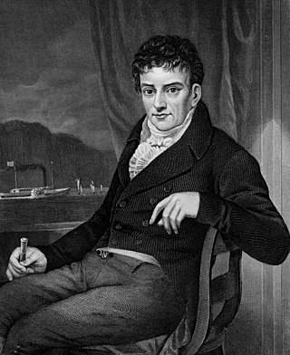
Robert Robert Livingston was an American lawyer, politician, and diplomat from New York, as well as a Founding Father of the United States. He was known as "The Chancellor" after the high New York state legal office he held for 25 years. He was a member of the Committee of Five that drafted the Declaration of Independence, along with Thomas Jefferson, Benjamin Franklin, John Adams, and Roger Sherman. Livingston administered the oath of office to George Washington when he assumed the presidency April 30, 1789. Livingston was also elected as a member of the American Philosophical Society in 1801.

Rush is an unincorporated community in Boyd and Carter counties in the U.S. state of Kentucky. It is part of the Huntington–Ashland metropolitan area. The reason this community was given the name Rush is obscure. It is located along US 60 and near I-64.

Kentucky Route 70 (KY 70) is a long east-east state highway that originates at a junction with U.S. Route 60 (US 60) in Smithland in Livingston County, just east of the Ohio River. The route continues through the counties of Crittenden, Caldwell, Hopkins, Muhlenberg, Butler, Edmonson, Barren, Barren, Metcalfe, Green, Taylor, Casey, Pulaski, Lincoln and back into Pulaski again to terminate at a junction with US 150 near Maretburg in Rockcastle.
Burna is an unincorporated community and census-designated place (CDP) in central Livingston County, Kentucky, United States. As of the 2010 census the population was 257. It is home to the North Livingston Elementary School and Livingston County Middle School.

The Roeliff Jansen Kill is a major tributary to the Hudson River. Roeliff Jansen Kill was the traditional boundary between the Native American Mahican and Wappinger tribes.
Hellier is an unincorporated community and coal town in Pike County, Kentucky, United States.
Hatfield is an unincorporated community in Pike County, Kentucky, United States.
Robinson Creek is an unincorporated community located in Pike County, Kentucky, United States.
Iuka is an unincorporated community in southeast Livingston County, Kentucky, United States. The community is at the intersection of Kentucky routes 917 and 93. The Cumberland River flows past the east side of the community.
Hampton is an unincorporated community in northern Livingston County, Kentucky, United States. The community is on Kentucky Route 135 approximately 13 miles south of Carrsville and the Ohio River.

The 1928 United States presidential election in Kentucky took place on November 6, 1928 as part of the 1928 United States presidential election. Voters chose 13 representatives, or electors to the Electoral College, who voted for president and vice president.


