Weyburn is the eleventh-largest city in Saskatchewan, Canada. The city has a population of 10,870. It is on the Souris River 110 km (68 mi) southeast of the provincial capital of Regina and is 70 km (43 mi) north from the North Dakota border in the United States. The name is reputedly a corruption of the Scottish "wee burn," referring to a small creek. The city is surrounded by the Rural Municipality of Weyburn No. 67.

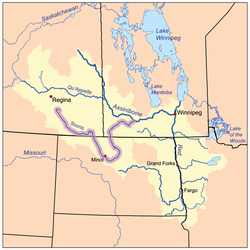
The Souris River or Mouse River is a river in central North America. Approximately 435 miles (700 km) in length, it drains about 23,600 square miles (61,100 km2) in Canada and the United States.

Radville is a small town in Canadian province of Saskatchewan. The town is in the RM of Laurier No. 38. It was incorporated in 1911 after being settled in 1895. Highway 28 and Highway 377 pass through the town. Nearby communities include the village of Ceylon, 23 km to the west, and the city of Weyburn, 51 km to the north-east. Major nearby urban centres include Regina, which is 148 km to the north, and Moose Jaw, which is 143 km north-west.

The Grant Devine Dam, formerly Alameda Dam, is an embankment dam located near Alameda, and Oxbow, Saskatchewan, Canada. It was constructed in 1994 to control flows on the Moose Mountain Creek, and Souris River. It provides flood protection and irrigation for this area of Saskatchewan, along with protection for Minot, North Dakota. The Grant Devine Reservoir provides opportunities for recreational use such as boating and fishing. At the full supply level of 562 metres (1,844 ft), the reservoir holds 105,000,000 cubic metres (3.7×10⁹ cu ft) of water. The project is owned and operated by the Saskatchewan Water Security Agency (formerly Saskatchewan Watershed Authority).

The Antler River is located in the Prairie Pothole Region of North America's Great Plains in south-eastern Saskatchewan and south-western Manitoba in Canada in an area known as Palliser's Triangle. Its source is in Saskatchewan's Moose Mountain Upland and it is a major tributary of the Souris River. As a result, its flood levels are monitored by the United States Geological Survey.
Gainsborough Creek is a tributary of the Souris River in south-eastern Saskatchewan and south-western Manitoba. It is in a region called the Prairie Pothole Region of North America, which extends throughout three Canadian provinces and five U.S. states. It is also within Palliser's Triangle and the Great Plains ecoregion.

Highway 18 is a highway in the Canadian province of Saskatchewan. It runs from Highway 13 near Robsart, approximately 65 km (40 mi) east of the Alberta border, to the Manitoba border near Gainsborough, where it becomes Highway 3. It passes through three major communities, all in the eastern quarter of Saskatchewan – Estevan, Oxbow, and Carnduff; it also passes north of the west and east blocks of Grasslands National Park. Highway 18 is about 712 km (442 mi) long, which is the longest east-west highway and second longest highway in Saskatchewan.

Highway 35 is a paved undivided provincial highway in the Canadian province of Saskatchewan. It runs from the US Border near Port of Oungre to a dead end near the north shore of Tobin Lake. Saskatchewan Highway 35 (SK Hwy 35) is about 569 kilometres (354 mi) long. The CanAm Highway comprises Saskatchewan Highways 35, SK Hwy 39, SK Hwy 6, SK Hwy 3, SK Hwy 2 and U.S. Route 85. 74.6 kilometres (46.4 mi) of SK Hwy 35 contribute to the CanAm Highway between Port of Oungre on the Canada – United States border and Weyburn. Mudslides, and spring flooding were huge road building and maintenance problems around Nipawin as well as along the southern portion of the route named the Greater Yellow Grass Marsh. Over 20 early dams were built until the problem was addressed with the Rafferty-Alameda Project on the Souris River and the construction of the Qu'Appelle River Dam which have helped to eliminate washed out roads and flooded communities. The highway through the homesteading community followed the Dominion Land Survey on the square until reaching the Saskatchewan River at Nipawin. The completion of the combined railway and traffic bridge over the Saskatchewan River at Nipawin in the late 1920s retired the ferry and basket crossing for traffic north of Nipawin. The E.B. Campbell Dam built in 1963 northeast of Nipawin created Tobin Lake, and Codette Lake was formed with the construction of the Francois-Finlay Hydroelectric dam at Nipawin. The railway/traffic bridge that formed part of Highway 35 was the only crossing utilized at Nipawin until a new traffic bridge was constructed in 1974. The new bridge then became part of the combined Highway 35 and 55 until the highway parts just east of White Fox. Highway 35 then continued north along the west side of Tobin Lake. The railway/traffic bridge continues to be utilized for one lane vehicle traffic controlled by traffic lights, and continues as the "old highway 35" on the west side of the river until it joins with the current Highway 35/55.

Highway 39 is a provincial, paved, undivided highway located in the southern portion of the Canadian province of Saskatchewan connecting North Portal and Moose Jaw in the north. This is a primary Saskatchewan highway maintained by the provincial and national governments and providing a major trucking and tourism route between the United States via Portal, Burke County, North Dakota, and North Portal, Saskatchewan. On July 3, 2000, Highways and Transportation Minister Maynard Sonntag officiated at the ribbon cutting ceremony opening the new duty-free shop and the twinned highway at Saskatchewan's busiest border crossing. Highway 39 is one of Canada's busiest highways, facilitating transport for $6 billion in trade goods via approximately 100,000 trucks over the year. The entire length of highway 39 is paved. The CanAm Highway comprises Saskatchewan Highways Hwy 35, Hwy 39, Hwy 6, Hwy 3, as well as Hwy 2. 44.3 miles (71.3 km) of Saskatchewan Highway 39 contribute to the CanAm Highway between Weyburn and Corinne. Highway 39 is divided or twinned in two areas at North Portal as well as north of Weyburn for 1.7 kilometres (1.1 mi). The junction of Hwy 39 with the Trans–Canada divided four-lane highway is done via a "Parclo" or partial cloverleaf interchange.

Boundary Dam Reservoir is a man-made lake in the south-east corner of the province of Saskatchewan, Canada. It is in census division 1, in the RM of Estevan. The closest city is Estevan, which is 5.5 kilometres downstream. There are no towns or villages along the lake's shore but there are two subdivisions and a regional park. The subdivisions, which are in the RM of Estevan, are called Sunset Bay and Lakewood. The primary inflow and outflow for the reservoir is Long Creek. There is a 10-kilometre long diversion channel that goes to McDonald Lake that can take excess water in either direction.

The 2011 Souris/Mouse River flood in Canada and the United States occurred in June and was greater than a hundred-year flooding event for the river. The US Army Corps of Engineers estimated the flood to have a recurrence interval of two to five centuries.

McDonald Lake, also known as Rafferty Reservoir, is a reservoir in south-east Saskatchewan, Canada. It was created when the Rafferty Dam was built on the Souris River in 1994. Before the dam was built that flooded the Souris Valley, McDonald Lake was a small lake and marsh on the valley floor adjacent to the Souris River.
Moose Mountain Upland, Moose Mountain Uplands, or commonly Moose Mountain, is a hilly plateau located in the south-east corner of the Canadian province of Saskatchewan, that covers an area of about 13,000 km2 (5,000 sq mi). The upland rises about 200 m (660 ft) above the broad, flat prairie which is about 600 m (2,000 ft) above sea level. The highest peak is "Moose Mountain" at 830 m (2,720 ft) above sea level. The area was named Moose Mountain because of the large number of moose that lived in the area. When it was originally used by fur traders, Métis, and the Indigenous peoples, the plateau was called Montagne a la Bosse, which is French for "The Mountain of The Bump or Knob."

Pipestone Creek is a river in the Souris River watershed. Its flow begins in south-eastern Saskatchewan, just south of the town of Grenfell and travels in a south-eastly direction into Manitoba in the Westman Region where it empties into Oak Lake through the Oak Lake Marsh.

Moose Mountain Creek is a river in the province of Saskatchewan, Canada. Its source is the Chapleau Lakes near Montmartre and it is a tributary of the Souris River, which, in turn, is a tributary of the Assiniboine River. The whole system is part of the Red River watershed, which is part of the Hudson Bay drainage basin and in a region called the Prairie Pothole Region of North America, which extends throughout three Canadian provinces and five U.S. states. It is also within Palliser's Triangle and the Great Plains ecoregion.

Moose Mountain Lake is a reservoir in the Canadian Province of Saskatchewan. It is located in the RM of Golden West No. 95 in the Prairies Ecozone of Palliser's Triangle at the western edge of Moose Mountain Upland. Moose Mountain Creek is both the primary inflow and outflow of the lake; it enters at the north end and leaves at the dam in the south end. A secondary inflow that comes from Gooseberry Lake enters on the western side near the south end.

Graham Creek, a tributary of the Souris River, is a river that flows from Saskatchewan near Maryfield into Manitoba where it meets the Souris River on the west side of Melita, Manitoba. The Souris River, in turn, drains into the Assiniboine River, which is part of the Red River drainage basin in a region called the Prairie Pothole Region of North America. That region extends throughout three Canadian provinces and five U.S. states. It is also within Palliser's Triangle and the Great Plains ecoregion.

Brightwater Creek is a river in south central Saskatchewan, Canada. It is a tributary of the South Saskatchewan River in a region called the Prairie Pothole Region of North America, which extends throughout three Canadian provinces and five U.S. states. It is also within Palliser's Triangle and the Great Plains ecoregion.

Moose Jaw River is a river in the Canadian province of Saskatchewan. It is located in the southern part of the province in a region called the Prairie Pothole Region of North America, which extends throughout three Canadian provinces and five U.S. states. It is also within Palliser's Triangle and the Great Plains ecoregion.
Avonlea Creek is a river in the southern part of the Canadian province of Saskatchewan. It is in a region called the Prairie Pothole Region of North America, which extends throughout three Canadian provinces and five U.S. states. It is also within Palliser's Triangle and the Great Plains ecoregion. Avonlea Creek is a main tributary of the Moose Jaw River, which is part of the Upper Qu'Appelle Watershed and the Hudson Bay drainage basin.