Lower Falls (District Electoral Area)

Last updated

Lower Falls
District Electoral Area
Lower Falls Wards.png
Map showing Lower Falls wards within Belfast
Population(2008 Estimate)
District
County
Country Northern Ireland
Sovereign state United Kingdom
UK Parliament
NI Assembly
List of places
UK
Northern Ireland
Antrim

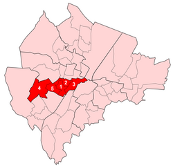
Lower Falls was one of the nine district electoral areas which existed in Belfast, Northern Ireland from 1985 to 2014. Located in the west of the city, the district elected five members to Belfast City Council and contained the wards of Beechmount; Clonard; Falls; Upper Springfield; and Whiterock. Lower Falls formed part of the Belfast West constituencies for the Northern Ireland Assembly and UK Parliament. The district, along with the neighbouring Upper Falls district took its name from the Falls Road, one of the main arterial routes in the west of the city.

Contents

History

Lower Falls was created for the 1985 local elections. The Falls and Clonard wards had previously been in Area F, with the remaining wards part of Area D. It was abolished for the 2014 local elections. The Falls and Clonard wards joined the Court District Electoral Area, while the remaining wards became part of a new Black Mountain District Electoral Area.

Wards

MapWardPopulation
(2011 Census)
CatholicProtestantOtherNo ReligionAreaDensity NI Assembly UK Parliament Ref
1Beechmount5,48590.8%6.1%0.6%2.5%0.84 km26,530/km2 Belfast West Belfast West [1]
2Clonard4,97590.5%6.4%0.6%2.6%0.61 km28,156/km2 Belfast West Belfast West [2]
3Falls5,18487.6%7.5%2.3%2.6%1.2 km24,320/km2 Belfast West Belfast West [3]
4Upper Springfield5,25093.5%4.6%0.3%1.6%2.5 km22,100/km2 Belfast West Belfast West [4]
5Whiterock5,69493.1%4.7%0.3%1.8%0.78 km27,300/km2 Belfast West Belfast West [5]
Lower Falls26,58891.1%5.8%0.3%1.8%5.93 km24,484 /km2 Belfast West Belfast West

Councillors

ElectionCouncillor
(Party)
Councillor
(Party)
Councillor
(Party)
Councillor
(Party)
Councillor
(Party)
2011 Tom Hartley
(Sinn Féin)
Jim McVeigh
(Sinn Féin)
Steven Corr
(Sinn Féin)
Janice Austin
(Sinn Féin)
Colin Keenan
(SDLP)
2005 Marie Moore
(Sinn Féin)
Máire Cush
(Sinn Féin)
Fra McCann
(Sinn Féin)
2001 Margaret Walsh
(SDLP)
1997 Seán McKnight
(Sinn Féin)
1993 Mary Muldoon
(SDLP)
Patsy McGeown
(Sinn Féin)
1989 Elizabeth Fitzsimons
(Sinn Féin)
Seán McKnight
(Sinn Féin)
Joe Hendron
(SDLP)
1985 Seán Keenan
(Sinn Féin)
Will Glendinning
(Alliance)

2011 Election

2005: 5 x Sinn Féin

2011: 4 x Sinn Féin, 1 x SDLP

2005-2011 Change: SDLP gain from Sinn Féin

Lower Falls - 5 seats [6]
PartyCandidateFPv%Count
12345
Sinn Féin Janice Austin*19.66%1,920    
Sinn Féin Steven Corr16.10%1,5721,583.85 1,603.85 1,618 1,677
Sinn Féin Tom Hartley *15.99%1,5611,566.1 1,581.1 1,602.25 1,666.25
Sinn Féin Jim McVeigh15.33%1,4971,499.7 1,531 1,544.15 1,600.45
SDLP Colin Keenan10.24%1,0001,003.15 1,058.15 1,214.15 1,326.15
Sinn Féin Breige Brownlee8.33%8131,070.7 1,109 1,123 1,188.3
éirígí John McCusker6.63%647647.6 723.6 748.6  
Workers' Party John Lowry4.08%398398.45 430.45   
Irish Republican Socialist Jim Gorman2.14%209209.75    
Socialist Party Pat Lawlor1.52%148148.5    
Electorate: 17,238  Valid: 9,765 (56.65%)  Spoilt: 305  Quota: 1,628  Turnout: 10,070 (58.42%)  

    2005 Election

    2001: 4 x Sinn Féin, 1 x SDLP

    2005: 5 x Sinn Féin

    2001-2005 Change: Sinn Féin gain from SDLP

    Lower Falls - 5 seats [7]
    PartyCandidateFPv%Count
    1234
    Sinn Féin Janice Austin19.42%2,071   
    Sinn Féin Fra McCann *19.17%2,045   
    Sinn Féin Tom Hartley *18.39%1,962   
    Sinn Féin Máire Cush*15.33%1,7641,797  
    Sinn Féin Marie Moore*11.67%1,2451,253 1,528.1 1,764.42
    SDLP Margaret Walsh*11.86%1,2651,439 1,449.95 1,476.27
    Workers' Party John Lowry2.94%314   
    Electorate: 16,334  Valid: 10,666 (65.30%)  Spoilt: 392  Quota: 1,778  Turnout: 11,058 (67.70%)  

      2001 Election

      1997: 4 x Sinn Féin, 1 x SDLP

      2001: 4 x Sinn Féin, 1 x SDLP

      1997-2001 Change: No change

      Lower Falls - 5 seats [8]
      PartyCandidateFPv%Count
      12345
      Sinn Féin Fra McCann *18.97%2,399    
      Sinn Féin Tom Hartley *18.59%2,351    
      Sinn Féin Máire Cush17.63%2,230    
      SDLP Margaret Walsh*15.94%2,0162,262   
      Sinn Féin Marie Moore*15.16%1,9171,928 1,955.17 1,977.94 1,996.94
      Sinn Féin Sean McKnight*9.86%1,2471,272 1,521.99 1,735.83 1,761.83
      Workers' Party John Lowry3.86%488    
      Electorate: 18,349  Valid: 12,648 (68.93%)  Spoilt: 581  Quota: 2,109  Turnout: 13,229 (72.10%)  

        1997 Election

        1993: 4 x Sinn Féin, 1 x SDLP

        1997: 4 x Sinn Féin, 1 x SDLP

        1993-1997 Change: No change

        Lower Falls - 5 seats [9]
        PartyCandidateFPv%Count
        1234
        Sinn Féin Fra McCann *19.65%2,420   
        Sinn Féin Sean McKnight18.56%2,286   
        SDLP Margaret Walsh14.32%1,7641,775.4 2,248.7 
        Sinn Féin Tom Hartley *16.42%2,0222,047.05 2,061.05 
        Sinn Féin Marie Moore*14.70%1,8101,822.15 1,829.15 2,033.65
        Sinn Féin Janice Austin10.34%1,2741,581.35 1,606.25 1,625.75
        Workers' Party John Lowry3.80%468468.75   
        SDLP Mary White1.84%227227.9   
        Alliance Keith Jacques0.37%4545.3   
        Electorate: 19,372  Valid: 12,316 (63.58%)  Spoilt: 390  Quota: 2,053  Turnout: 12,706 (65.59%)  

          1993 Election

          1989: 3 x Sinn Féin, 2 x SDLP

          1993: 4 x Sinn Féin, 1 x SDLP

          1989-1993 Change: Sinn Féin gain from SDLP

          Lower Falls - 5 seats [10]
          PartyCandidateFPv%Count
          123456
          Sinn Féin Tom Hartley 19.79%2,573     
          Sinn Féin Fra McCann *18.40%2,393     
          Sinn Féin Patrick McGeown18.09%2,352     
          Sinn Féin Marie Moore14.97%1,9462,316.77    
          SDLP Mary Muldoon*13.45%1,7491,760.39 1,832.92 1,929.38 2,030.98 2,325.98
          SDLP Margaret Walsh7.59%987991.93 1,049.44 1,134.77 1,165.97 1,306.48
          Workers' Party John Lowry6.11%794804.37 831.54 874.47 924.07  
          Alliance Patrick Woods0.83%108109.87     
          Democratic Left Mary McMahon0.78%101105.24     
          Electorate: 19,978  Valid: 13,003 (65.09%)  Spoilt: 509  Quota: 2,168  Turnout: 13,512 (67.63%)  

            1989 Election

            1985: 3 x Sinn Féin, 1 x SDLP, 1 x Alliance

            1989: 3 x Sinn Féin, 2 x SDLP

            1985-1989 Change: SDLP gain from Alliance

            Lower Falls - 5 seats [11]
            PartyCandidateFPv%Count
            12345
            SDLP Joe Hendron *23.51%2,748    
            Sinn Féin Fra McCann 19.73%2,307    
            Sinn Féin Elizabeth Fitzsimons*15.10%1,7651,786.7 1,816.25 1,849.69 1,885.5
            Sinn Féin Sean McKnight*12.22%1,4281,461.48 1,466.72 1,750.56 1,774.62
            SDLP Mary Muldoon5.03%5881,196.84 1,257.51 1,261.19 1,738.98
            Sinn Féin Richard May13.91%1,6261,634.68 1,637.68 1,651.92 1,679.45
            Workers' Party Mary McMahon9.35%1,0931,186 1,218.75 1,224.19  
            Alliance Derrick Crothers 1.15%135164.45    
            Electorate: 20,095  Valid: 11,690 (58.17%)  Spoilt: 570  Quota: 1,949  Turnout: 12,260 (61.01%)  

              1985 Election

              1985: 3 x Sinn Féin, 1 x SDLP, 1 x Alliance

              Lower Falls - 5 seats [12]
              PartyCandidateFPv%Count
              1234
              SDLP Joe Hendron *22.06%2,606   
              Sinn Féin Sean McKnight16.41%1,9391,963 1,985.4 
              Alliance Will Glendinning *9.42%1,1131,195 1,549.48 2,015.48
              Sinn Féin Sean Keenan14.83%1,7521,764 1,795.36 1,845.2
              Sinn Féin Elizabeth Fitzsimons13.50%1,5951,609 1,649.6 1,697.4
              Sinn Féin Fra McCann 12.42%1,4671,472 1,499.44 1,552.4
              Workers' Party Mary McMahon9.44%1,1151,168 1,312.2  
              SDLP Sean Mullan1.35%159   
              Communist Party Desmond Murray0.57%67   
              Electorate: 21,058  Valid: 11,813 (56.10%)  Spoilt: 450  Quota: 1,969  Turnout: 12,263 (58.23%)  

                See also

                Related Research Articles

                <span class="mw-page-title-main">Belfast West (UK Parliament constituency)</span> Parliamentary constituency in the United Kingdom, 1885–1918 and since 1922

                Belfast West is a parliamentary constituency (seat) in the House of Commons of the UK Parliament. The current MP is Paul Maskey of Sinn Féin.

                <span class="mw-page-title-main">Balmoral (District Electoral Area)</span>

                Balmoral is the most southern of ten district electoral areas (DEA) in Belfast, Northern Ireland. The district elects five members to Belfast City Council and contains the wards of Belvoir; Finaghy; Malone; Musgrave; Windsor; and Upper Malone. Balmoral, along with neighbouring Botanic, forms the greater part of the Belfast South constituencies for the Northern Ireland Assembly and UK Parliament.

                <span class="mw-page-title-main">Castle (District Electoral Area)</span> District Electoral Area in Belfast, Northern Ireland

                Castle is one of the ten district electoral areas in Belfast, Northern Ireland. Located in the north of the city, the district elects six members to Belfast City Council and contains the wards of Bellevue, Cavehill, Chichester Park, Duncairn, Fortwilliam and Innisfayle. Castle, along with Oldpark district and parts of the Court district and Newtownabbey Borough Council, forms the Belfast North constituency for the Northern Ireland Assembly and UK Parliament. The district is bounded to the east by the Victoria Channel, to the north by Newtownabbey Borough Council and Belfast Lough, to the south by North Street and to the west by the Cavehill Road.

                <span class="mw-page-title-main">Court (District Electoral Area)</span>

                Court is one of the ten district electoral areas (DEA) in Belfast, Northern Ireland. Located in the north and west of the city, the district elects six members to Belfast City Council and contains the wards of Ballygomartin, Clonard, Falls, Forth River, Shankill, and Woodvale. Court is split between the Belfast North and Belfast West constituencies for the Northern Ireland Assembly and UK Parliament.

                <span class="mw-page-title-main">Laganbank (District Electoral Area)</span> Human settlement in Northern Ireland

                Laganbank was one of the nine district electoral areas in Belfast, Northern Ireland which existed from 1985 to 2014. Located in the south of the city, the district elected five members to Belfast City Council and contained the wards of Ballynafeigh, Botanic, Shaftesbury, Stranmillis, and Rosetta. Laganbank, along with neighbouring Balmoral, formed the greater part of the Belfast South constituencies for the Northern Ireland Assembly and UK Parliament.

                <span class="mw-page-title-main">Oldpark (District Electoral Area)</span>

                Oldpark is one of the ten district electoral areas (DEA) in Belfast, Northern Ireland. Located in the north of the city, the district elects six members to Belfast City Council and contains the wards of Ardoyne; Ballysillan; Cliftonville; Legoniel; New Lodge and Water Works. Oldpark forms part of the Belfast North constituency for the Northern Ireland Assembly and UK Parliament.

                <span class="mw-page-title-main">Pottinger (District Electoral Area)</span> Human settlement in Northern Ireland

                Pottinger was one of the nine district electoral areas (DEA) in Belfast, Northern Ireland from 1985 to 2014. Located in the east of the city, the district elected six members to Belfast City Council and contained the wards of Ballymacarrett, Bloomfield, Orangefield, Ravenhill, The Mount, and Woodstock.

                <span class="mw-page-title-main">Upper Falls (District Electoral Area)</span> Human settlement in Northern Ireland

                Upper Falls was one of the nine district electoral areas (DEA) which existed in Belfast, Northern Ireland from 1985 to 2014. Located in the west of the city, the district elected five members to Belfast City Council and contained the wards of Andersonstown; Falls Park; Glen Road; Glencolin; and Ladybrook. Upper Falls formed part of the Belfast West constituencies for the Northern Ireland Assembly and UK Parliament. The district, along with the neighbouring Lower Falls district, took its name from the Falls Road, one of the main arterial routes in the west of the city.

                Area D was one of the eight district electoral areas (DEA) which existed in Belfast, Northern Ireland from 1973 to 1985. Located in the west of the city, the district elected six members to Belfast City Council and contained the wards of Andersonstown; Ladybrook; Milltown; Saint James; Suffolk; and Whiterock. The DEA largely formed part of the Belfast West constituency.

                Castlereagh South is one of the seven district electoral areas (DEA) in Lisburn and Castlereagh, Northern Ireland. The district elects five members to Lisburn and Castlereagh City Council and contains the wards of Beechill, Cairnshill, Carryduff East, Carryduff West, Galwally, Knockbracken and Newtownbreda. Castlereagh South forms part of the Belfast South constituencies for the Northern Ireland Assembly and UK Parliament.

                Dunmurry Cross was one of the district electoral areas in Lisburn, Northern Ireland which existed from 1985 to 2014. It was one of four Lisburn DEAs until 1993, and one of five until 2014. The district elected seven members to Lisburn City Council and formed part of Belfast West constituencies for the Northern Ireland Assembly and UK Parliament and part of the Lagan Valley constituencies for the Northern Ireland Assembly and UK Parliament.

                Antrim Line was one of the district electoral areas in Newtownabbey, Northern Ireland which existed from 1985 to 2014, one of five DEAs until 1993 and one of four DEAs until 2014. The district elected five members to Newtownabbey Borough Council until 1993 and seven members until 2014, and formed part of the South Antrim constituencies for the Northern Ireland Assembly and UK Parliament and part of the Belfast North constituencies for the Northern Ireland Assembly and UK Parliament.

                Benbradagh is one of the seven district electoral areas (DEA) in Causeway Coast and Glens, Northern Ireland. The district elects five members to Causeway Coast and Glens Borough Council and contains the wards of Altahullion, Ballykelly, Dungiven, Feeny and Greysteel. Benbradagh forms part of the East Londonderry constituencies for the Northern Ireland Assembly and UK Parliament.

                Loughside was one of the four district electoral areas in Craigavon, Northern Ireland which existed from 1985 to 2014. The district elected five members to Craigavon Borough Council, and formed part of the Upper Bann constituencies for the Northern Ireland Assembly and UK Parliament.

                Mid Tyrone is one of the seven district electoral areas (DEA) in Fermanagh and Omagh, Northern Ireland. The district elects six members to Fermanagh and Omagh District Council and contains the wards of Beragh, Drumnakilly, Gortin, Owenkillew, Sixmilecross and Termon. Omagh forms part of the West Tyrone constituencies for the Northern Ireland Assembly and UK Parliament.

                Erne North is one of the seven district electoral areas (DEA) in Fermanagh and Omagh, Northern Ireland. The district elects five members to Fermanagh and Omagh District Council and contains the wards of Ballinamallard, Belleek and Boa, Ederney and Kesh, Irvinestown and Tempo. Erne North forms part of the Fermanagh and South Tyrone constituencies for the Northern Ireland Assembly and UK Parliament.

                Mourne was one of the three district electoral areas in Strabane, Northern Ireland which existed from 1985 to 2014. The district elected five members to Strabane District Council until 1993, and six members until 2014, and formed part of the West Tyrone constituencies for the Northern Ireland Assembly and UK Parliament.

                Shantallow was one of the five district electoral areas in Derry, Northern Ireland which existed from 1985 to 2014. The district elected five members to Derry City Council, and formed part of the Foyle constituencies for the Northern Ireland Assembly and UK Parliament.

                Northland was one of the five district electoral areas in Derry, Northern Ireland which existed from 1985 to 2014. The district elected six members to Derry City Council until 1993, and seven members until 2014, and formed part of the Foyle constituencies for the Northern Ireland Assembly and UK Parliament.

                Cityside was one of the five district electoral areas in Derry, Northern Ireland which existed from 1985 to 2014. The district elected six members to Derry City Council until 1993, and five members until 2014, and formed part of the Foyle constituencies for the Northern Ireland Assembly and UK Parliament.

                References

                1. "Ward Information for Beechmount ward 95GG07". NISRA. Retrieved 22 December 2013.
                2. "Ward Information for Clonard ward 95GG18". NISRA. Retrieved 22 December 2013.
                3. "Ward Information for Falls ward 95GG21". NISRA. Retrieved 22 December 2013.
                4. "Ward Information for Upper Springfield ward 95GG46". NISRA. Retrieved 22 December 2013.
                5. "Ward Information for Whiterock ward 95GG48". NISRA. Retrieved 22 December 2013.
                6. "Lower Falls Result Sheet" (PDF). EONI. Retrieved 8 July 2021.
                7. "Local Government Results 2005". EONI. Retrieved 8 July 2021.
                8. "Local Government Results 2001". EONI. Retrieved 8 July 2021.
                9. "Local Government Results 1997". EONI. Retrieved 8 July 2021.
                10. "Local Government Results 1993". EONI. Retrieved 8 July 2021.
                11. "Local Government Results 1989". EONI. Retrieved 8 July 2021.
                12. "Local Government Results 1985". EONI. Retrieved 8 July 2021.