
The European Environment Agency (EEA) is the agency of the European Union (EU) which provides independent information on the environment.
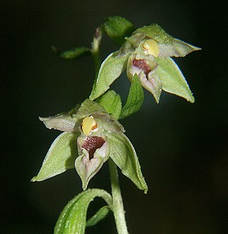
Epipactis leptochila, the narrow-lipped helleborine, is a species of orchid in the genus Epipactis. Found in chalk or limestone-based beech and hornbeam woodland in southern England, the orchids are also found with birch and alder trees in Scotland and the north of England. The narrow-lipped helleborine blooms from early June to mid-August. Epipactis leptochila is also found in parts of northern Europe but it is known for its presence in England. Due to woodland clearing, the orchids are becoming less common.

Monkswood Valley is a 30.7-hectare biological Site of Special Scientific Interest (SSSI) near the village of Cold Ashton, South Gloucestershire, notified in 1990.

Beskydy Protected Landscape Area (PLA) is the largest PLA in the Czech Republic. The area is 1,160 km2 (450 sq mi).

Somiedo Natural Park is a protected area located in the central area of the Cantabrian Mountains in the Principality of Asturias in northern Spain. As well as being designated a natural park, it is protected as a Special Area of Conservation, and as one of a number of Biosphere Reserves in the Cantabrian mountains.(see note)

The Krausnick hills are a small range of hills in Eastern Germany in the federal state of Brandenburg.

Salburua is a wetland habitat on the eastern outskirts of the city of Vitoria-Gasteiz in the Basque Country in Spain. The area, which is part of the city green belt, contains lakes, meadows and oak groves. It was drained in the 19th century to transform the area into farmland. Restoration work started in 1994 and has reversed this situation and now Salburua is a Ramsar Wetland of International Importance. The Salburua marshes are considered to be "the Basque country's most valuable area of wetland", according to a Fedenatur report for the European Commission in 2004.

Lake Arreo, also known as the Caicedo-Yuso Lake is a lake in the province of Álava, Basque Country, Spain. With a surface of 6.5 ha, it is the only natural lake in the Basque Country.

The Lunca Joasă a Prutului Inferior Natural Park is a protected area situated in Romania, in Galați County.
Vaikkojoki River is a 50-kilometre (31 mi) long river, which is in provinces of Northern Karelia and Northern Savonia.

Nakskov Fjord is an inlet in the west of the island of Lolland, Denmark. It is about 12 km (7.5 mi) long. There are about 10 small islands located in the fjord. The largest town in the area is Nakskov. The area is a designated bird sanctuary.
The Common Database on Designated Areas or CDDA is a data bank for officially designated protected areas such as nature reserves, protected landscapes, national parks etc. in Europe.

Volkspark Rehberge is a public park in Wedding, a locality of Mitte, Berlin, Germany. The park was created and constructed from 1922–1929. The park covers approximately 78 hectares. Together with Goethepark, which is located immediately south-east of the park, the total park landscape is approximately 115 hectares. To the south-west is the Plötzensee and its surrounding park. The park borders on the Afrikanisches Viertel. In addition to large meadows and pedestrian and bicycle paths, the park also offers animal enclosures, playgrounds, a toboggan run with a 20 metres (66 ft) height difference, sports fields, concessions, and an open-air theatre.

Salix repens, the creeping willow, is a small, shrubby species of willow in the family Salicaceae, growing up to 1.5 metres in height. Found amongst sand dunes and heathlands, it is a polymorphic species, with a wide range of variants. In the UK, at least, these range from small, prostrate, hairless plants at one end of the spectrum to taller, erect or ascending silky-leaved shrubs at the other. This wide variation in form has resulted in numerous synonyms.

Baixo Islet, also known locally as Ilhéu do Carapacho and historically as Ilhéu dos Homiziados, is a small uninhabited islet group located off the southeast coast of the island of Graciosa in the Portuguese archipelago of the Azores. Along with Praia Islet to its north, Baixo Islet is one of two main breeding places of Monteiro's storm petrel, an endemic marine bird of the Azores.

The Madalena Islets are two uninhabited islets located in the Faial-Pico Channel about 0.5 nautical miles away from Madalena harbor, off the coast of the island of Pico in the Portuguese archipelago of the Azores. The islets are also visible from Horta, Faial, and from the ferries which travel regularly between Horta and Madalena. Locally, the shorter of the two islets is known as Ilhéu Deitado, while the taller islet is known as Ilhéu em Pé.
The Rosais Islets are two uninhabited rocky islets located just off the extreme northwestern coast of the island of São Jorge in the Portuguese archipelago of the Azores.

Topo Islet is a vegetated uninhabited islet just off the extreme southeastern tip of the island of São Jorge in the Portuguese archipelago of the Azores.

Heinrich Wilhelm Krausnick was a German lawyer and Lord Mayor of Berlin in two terms from 1834 until 1848, and again in 1850 until 1862.

Ballynafagh Lake is a shallow alkaline lake, located approximately 2 km (1.2 mi) north-west of the village of Prosperous in County Kildare, Ireland. It is designated as a special area of conservation (SAC) and protected under European Union and Irish legislation. It is one of the European protected nature sites that comprise the Natura 2000 network. It is a short distance north of the Ballynafagh Bog.

