Houston is the most populous city in the U.S. state of Texas, fourth most populous city in the United States, most populous city in the Southern United States, as well as the sixth most populous in North America, with an estimated 2019 population of 2,320,268. Located in Southeast Texas near Galveston Bay and the Gulf of Mexico, it is the seat of Harris County and the principal city of the Greater Houston metropolitan area, which is the fifth most populous metropolitan statistical area in the United States and the second most populous in Texas after the Dallas-Fort Worth metroplex, with a population of 7,066,141 in 2019.

Brazoria County is a county in the U.S. state of Texas. As of the 2010 census, the population of the county was 313,166. The county seat is Angleton.

Harris County is located in the U.S. state of Texas, located in the southeastern part of the state near Galveston Bay. As of the 2010 census, the population was 4,092,459, making it the most populous county in Texas and the third most populous county in the United States. Its county seat is Houston, the largest city in Texas and fourth largest city in the United States. The county was founded in 1836 and organized in 1837. It is named for John Richardson Harris, who founded the town of Harrisburg on Buffalo Bayou in 1826. According to a July 2018 census estimate, Harris County's population had grown to 4,698,619, comprising over 16% of Texas's population. Harris County is included in the nine-county Houston–The Woodlands–Sugar Land metropolitan statistical area, which is the fifth most populous metropolitan area in the United States.

Twiggs County is a county located in the central portion of the U.S. state of Georgia. As of the 2010 census, the population was 9,023. The county seat is Jeffersonville. The county was created on December 14, 1809 and named for American Revolutionary War general John Twiggs.

Seminole County is a county located in the southwestern corner of U.S. state of Georgia. As of the 2010 census, the population was 8,729. The county seat is Donalsonville.

Pulaski County is a county located in the central portion of the U.S. state of Georgia. As of the 2010 census, the population was 12,010. The county seat is Hawkinsville.

Peach County is a county located in the central portion of the U.S. state of Georgia. As of the 2010 census, the population was 27,695. Its county seat is Fort Valley. Founded in 1924, it is the state's newest county, taken from Houston and Macon counties on July 8 of that year. Its namesake is the peach, on account of it being located in a peach-growing district.

Newton County is a county located in the north central portion of the U.S. state of Georgia. As of the 2010 census, the population was 99,958. The county seat is Covington.

Macon County is a county located in the west central portion of the U.S. state of Georgia. As of the 2010 census, the population was 14,740. The county seat is Oglethorpe.

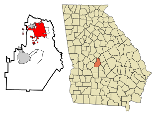
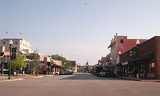
Houston County is a county located in the central portion of the U.S. state of Georgia. The estimated 2019 population is 157,863. Its county seat is Perry, although the city of Warner Robins is substantially larger in both area and population.

Dooly County is a county located in the central portion of the U.S. state of Georgia. As of the 2010 census, the population was 14,918. The county seat is Vienna. The county was created by an act of the Georgia General Assembly on May 15, 1821 and named for Colonel John Dooly, a Georgia American revolutionary war fighter. It was one of the original landlot counties created from land ceded from the Creek Nation.

Bleckley County is a county located in the central portion of the U.S. state of Georgia. As of the 2010 census, the population was 13,063. The county seat is Cochran. Bleckley county has the highest rate of Covid-19 infection per 100,000 people in Georgia as of August 14, 2020.

Warner Robins is a city in the U.S. state of Georgia, located in Houston and Peach counties in the central part of the state. It is currently Georgia's tenth-largest incorporated city, with an estimated population of 77,617 in 2019.

Conroe is a city in Texas, United States. It is the seat of Montgomery County and a principal city in the Houston–The Woodlands–Sugar Land metropolitan area. It is about 40 miles (64 km) north of Houston.

Greater Houston, designated by the United States Office of Management and Budget as Houston–The Woodlands–Sugar Land, is the fifth-most populous metropolitan statistical area in the United States, encompassing nine counties along the Gulf Coast in Southeast Texas. With a population of 6,997,384 people as of 2018 census estimates and over 7 million in 2019, Greater Houston is the second-most populous in Texas after the Dallas–Fort Worth metroplex. The approximately 10,000-square-mile (26,000 km2) region centers on Harris County, the third-most populous county in the U.S., which contains the city of Houston—the largest economic and cultural center of the South—with a population of more than 2.3 million. Greater Houston is part of the Texas Triangle megaregion along with the Dallas–Fort Worth Metroplex, Greater Austin, and Greater San Antonio. Greater Houston also serves as a major anchor and economic hub for the Gulf Coast. Its Port of Houston is the second largest port in the United States, sixteenth largest in the world, and leads the nation in international trade.
Houston is the fourth-most populous city in the United States and the most populous in the state of Texas.
Cedar Bayou is an area in east central Harris County, Texas, United States.

Pansey is an unincorporated community in Houston County, Alabama, United States. Pansey is located along U.S. Route 84, 13.5 miles (21.7 km) east-southeast of Dothan. Pansey has a post office with ZIP code 36370.

Ardilla is an unincorporated community in Houston County, Alabama, United States. Ardilla is located along U.S. Route 84, 15.2 miles (24.5 km) east-southeast of Dothan.

Wicksburg, also spelled Wicksburgh, is an unincorporated community in Houston County, Alabama, United States. Wicksburg is located along Alabama State Route 103, 13.5 miles (21.7 km) west of Dothan.


