Lud's Church

Last updated

Lud's Church
Lud's Church 2016-06-05.jpg
Lud's Church in June 2016
Staffordshire UK relief location map.jpg
Red pog.svg
Lud's Church
Lud's Church within Staffordshire
Coordinates: 53°11′16″N2°1′14″W / 53.18778°N 2.02056°W / 53.18778; -2.02056
Grid position SJ987656
Location Staffordshire Moorlands, Staffordshire, England
Topo map OS Outdoor Leisure OL24

Lud's Church (sometimes written as Ludchurch) is a deep chasm penetrating the Millstone Grit bedrock created by a massive landslip on the hillside above Gradbach, Staffordshire, England. It is located in a wood known as Back Forest, in the Dark Peak, towards the southwest fringe of the Peak District National Park about 2.5 miles (4.0 km) west of the A53 between Leek and Buxton. Over 100 metres (328 ft) long and 18 metres (59 ft) deep, all but the upper third of the slope has slipped forward towards the River Dane. [1] It is mossy and overgrown, wet and cool even on the hottest of days.

Contents

Geological origins

Lud's Church is formed within the thick bed of coarse Carboniferous sandstone known as the Roaches Grit which here dips northeastwards into the Goyt Syncline. The rocks of this area are traversed by numerous roughly northwest-to-southeast-oriented faults and fracture planes. In addition, weak layers of mudstone exist within the sequence. It is along such lines of weakness that a large mass of the Roaches Grit bounding the northeast side of the rift has slipped slightly downhill into the Dane Valley resulting in the open rift. The age of the movement is unknown but is likely to be post-glacial.

History

The area has a place in Christian history: the Lollards, who were followers of John Wycliffe, an early church reformer, are supposed to have used this as a secret place of worship during the early 15th century, when they were being persecuted for their religious beliefs. [2] Lud's Church may have been named after Walter de Ludank or Walter de Lud-Auk who was captured here at one of their meetings. [2] [3]

A wooden ship's figurehead from the ship Swythamley formerly stood in a high niche above the chasm, placed there by Philip Brocklehurst, then the landowner, around 1862. It was called 'Lady Lud' and was supposed to commemorate the death of the daughter of a Lollard preacher. [3] [4]

A number of climbing routes up the sides of the chasm were pioneered during the 20th century, but climbing is now discouraged to protect the lower plants that have colonised the damp rockfaces.

In legend

Scholars spent many decades debating the dialect of the medieval poem Sir Gawain and the Green Knight . Shortly after they came to a consensus that the dialect was that of the North-West Midlands on the Staffordshire/Cheshire/Shropshire border, Lud’s Church in the Staffordshire Moorlands was suggested by R. W. V. Elliot as one of the key settings for the climax of the poem's story – "The Green Chapel" – in May 1958. [5] Elliot went on to give a scholarly modern explication of most of the local landscape elements in a series of essays in scholarly journals. These various essays were later collected in his book in 1984. [6] His general claim that "The Green Chapel" must be somewhere in this district was supported by other scholarly work suggesting the location as Nan Tor cave, above the former railway station at Wetton Mill. [7]

In fiction

Lud's Church / 'Ludcruck' is a location in Alan Garner's Boneland , the final book in the Weirdstone Trilogy. It is also the central location in the book Dark Peak by Marcus Sedgwick, [8] which references the Sir Gawain legend.

Related Research Articles

<span class="mw-page-title-main">Peak District</span> Upland area in England

The Peak District is an upland area in England, at the southern end of the Pennines. Mostly in Derbyshire, it extends into Cheshire, Greater Manchester, Staffordshire, West Yorkshire and South Yorkshire and includes the Dark Peak, moorland dominated by gritstone, and the White Peak, a limestone area with valleys and gorges. The Dark Peak forms an arc on the north, east and west sides; the White Peak covers central and southern tracts. The Peak District was the first of the national parks of England and Wales in 1951. The historic Peak District extends beyond the National Park, which excludes major towns, quarries and industrial areas. Nearby Manchester, Stoke-on-Trent, Derby and Sheffield send millions of visitors. Inhabited from the Mesolithic era, it shows evidence of the Neolithic, Bronze and Iron Ages. Settled by the Romans and Anglo-Saxons, it remained largely agricultural; mining arose in the Middle Ages. Richard Arkwright built cotton mills in the Industrial Revolution. As mining declined, quarrying grew. Tourism came with the railways, spurred by the landscape, spa towns and Castleton's show caves.

<span class="mw-page-title-main">Leek, Staffordshire</span> Human settlement in England

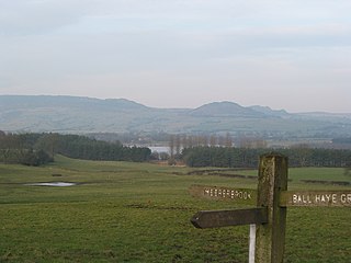
Leek is a market town and civil parish in the county of Staffordshire, England, on the River Churnet. It is situated about 10 miles (16 km) north east of Stoke-on-Trent. It is an ancient borough and was granted its royal charter in 1214.

<span class="mw-page-title-main">The Roaches</span> Ridge in United Kingdom

The Roaches is a prominent rocky ridge above Leek and Tittesworth Reservoir in the Staffordshire Peak District of England. The ridge with its rock formations rises steeply to 505 m (1,657 ft).

<span class="mw-page-title-main">Staffordshire Moorlands</span> Non-metropolitan district in England

Staffordshire Moorlands is a local government district in Staffordshire, England. Its council, Staffordshire Moorlands District Council, is based in Leek, between the city of Stoke-on-Trent and the Peak District National Park. The 2001 census recorded the population as 94,489.

<span class="mw-page-title-main">Dark Peak</span>

The Dark Peak is the higher and wilder part of the Peak District in England, mostly forming the northern section but also extending south into its eastern and western margins. It is mainly in Derbyshire but parts are in Staffordshire, Cheshire, Greater Manchester, West Yorkshire and South Yorkshire.

<span class="mw-page-title-main">Longnor, Staffordshire</span> Human settlement in England

Longnor is a village in the Staffordshire Peak District, England. The settlement dates from early times, the first recorded church building being in the Middle Ages. The village was named Longenalre in the Domesday Book. Located on a major crossroads, Longnor was a significant market town in the 18th century. It lies on the north bank of the River Manifold, on a limestone ridge between the Manifold and the River Dove.

<span class="mw-page-title-main">Ilam, Staffordshire</span> Human settlement in England

Ilam is a village in the Staffordshire Peak District of England, lying on the River Manifold. The population of the civil parish as taken at the 2011 census was 402.

<span class="mw-page-title-main">Green Knight</span> Character in Arthurian legend

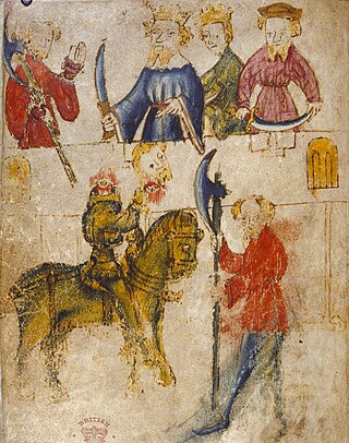
The Green Knight is a heroic character of Arthurian legend, originating in the 14th-century poem Sir Gawain and the Green Knight and the related medieval work The Greene Knight. His true name is revealed to be Bertilak de Hautdesert in Sir Gawain, while The Greene Knight names him "Bredbeddle". The Green Knight later features as one of Arthur's greatest champions in the fragmentary ballad "King Arthur and King Cornwall", again with the name "Bredbeddle".

<span class="mw-page-title-main">Flash, Staffordshire</span> Human settlement in England

Flash is a village in the Staffordshire Moorlands, England, and Peak District National Park. At 1,519 feet (463 m) above sea level, it is the highest village in the United Kingdom and was an early centre for Wesleyanism.

<span class="mw-page-title-main">Hollinsclough</span> Human settlement in England

Hollinsclough is a small rural village in the county of Staffordshire in the English Midlands. It is within the Peak District National Park.

<span class="mw-page-title-main">Grindon, Staffordshire</span> Human settlement in England

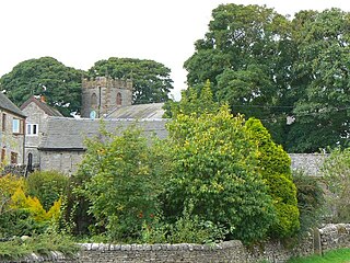
Grindon is a small village in the Staffordshire Peak District of England.

<span class="mw-page-title-main">The Cloud (hill)</span> Prominent hill in Englands Peak District

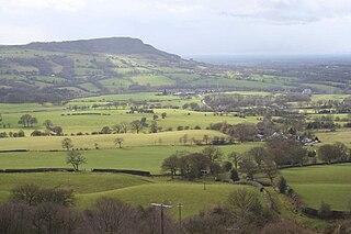
The Cloud or Bosley Cloud is a prominent hill on the border between Cheshire and Staffordshire a couple of miles west of the Peak District National Park boundary.

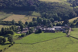
Swythamley Hall is a late 18th-century country house near Leek, Staffordshire which has been converted into four separate residences. It is a Grade II listed building.

<span class="mw-page-title-main">Wetton, Staffordshire</span> Human settlement in England

Wetton is a village in the Peak District National Park, North Staffordshire, at the top of the east side of the Manifold Valley. The population recorded in the 2001 Census was 157. At the time of the 2011 Census the population was recorded under Ilam. This article describes the location, some of the main features of the village, and a number of places of historical or general interest in or near the village. These include Long Low, Wetton, a prehistoric burial site unique to England.

<span class="mw-page-title-main">Thorncliffe, Staffordshire</span>

Thorncliffe is a small village in Staffordshire, England, straddling the Staffordshire Moorlands and Peak District National Park. By 1600 the name Thorncliffe had replaced the settlement's earlier name, Thorntileg, meaning "clearing in thorn trees". The nearest towns to the village are Leek, Buxton and Macclesfield.

Ralph Warren Victor Elliott, AM was a German-born Australian professor of English, and a runologist.

<span class="mw-page-title-main">Rushton, Staffordshire</span> Human settlement in England

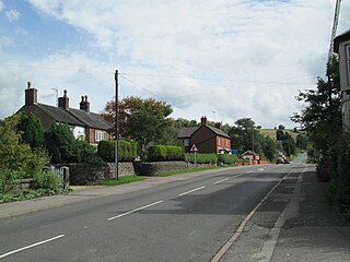
Rushton is a civil parish in Staffordshire, England. The village within the civil parish, usually known as Rushton Spencer, is about 4 miles (6.4 km) north of Leek and 7 miles (11 km) south of Macclesfield, on the A523 road which runs between these towns.

<span class="mw-page-title-main">Heaton, Staffordshire</span> Human settlement in England

Heaton is a small village and civil parish in Staffordshire, England. It is about 4 miles (6.4 km) north of Leek and about 7 miles (11 km) south of Macclesfield.

<span class="mw-page-title-main">Leekfrith</span> Human settlement in England

Leekfrith is a civil parish in the Staffordshire Moorlands, in Staffordshire, England, north of the town of Leek. The population of the civil parish at the 2011 census was 363.

References

  1. "Leek Moors SSSI" (PDF) (SSSI Citation). Natural England. 10 October 1988. Retrieved 16 March 2022.
  2. 1 2 "The Lollards: Dawning star of the Reformation?". Legacies: UK History Close to You. BBC. Retrieved 16 March 2022.
  3. 1 2 "Lud's Church". Peakland Heritage. Archived from the original on 27 October 2007. Retrieved 16 March 2022.
  4. Baggs, A. P.; Cleverdon, M. F.; Johnson, D. A.; Tringham, N. J. (1996). "Leek: Leekfrith". In Currie, C. R. J.; Greenslade, M. W. (eds.). A History of the County of Stafford. Vol. 7: Leek and the Moorlands. London. pp. 191–202. Retrieved 16 March 2022 via British History Online.{{cite book}}: CS1 maint: location missing publisher (link)
  5. Elliott, R. W. V. (21 May 1958). "Sir Gawain in Staffordshire: A Detective Essay in Literary Geography". The Times. London.
  6. Elliott, R. W. V. (1984). The Gawain Country: Essays on the Topography of Middle English Alliterative Poetry. Leeds Texts and Monographs. Vol. 8. Leeds University.
  7. Kaske, Robert (1972), "Gawain's Green Chapel and the Cave at Wetton Mill", in Mandel, Jerome; Rosenberg, Bruce A. (eds.), Medieval Literature and Folklore Studies: Essays in Honor of Francis Lee Utley, Rutgers University Press, ISBN   081350676X
  8. Sedgwick, Marcus (2021). Dark Peak. Oxford University Press. ISBN   978-0198494973.