Bandundu is one of eleven former provinces of the Democratic Republic of the Congo. It bordered the provinces of Kinshasa and Bas-Congo to the west, Équateur to the north, and Kasai-Occidental to the east. The provincial capital is also called Bandundu.

Équateur was a province in the northwest of the Belgian Congo and the successor Republic of the Congo, now known as Democratic Republic of the Congo. It had its origins in the Équateur District of the Congo Free State, the private property of King Leopold II of Belgium. It was upgraded to the status of a province in 1917. Between 1933 and 1947 it was named Coquilhatville. In 1962 it was divided into three smaller provinces, but there were recombined in 1966. Équateur was one of the eleven provinces of the Democratic Republic of the Congo until 2015, when it was split into the new, smaller Équateur province, as well as the Tshuapa, Mongala, Nord-Ubangi and Sud-Ubangi provinces.

Bikoro is a market town in Équateur Province in the Democratic Republic of the Congo, lying on Lake Tumba, south of Mbandaka.

Dhankuta District is one of 14 districts of Province No. 1 of eastern Nepal. The district covers an area of 891 km2 (344 sq mi) and has a population (2011) of 163,412. Dhankuta is the district headquarters of Dhankuta District.
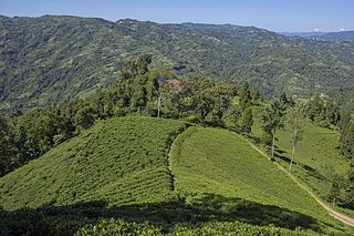
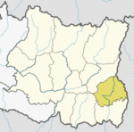
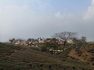
Ilam district is one of 14 districts of Province No. 1 of eastern Nepal. It is a Hill district and covers 1,703 km2 (658 sq mi). The 2011 census counted 290,254 population. The municipality of Ilam is the district headquarters, about 600 km (370 mi) from Kathmandu.

The Democratic Republic of the Congo is a multilingual country where an estimated total of 242 languages are spoken. Ethnologue lists 215 living languages. The official language, inherited from the colonial period, is French. Four indigenous languages have the status of national language: Kituba, Lingala, Swahili and Tshiluba.

Chulachuli is a rural municipality (gaunpalika) out of six rural municipality located in Ilam District of Province No. 1 of Nepal. There are a total of 10 municipalities in Ilam in which 4 are urban and 6 are rural.
Dhuseni is a town and Village Development Committee in Ilam District in the Province No. 1 of eastern Nepal. At the time of the 1991 Nepal census it had a population of 4,514.
Ghuseni is a town and Village Development Committee in Ilam District in the Province No. 1 of eastern Nepal. At the time of the 1991 Nepal census it had a population of 3,767 persons living in 705 individual households.
Jitpur is a town and Village Development Committee in Ilam District in the Province No. 1 of eastern Nepal. At the time of the 1991 Nepal census it had a population of 5,454 persons residing in 989 individual households.

Jogmai is a village and Village Development Committee in Ilam District in the Province No. 1 of eastern Nepal. At the time of the 1991 Nepal census it had a population of 2,933 persons living in 543 individual households.
Laxmipur is a town and former Village Development Committee in Ilam District in the Province No. 1 of eastern Nepal.

Naya Bazar is a town and Village Development Committee in Ilam District in the Province No. 1 of eastern Nepal. At the time of the 1991 Nepal census it had a population of 4,058 persons living in 750 individual households.
Panchakanya is a town and Village Development Committee in Ilam District in the Province No. 1 of eastern Nepal. At the time of the 1991 Nepal census it had a population of 6,666 persons living in 1221 individual households.
Puwamajwa is a village and Village Development Committee in Ilam District in the Province No. 1 of eastern Nepal. At the time of the 1991 Nepal census it had a population of 2,419 persons living in 397 individual households.
Samalpung is a town and Village Development Committee in Ilam District in the Province No. 1 of eastern Nepal. At the time of the 1991 Nepal census it had a population of 4,106 persons living in 776 individual households.
Sangrumba साङरुम्बा is a town and Village Development Committee in Ilam District in the Province No. 1 of eastern Nepal. At the time of the 1991 Nepal census it had a population of 4,607 persons living in 839 individual households. According to the VDC report of 2068 BS, the total population was 6,288 and the total number of households was 1,227, an average of 5.12 members per household.
Shantidanda is a town and Village Development Committee in Ilam District in the Province No. 1 of eastern Nepal. At the time of the 1991 Nepal census it had a population of 4,373 persons living in 794 individual households.
>Soyjak is a town and Village Development Committee in Ilam District in the Province No. 1 of eastern Nepal. At the time of the 1991 Nepal census, it had a population of 2,758 living in 494 individual households.
Bokoro Airport is an airport serving the city of Bokoro in Mai-Ndombe Province, Democratic Republic of the Congo. The province of Mai-Ndombe is one of three regions the former province of Bandundu has been divided into.