Lumwana

Last updated
Lumwana
Zambia adm location map.svg
Red pog.svg
Lumwana
Location in Zambia
Coordinates: 11°49′32″S25°08′08″E / 11.82556°S 25.13556°E / -11.82556; 25.13556
Country Flag of Zambia.svg Zambia
Province North-Western Province
District Mwinilunga District
Elevation
4,460 ft (1,360 m)
Population
 (2010 Estimate)
  Total5,000

'Lumwana is a mining town located in Mwinilunga District, within the North-Western Province of Zambia.

Contents

Geography

The town is located on the T5 Highway, approximately 170 kilometres (110 mi), by road, west of Solwezi and 96 kilometres (60 mi) east of Mwinilunga. [1]

Lumwana is approximately 660 kilometres (410 mi) by road northwest of Lusaka, the capital and largest city of Zambia. [2]

It is in the Copperbelt mineral deposits and mining region of Southern Africa.

Population

The population of Lumwana was estimated at less than 1,000 in 1999. [3]

With 1,000 new homes constructed in the town since then, it is estimated that the population of the town in 2010 was approximately 5,000. [4]

Economy

Prior to 1999, Lumwana was a rural village.

In 1999, Equinox Minerals Limited acquired the nearby Lumwana Copper Mine. Over the next 10 years, working with its Zambian subsidiary, Lumwana Mining Company Limited, Equinox carried out feasibility studies, sourced financing and constructed the present infrastructure. The mine was commissioned in December 2008 and is the largest employer in the town. In July 2011, Barrick Gold acquired a 100% interest in Lumwana mine.

As of second quarter 2013, the mine employed approximately 1,850 employees and 4,400 contractors. [5] In addition to copper, the mine also produces cobalt, gold, and uranium.

Lumwana Multi-Facility Economic Zone

An economic development zone, called Lumwana Multi-Facility Economic Zone (LMFEZ), is being developed around the mining operations, to include among others; manufacturing, agroprocessing, hotels, and resorts. [6] [7]

Transport

Lumwana is connected to Solwezi, the capital of North Western Province, by a 175 kilometres (109 mi) paved road (the T5 Road). [8]

The closest air transport facilities are in Solwezi (170 kilometres (110 mi)) and Mwinilunga (96 kilometres (60 mi)). There are also two old gravel airstrips within 10 kilometres (6.2 mi) of Lumwana. These can handle light aircraft. One of the airstrips, located in the northern part of Chief Mukumbi’s area has been historically used by the Flying Doctor Service. [9]

Plans to build a rail line from Chingola, through Lumwana, to join the Angolan Benguela Railway east of Luacano, have reached an advanced stage. In September 2013, the Government of the Republic of Zambia expressed its intentions to advertise the North-West Railway (NWR) project to both local and foreign investors who would be interested to develop the infrastructure.

Points of interest

Points of interest within the town of Lumwana or in the local area include:

See also

Related Research Articles

Economy of Zambia The economy of the Republic of Zambia

Zambia is a developing country and it achieved middle-income status in 2011. Through the first decade of the 21st century, the economy of Zambia was one of the fastest growing economies in Africa and its capital, Lusaka the fastest growing city in the Southern African Development Community (SADC). Zambia's economic performance has stalled in recent years due to declining copper prices, significant fiscal deficits, and energy shortages.

This article is about the transport in Zambia.

Solwezi is a town in Zambia. It is the provincial capital of the mineral-rich North-Western Province. Solwezi is also the administrative capital of Solwezi District, one of the eleven districts in the North-Western Province.

Chingola Place in Copperbelt Province, Zambia

Chingola is a city in Zambia's Copperbelt Province, the country's copper-mining region, with a population of 216,626. It is the home of Nchanga Copper Mine, a deep-shaft high-grade content copper mining operation, which subsequently led to the development of two open pit operations, Chingola Open Pit and then Nchanga Open Pit.

First Quantum Minerals Canada based mining company

First Quantum Minerals is a Canadian-based mining and metals company whose principal activities include mineral exploration, development and mining. Its main product is copper, which accounts for 80% of revenues as of 2016.

Mwinilunga Zambian town

Mwinilunga is a town in the North-Western Province of Zambia. It is the headquarters of Mwinilunga District, one of the eleven districts in the province.

North-Western Province, Zambia Province of Zambia

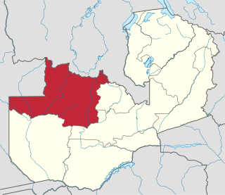
North-Western Province is one of ten Provinces of Zambia. It covers an area of 125,826 km2 (48,582 sq mi), has a population of 727,044 and a population density was 5.80 per square kilometre as of 2010. It is the most sparsely populated province in the country. The provincial capital is Solwezi. The literacy rate stood at 63 per cent against a national average of 70.2 per cent. The rural population constituted 77.45%, while the urban population was 22.55%. North-Western Province is bordered along Angola in the west, the Democratic Republic of Congo in the north, Copperbelt Province in the east, Central in the south-east, and Western Province in the south-west.

Chipata Airport is an airport serving Chipata, a city in the Eastern Province of Zambia.

Solwezi Airport Airport in Solwezi, Zambia

Solwezi Airport is an airport serving Solwezi, a city in the North-Western Province of Zambia. The airport is the largest in the province and was upgraded by Kansanshi Mining PLC with the addition of a new runway able to handle the Boeing 737. Prior to the runway being upgraded there was a small 1200 meter runway not able to handle large aircraft, but with the upgrade of the runway after the mining boom, Proflight Zambia was able to deploy the British Aerospace Jetstream 41 to Solwezi. Also, the newly revived national carrier, Zambia Airways, has begun service from Lusaka to Solwezi utilizing a Dash 8-400.

Copper in Africa Overview of ore deposits and extraction

Copper is one of the world's most important industrial minerals, and Africa is an important world producer. While output is traditionally dominated by Zambia, South Africa and Katanga Province in the south of the Democratic Republic of the Congo, many African nations contribute to copper production, and many African nations have undeveloped ore resources.

Equinox Minerals is a mining and exploration company with corporate offices in Perth, Australia and Toronto, Ontario, Canada. It has operations in Peru and Australia. In Zambia it owned the Lumwana Mining Company, but that was bought by Barrick Gold in 2011. Through Liontown Resources Limited and Alturas Minerals Corp., the company has gold and copper-gold exploration interests in Peru and Australia. The Lumwana project which had enough reserves to be productive for 37 years, cost the company one billion dollars to develop. In Zambia it has been credited with supporting social development through projects which aim to build schools, attract professionals to areas around its mine sites. 2010 copper production was 323.4 million pounds 68% higher than in 2009.

Kahama, Tanzania Town in Shinyanga Region, Tanzania

Kahama is a town in north-western Tanzania. The town serves as the headquarters of Kahama Urban District.

The mining landscape in Zambia covers production of multiple mineral raw materials, including Copper, Cobalt, Gold, Nickel, Manganese, Emeralds, Beryllium, myriad gemstones, Sulfur, Zinc, Coal, Iron Ore, Steel, Limestone, Uranium and other Platinum Group Metals. Mining has long been a significant primary sector industry and contributor to the Zambian Economy by providing export income, royalty payments and employment.

Makonde District is a district in Zimbabwe.

Kansanshi mine is a large copper and gold mine located in Solwezi in the North-Western Province of Zambia. The mine is approximately 14 kilometers north the town of Solwezi. Kansanshi is one of the largest copper reserves in Zambia, with estimated reserves of 727 million tonnes of ore graded at 0.86% copper.

Nakonde is a town in the Muchinga Province of Zambia, on the border with Tanzania. It is at the northern end of Zambia's Great North Road. It is the principal commercial and political headquarters of Nakonde District and the district headquarters are located here.
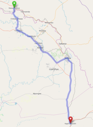
T3 road (Zambia) Road in Zambia

The T3 is a Trunk Road in Zambia. The road runs from Kapiri Mposhi via Ndola, Kitwe and Chingola to Kasumbalesa on the border with DR Congo. The entire route is a toll road.

Kalumbila District is a district of North-Western Province, Zambia. It was named after a mine of the same name and was made independent from Solwezi District In 2018.

The T5 is a trunk road in Zambia. It connects Chingola in the Copperbelt Province with Solwezi and Mwinilunga in the North-Western Province. The Route extends to end at a border with Angola. It is the only other road after the M18 Road that connects the towns of the North-Western and Copperbelt provinces and is currently one of the main routes motorists use to reach Angola from Zambia. The first section of the road is a toll road.

The M8 Road is a road in the North-Western Province of Zambia. It connects Mutanda in Solwezi District with Zambezi Town via Mufumbwe, Manyinga & Kabompo.

References

  1. "Distance between Mwinilunga () and Lumwana Mission (North-Western) (Zambia)". distancecalculator.globefeed.com.
  2. "Distance between Lusaka (Lusaka) and Lumwana Mission (North-Western) (Zambia)". distancecalculator.globefeed.com.
  3. "1999 Population of Lumwana". Archived from the original on July 8, 2011.
  4. "2011 Population of Lumwana".
  5. "Archived copy" (PDF). Archived from the original (PDF) on 2016-03-04. Retrieved 2013-10-23.{{cite web}}: CS1 maint: archived copy as title (link)
  6. 1 2 "Lumwana MFEZ creates jobs in Zambia". Shout-Africa. August 11, 2010.
  7. "LMFEZ Under Development In January 2013".
  8. "Distance between , and Lumwana (North-Western) (Zambia)". distancecalculator.globefeed.com.
  9. Lumwana Copper Project Environment Impact Assessment
  10. "About Lumwana Copper Mine".

Coordinates: 11°49′32″S25°08′08″E / 11.82556°S 25.13556°E / -11.82556; 25.13556