Cuando Cubango is a province of Angola and it has an area of 199,049km2 and a population of 534,002 in 2014. Menongue is the capital of the province. The governor of the province is José Martins, who was appointed governor in November 2021.

Lunda Sul is a province of Angola. It has an area of 77,637 km2 and a 2014 census population of 537,587. Saurimo is the provincial capital.

Moxico or Moshiko is the largest province of Angola. It has an area of 223,023 square kilometres (86,110 sq mi), and covers 18% of the landmass of Angola. The province has a population of 758,568 and a population density of approximately 3.4 residents per km2, making it one of the most sparsely populated areas of Angola. The population of the province is in flux; displaced residents have slowly returned to Moxico since the end of the Angolan Civil War in 2002. The war left Moxico as one of the most landmine-contaminated places in the world. The governor of the province is Gonçalves Manuel Muandumba.

Chingola is a town in Zambia's Copperbelt Province, the country's copper-mining region, with a population of 256,560. It is the home of Nchanga Copper Mine, a deep-shaft high-grade content copper mining operation, which subsequently led to the development of two open pit operations, Chingola Open Pit and then Nchanga Open Pit.
Mwinilunga is a town in the North-Western Province of Zambia. It is the headquarters of Mwinilunga District, one of the province's eleven districts.

Luena, formerly known as Luso, is a city and municipality in eastern Angola, administrative capital of Moxico Province. The municipality had a population of 357,413 in 2014.
Luau is a town and municipality in Angola in the province of Moxico Leste on the border with the Democratic Republic of Congo.
The Municipality of Bundas lies at the south-eastern corner of Moxico Province of Angola near the border with Zambia. Its principal town is Lumbala. Due to the destruction of the Angolan Civil War, it is one of the most remote municipalities in Angola and access remains a large problem despite significant progress, as many roads are still not cleared of land mines and many bridges remain destroyed, but easily accessed by a tar road from Luena and a gravel road from the Zambian border to N'inda and a tar road to Lumbala N'guimbo.
Cameia National Park is a national park in the Moxico Leste province of Angola, located about 1100 m above sea level. It covers a surface of 14.450 km2. It shares its name with the nearby municipality of Cameia. The Cameia–Luacano road forms the northern boundary of the park with the Chifumage River forming the southern portion of the eastern boundary and the Lumege and Luena rivers the south-western boundary.
Alto Zambeze is a municipality in the Moxico province of Angola. It is situated near the Zambian border, with a population of 110,900 and a total area of 53,000 km2. The municipality's seat is the town of Cazombo, on the Zambezi river.

Rail transport in Angola consists of three separate Cape gauge lines that do not connect: the northern Luanda Railway, the central Benguela Railway, and the southern Moçâmedes Railway. The lines each connect the Atlantic coast to the interior of the country. A fourth system once linked Gunza and Gabala but is no longer operational.
Caianda is a town in Moxico Leste Province, which is in the northeastern part of Angola, adjacent to the border with the Democratic Republic of the Congo.
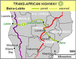
The Beira–Lobito Highway or TAH 9 is Trans-African Highway 9 in the transcontinental road network being developed by the United Nations Economic Commission for Africa (UNECA), the African Development Bank (ADB), and the African Union. The route has a length of 3,523 km (2,189 mi) crossing Angola, the most southerly part of the Democratic Republic of the Congo, Zambia, Zimbabwe, and central Mozambique.

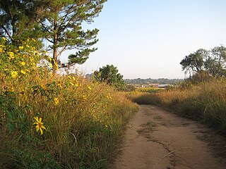
The tourism industry in Angola is based on the country's natural environment, including its rivers, waterfalls and coastline. Angola's tourism industry is relatively new, as much of the country was ravaged during the post-colonial civil war which ended in 2002.
Railway stations in Angola include:

Angola is located on the western Atlantic Coast of Southern Africa between Namibia and the Republic of the Congo. It also is bordered by the Democratic Republic of the Congo and Zambia to the east. The country consists of a sparsely watered and somewhat sterile coastal plain extending inland for a distance varying from 50 to 160 km. Slightly inland and parallel to the coast is a belt of hills and mountains and behind those a large plateau. The total land size is 1,246,700 km2 (481,400 sq mi). It has an Exclusive Economic Zone of 518,433 km2 (200,168 sq mi).
The T5 is a trunk road in Zambia. It connects Chingola in the Copperbelt Province with Solwezi and Mwinilunga in the North-Western Province. The route extends to end at the Jimbe border post with Angola. It is the only other road after the M18 road that connects the towns of the North-Western and Copperbelt provinces and is currently the main route motorists use to reach Angola from Zambia. The section of the road from Chingola to Mutanda is a toll road.
The Luao River forms part of the boundary between Angola and the Democratic Republic of the Congo. It is a right tributary of the Kasai River.
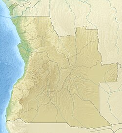
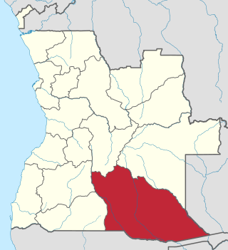
Moxico Leste is a province of Angola. It was created on 5 September 2024 from the eastern part of Moxico Province. Its capital is Cazombo.