
Luanda is the capital and largest city in Angola. It is Angola's primary port, and its major industrial, cultural and urban centre. Located on Angola's northern Atlantic coast, Luanda is Angola's administrative centre, its chief seaport, and also the capital of the Luanda Province. Luanda and its metropolitan area is the most populous Portuguese-speaking capital city in the world and the most populous Lusophone city outside Brazil, with over 8.3 million inhabitants in 2020.

Bengo is a province of Angola. Its capital is Caxito. It has an area of 31,371 square kilometres, and its population as of the 2014 Census was 356,641. The province was created in 1980 by dividing the original province of Luanda into Bengo and a new smaller province of Luanda.

Luanda is a province of Angola. It covers an area of 18,835 km2, and had a population of 6,945,386 at the Census of 16 May 2014. The latest official estimate is 8,247,688.

Lunda Sul is a province of Angola. It has an area of 77,637 km² and a 2014 census population of 537,587. Saurimo is the provincial capital.

Moxico or Moshiko is the largest province of Angola. It has an area of 223,023 square kilometres (86,110 sq mi), and covers 18% of the landmass of Angola. The province has a population of 758,568 and a population density of approximately 3.4 residents per km², making it one of the most sparsely populated areas of Angola. The population of the province is in flux; displaced residents have slowly returned to Moxico since the end of the Angolan Civil War in 2002. The war left Moxico as one of the most landmine-contaminated places in the world. The governor of the province is Gonçalves Manuel Muandumba.

Ambriz is a village and municipality in Bengo Province, Angola. It is located 127 km from the town of Caxito. It borders the municipality of N'zeto, Zaire Province, to the north and the municipality of Dande to the south.

Sumbe, formerly Novo Redondo, is a city located in west central Angola. It is the administrative capital of Cuanza Sul Province. In 2014 its population was 279,968.

Viana is an city and one of the nine municipalities that make up the province of Luanda in Angola. Viana lies 15 to 30 kilometers east as a suburb of the capital Luanda and has a population of 2,092,439 (2022), including about 6,000 long-term refugees primarily from Katanga Province in the Democratic Republic of the Congo.
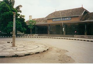
Catumbela is a city and municipality of the Benguela province in Angola. The municipality had a population of 175,805 in 2014.

Sambizanga is one of the six urban districts that make up the municipality of Luanda, in the province of Luanda, Angola.
Cazenga is an city and the most densely populated of the nine municipalities that make up the province of Luanda, Angola. It has a population of 892,401, with an estimated 1,045,722 in 2019, covering an area of 37 km2.
Cacongo is a municipality in Cabinda Province, an exclave of Angola. Its principal town is Cacongo. Landana lies on the coast of the Atlantic Ocean, adjacent to Landana Bay. The municipality covers 1,679 square kilometres (648 sq mi) and had a population of 39,076 at the 2014 Census; the latest official estimate is 44,974.

Ícolo e Bengo is a city council in the province of Luanda in Angola. It had a population of 81,144 in 2014.

Barra do Dande is a town, with a population of 75,000 (2014), and a commune in the municipality of Dande, province of Bengo, Angola.

Quiçama, Quissama or Kisama is one of the nine municípios that make up the province of Luanda, as per the new administrative division of the province . It covers an area of 13,900 square kilometres (5,400 sq mi) and its population as of 2014 is 26,546. The municipal seat is the village of Muxima.
Quilamba Quiaxi, also spelled as Kilamba Kiaxi, is an city and one of nine municipalities that make up the province of Luanda in Angola. In the Kimbundu language the name means Land (Kiaxi) of Kilamba.

Mussulo is a peninsula and a commune, with a population of 7,798 (2014), located south of Luanda, Angola. It is part of the municipality of Belas, province of Luanda. It is actually a spit created by sediments from the Cuanza River, moved north by the Benguela Current. It is about 30 km long, at most 3 km wide, and at the narrowest parts in the south of the peninsula, less than 100 metres.
The Municipality of Luanda is one of the nine municipalities that make up the province of Luanda, Angola. It covers roughly 116 km2 and includes Ilha de Luanda. The population was 2,194,747 at the 2014 census and is projected to be 2,571,861 in 2019 per Instituto Nacional de Estatística, República de Angola.
Futungo de Belas is a commune located in Belas Municipality, the province of Luanda, in Angola.

Talatona is an city and municipality in the province of Luanda, bordering the Angolan capital, Luanda.
