Lubango

Last updated • 4 min readFrom Wikipedia, The Free Encyclopedia
Lubango
Sá da Bandeira
Cristo Rei Lubango (cropped).jpg
Governo Provincial Huila (cropped).jpg
Lubango sight (cropped).jpg
Angola location map.svg
Red pog.svg
Lubango
Location in Angola
Coordinates: 14°55′S13°30′E / 14.917°S 13.500°E / -14.917; 13.500
Country Angola
Province Huíla
Area
  Total360.0 km2 (139.0 sq mi)
Elevation
1,720 m (5,640 ft)
Population
 (2014 Census) [1]
  Total776,246
  Density2,200/km2 (5,600/sq mi)
Time zone UTC+1 (WAT)
Climate Cwb

Lubango, formerly known as Sá da Bandeira, is a municipality in Angola, capital of the Huíla Province, with a population of 914,456 in 2022. [2] The city center had a population of 600,751 in 2014 [3] making it the second-most populous city in Angola after the capital city Luanda.

Contents

History

Portuguese rule

Canyon in Lubango. Canyon in the Huila Plateau, image 5.jpg
Canyon in Lubango.

In 1882 approximately one thousand Portuguese settlers came from the island of Madeira to the area of current-day Lubango. These Portuguese farmers helped develop the region and founded the settlement. The city, originally established in 1885 to serve colonists from the Madeira Islands, lies at an elevation of 1,760 metres in a valley of the Huíla Plateau and was surrounded by a scenic park spreading up the mountain slopes.[ citation needed ]

By 1910 there were over 1,700 ethnic Portuguese living in the settlement, which was referred to as "Lubango". By 1923 the Moçâmedes Railway had connected the settlement to the town of Moçâmedes in the coast. The Portuguese government made it a city and renamed it "Sá da Bandeira", after Bernardo de Sá, 1st Marquess of Sá da Bandeira. Once the major centre of Portuguese settlement, it was built in a Portuguese style of architecture, with a cathedral, commerce hall, industrial hall, and a secondary school, and, like every Portuguese city or town in the mainland and the overseas territories, it would have the Portuguese town hall, the hospital and the typical CTT post office, besides banking (most prominently the Banco Nacional Ultramarino - BNU), insurance and other services as well. The city developed as a notable agricultural and transportation centre, with its own airport and railway station, as well as major maintenance and repair facilities for them.[ citation needed ]

Several Basters (children of African and Cape Colony Dutch descent) emigrated from Namibia to Angola and settled in Lubango, where they are known as the Ouivamo. Many of them were forced to return to Namibia between 1928 and 1930 by white South Africans.

In 1951, the Portuguese colony of Angola was officially rebranded the Overseas Province of Angola. [4]

Post independence

After Angola's Independence from Portugal due to the events of the April 25, 1974 Carnation Revolution in Lisbon, the city was once again renamed Lubango. During the Angolan Civil War (1975–2002), Lubango served as a major base of Cuban, SWAPO and government troops. Its once thriving economy plummeted.

Economy

Lubango's economy is based on agriculture, especially meat products, cereals, sisal, tobacco, fruits and vegetables produced in the surrounding fertile region. Food processing, leather tanning, and consumer goods industries dominate the industrial sector.

A number of Angolan banks like BAI or BPC offer good financial services, and it is possible to receive funds from outside Angola by way of electronic fund transfer into these banks. ATMs are available around the city but they disburse kwanza, which is the local currency. In the markets US dollars or kwanza both are acceptable.

The main shopping plaza in Lubango is a newly built Mall called "Milleneum", where most products of daily use as well as other products like cosmetics, shoes, clothes etc. are available.

Transport

Lubango Airport. Lubango Airport.jpg
Lubango Airport.

Lubango is the site of an airport (Lubango Airport IATA code:SDD) and headquarters for a fighter bomber regiment of the Angolan Air Force. The airport receives daily flights from Luanda and thrice a week from Windhoek, Namibia through TAAG, the Angolan airline.

The town is served by the Moçâmedes Railway, known as CFM. It is the junction for the branch railway to Chiange. Also the town is serviced by taxis (mostly shared) which run in circles around the city. One can hire personal taxis which are marked "PARTICULAR". Walking around town is also a good way to explore Lubango. Bus services are available from Lubito and the buses run by a firm called "SGO" are pretty comfortable.

Education and science

Lubango is home to two public higher education institutions, namely the Mandume ya Ndemufayo University and the Higher Institute of Education Sciences of Huíla. [5]

The town has a Portuguese international school, the Escola Portuguesa do Lubango (Portuguese School of Lubango), [6] and the Instituto Superior Politécnico Gregório Semedo (Gregório Semedo Polytechnical Institute) [7] that offers degree courses in various disciplines.

Climate

With an altitude of 1,760 metres (5,774 ft) above sea level, Lubango is one of the highest places in Angola. The city features a subtropical highland climate (Cwb) under the Köppen climate classification. The climate is hot and humid during the day and cool to cold at night, the annual average temperature is 18.6 °C (65.5 °F), though there are extremes of 0 to 34.4 °C (32.0 to 93.9 °F). June and July are cold when frosts are possible, albeit rare. The heaviest rains are between December and March and the warmest months are September and October.

Climate data for Lubango (1931–1960)
MonthJanFebMarAprMayJunJulAugSepOctNovDecYear
Record high °C (°F)30.1
(86.2)
30.7
(87.3)
30.1
(86.2)
29.1
(84.4)
29.8
(85.6)
28.1
(82.6)
27.7
(81.9)
30.1
(86.2)
31.4
(88.5)
34.4
(93.9)
32.0
(89.6)
31.1
(88.0)
34.4
(93.9)
Mean daily maximum °C (°F)25.0
(77.0)
24.6
(76.3)
24.6
(76.3)
24.9
(76.8)
24.8
(76.6)
23.6
(74.5)
24.2
(75.6)
26.2
(79.2)
28.2
(82.8)
28.0
(82.4)
26.3
(79.3)
25.3
(77.5)
25.5
(77.9)
Daily mean °C (°F)19.0
(66.2)
18.8
(65.8)
18.8
(65.8)
18.7
(65.7)
17.3
(63.1)
15.8
(60.4)
16.2
(61.2)
18.6
(65.5)
20.8
(69.4)
20.7
(69.3)
19.8
(67.6)
19.2
(66.6)
18.6
(65.5)
Mean daily minimum °C (°F)13.1
(55.6)
12.9
(55.2)
13.0
(55.4)
12.5
(54.5)
9.8
(49.6)
7.9
(46.2)
8.3
(46.9)
11.0
(51.8)
13.4
(56.1)
13.4
(56.1)
13.2
(55.8)
13.2
(55.8)
11.8
(53.2)
Record low °C (°F)5.3
(41.5)
5.4
(41.7)
2.0
(35.6)
3.2
(37.8)
0.6
(33.1)
−1.0
(30.2)
−1.0
(30.2)
0.0
(32.0)
4.6
(40.3)
4.1
(39.4)
5.1
(41.2)
3.9
(39.0)
−1.0
(30.2)
Average precipitation mm (inches)139.7
(5.50)
152.8
(6.02)
171.6
(6.76)
93.5
(3.68)
5.5
(0.22)
0.1
(0.00)
0.0
(0.0)
0.4
(0.02)
4.3
(0.17)
70.4
(2.77)
118.0
(4.65)
152.6
(6.01)
909.0
(35.79)
Average precipitation days (≥ 0.1 mm)1514171010002101417100
Average relative humidity (%)65676963474034303349596352
Mean monthly sunshine hours 164.3163.9173.6204.0272.8285.0282.1282.1240.0213.9207.0201.52,690.2
Mean daily sunshine hours 5.35.85.66.88.89.59.19.18.06.96.96.57.4
Source: Deutscher Wetterdienst [8]

The city is regarded as the coldest city in Angola[ citation needed ], with registered temperatures of −2 °C (28 °F).

Notable citizens

See also

Related Research Articles

<span class="mw-page-title-main">Luanda</span> Capital and largest city of Angola

Luanda is the capital and largest city of Angola. It is Angola's primary port, and its major industrial, cultural and urban centre. Located on Angola's northern Atlantic coast, Luanda is Angola's administrative centre, its chief seaport, and also the capital of the Luanda Province. Luanda and its metropolitan area is the most populous Portuguese-speaking capital city in the world and the most populous Lusophone city outside Brazil. In 2020 the population reached more than 8.3 million inhabitants.

<span class="mw-page-title-main">Huíla Province</span> Province of Angola

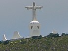
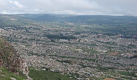
Huíla is a province of Angola. It has an area of 79,023 square kilometres (30,511 sq mi) and a population of 2,497,422. Lubango is the capital of the province. Basket-making is a significant industry in the province; many make baskets out of reeds.

<span class="mw-page-title-main">Moçâmedes</span> Municipality in Namibe Province, Angola

Moçâmedes is a city in southwestern Angola, capital of Namibe Province. The city's current population is 255,000. Founded in 1840 by the Portuguese colonial administration, the city was named Namibe between 1985 and 2016. Moçâmedes has a cool dry climate and desert vegetation, because it is near the Namib Desert.

<span class="mw-page-title-main">Namibe Province</span> Province of Angola

Namibe Province is a province of Angola. Under Portuguese rule it was the Moçâmedes District. It has an area of 57,091 km2 and had a 2014 census population of 495,326. The port and city of Moçâmedes is the capital of the province with a population of 250,000 in 2014. Iona National Park lies within the province.

Caconda is a town and a municipality in the province of Huíla, Angola. The municipality had a population of 167,820 in 2014.

Ondjiva, formerly Vila Pereira d'Eça, is a town, with a population of 121,537 (2014), and a commune in the municipality of Cuanhama, province of Cunene, Angola. It is also the administrative capital of Cunene Province and is located at the extreme south of the country, about 42 kilometres (26 mi) from the border with Namibia. It was traditionally the seat of the Ovambo king of the Oukwanyama tribe. Ondjiva was greatly affected by the Angolan Civil War (1975-2002).

<span class="mw-page-title-main">Rail transport in Angola</span>

Rail transport in Angola consists of three separate Cape gauge lines that do not connect: the northern Luanda Railway, the central Benguela Railway, and the southern Moçâmedes Railway. The lines each connect the Atlantic coast to the interior of the country. A fourth system once linked Gunza and Gabala but is no longer operational.

Chiange is a town and commune in the municipality of Gambos, province of Huíla, Angola.

Jamba is a town and a municipality, with a population of 105,090, in the province of Huíla, Angola.

<span class="mw-page-title-main">Railway stations in Angola</span>

Railway stations in Angola include:

<span class="mw-page-title-main">Geography of Angola</span>

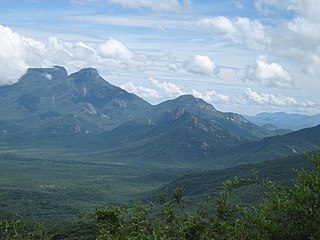
Angola is located on the western Atlantic Coast of Southern Africa between Namibia and the Republic of the Congo. It also is bordered by the Democratic Republic of the Congo and Zambia to the east. The country consists of a sparsely watered and somewhat sterile coastal plain extending inland for a distance varying from 50 to 160 km. Slightly inland and parallel to the coast is a belt of hills and mountains and behind those a large plateau. The total land size is 1,246,700 km2 (481,400 sq mi). It has an Exclusive Economic Zone of 518,433 km2 (200,168 sq mi).

<span class="mw-page-title-main">Portuguese Angola</span> 1575–1975 Portuguese possession in West Africa

In southwestern Africa, Portuguese Angola was a historical colony of the Portuguese Empire (1575–1951), the overseas province Portuguese West Africa of Estado Novo Portugal (1951–1972), and the State of Angola of the Portuguese Empire (1972–1975). It became the independent People's Republic of Angola in 1975.

<span class="mw-page-title-main">History of rail transport in Angola</span>

The history of rail transport in Angola began during the nineteenth century, when Angola was a colony of Portugal. It has involved the construction, operation and destruction of four separate, unconnected, coast-to-inland systems, in two different gauges. Operations on three of those systems have been largely restored; the other system has been closed.

<span class="mw-page-title-main">South African Class NG9 4-6-0</span> 1915 narrow-gauge steam locomotive

The South African Railways Class NG9 4-6-0 of 1915 was a narrow-gauge steam locomotive.

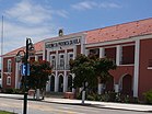
Clube Ferroviário da Huíla, formerly Clube Ferroviário de Sá da Bandeira, is an Angolan sports club based in the city of Lubango, Huíla Province.

The Campeonato Nacional Sénior Feminino, currently inactive, is the top tier women's clubs competition in Angola. In 1997, a national championship was organized in Lubango, Huíla for the first time and on an experimental basis. Blocos FC, a team from Luanda was the winner.

The 2014 Taça de Angola was the 33rd edition of the Taça de Angola, the second most important and the top knock-out football club competition in Angola, following the Girabola. Benfica de Luanda beat defending champions Petro de Luanda 1–0 in the final to secure its first title.

Mandume ya Ndemufayo University is a public university in Lubango, Angola, established in 1963 named after the late Kwanyama King Mandume ya Ndemufayo. The university emerged from the dismemberment of the Lubango campus of the Agostinho Neto University in the midst of the reforms in Angolan higher education that occurred in the years 2008 and 2009.

Grupo Desportivo Interclube da Huíla or simply Inter da Huíla, is an Angolan sports club from the city of Lubango.

References

  1. "Resultados Definitivos Recenseamento Geral da População e Habitação – 2014 Província da Huíla" (PDF). Instituto Nacional de Estatística, República de Angola. Retrieved 3 May 2020.
  2. "Lubango Population 2022". worldpopulationreview. Retrieved 13 September 2022.
  3. Citypopulation.de Population of the major cities in Angola
  4. SáDaBandeiraAnosOuro.wmv, a film of Sá da Bandeira, Overseas Province of Angola, before 1975.
  5. BARRETO, M. A.; COSTA, A. B. II Coopedu Africa e o Mundo: Livro de Atas. Lisboa: ISCTE-IUL/CEA/ESECS-IPL, 2012.
  6. Escolas com Currículo Português em Angola (in Portuguese), Lisbon, Portugal: Direção de Serviços de Ensino e Escolas Portuguesas no Estrangeiro (DSEEPE) of the Portuguese Education Ministry, archived from the original on 18 April 2015, retrieved 26 October 2015
  7. ISPGS (ed.). "Instituto Superior Politécnico Gregório Semedo" (in Portuguese). Mapunda, Angola. Archived from the original on 2016-11-04. Retrieved 2016-11-03.
  8. "Klimatafel von Lubango (Sá da Bandeira), Prov. Huila / Angola" (PDF). Baseline climate means (1961-1990) from stations all over the world (in German). Deutscher Wetterdienst. Retrieved 25 January 2016.

14°55′S13°30′E / 14.917°S 13.500°E / -14.917; 13.500