
Benguela is a province of Angola, situated in the west of the country. It lies on the Atlantic Ocean, and borders the provinces of Cuanza Sul, Namibe, Huila, and Huambo. The province has an area of 39,826 square kilometres (15,377 sq mi) and its capital is Benguela. According to the 2014 census, there were 2,231,385 inhabitants in the province. The current governor of Benguela is Isaac dos Anjos.
Cuando Cubango is a province of Angola and it has an area of 199,049km2 and a population of 534,002 in 2014. Menongue is the capital of the province. The governor of the province is José Martins, who was appointed governor in November 2021.

The Cuanza Norte Province is province of Angola. N'dalatando is the capital and the province has an area of 24,110 km² and a population of 443,386. Manuel Pedro Pacavira was born here and is a former provincial governor. The 1,400 meter long Capanda Dam is located in this province. Cuanza Norte lies on the northern bank of the Cuanza River. It had been a territory of Ngola Kingdom. In 1914, Norton de Matos created District of Cuanza which was divided into Cuanza Norte and Cuanza Sul Provinces in 1917.

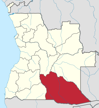
Cunene is a province of Angola. It has an area of 87,342 km2 and a population of 990,087 in 2014.
Huíla is a province of Angola. It has an area of 79,023 square kilometres (30,511 sq mi) and a population of 2,497,422. Lubango is the capital of the province. Basket-making is a significant industry in the province; many make baskets out of reeds.

The Cunene or Kunene is a river in Southern Africa. It flows from the Angola highlands southwards to the border with Namibia. It then flows in a westerly direction along the border until it reaches the Atlantic Ocean. It is one of the few perennial rivers in the region. It is about 1,050 kilometres (652 mi) long, with a drainage basin 106,560 square kilometres (41,143 sq mi) in area. Its mean annual discharge is 174 m3/s at its mouth. The Epupa Falls lie on the river. Olushandja Dam dams a tributary of the river, the Etaka, and helps to provide the Ruacana Power Station with water.
Cahama is a town, with a population of 12,767, and a municipality of Cunene Province, Angola. The population of the municipality was 70,061 according to the 2014 census in an area of 9,700 km2. The municipality consists of the communes Cahama and Otchinjau. There is an airport (FN17) to the north of the town.
Ondjiva, formerly Vila Pereira d'Eça, is a town, with a population of 121,537 (2014), and a commune in the municipality of Cuanhama, province of Cunene, Angola. It is also the administrative capital of Cunene Province and is located at the extreme south of the country, about 42 kilometres (26 mi) from the border with Namibia. It was traditionally the seat of the Ovambo king of the Oukwanyama tribe. Ondjiva was greatly affected by the Angolan Civil War (1975-2002).

Xangongo is a town, with a population of 35,000 (2014), and a commune in the municipality of Ombadja, province of Cunene, Angola.
Cuvelai is a town and municipality in Cunene Province in Angola. The municipality had a population of 57,398 in 2014.
Namacunde or Namakunde is a town and municipality in Cunene Province in Angola. The municipality had a population of 142,047 in 2014.
Angola is divided into eighteen provinces (províncias) and 163 municipalities.
Iomerê is a municipality in the state of Santa Catarina in the South region of Brazil.
Marcelina Vahekeni is an Angolan model and beauty pageant titleholder who was crowned Miss Angola 2011 and represented her country in the 2012 Miss Universe pageant.

Humbe is a town and commune in the municipality of Ombadja, province of Cunene, Angola.
Cuanhama, also known as Kwanhama, is a municipality in Cunene Province, Angola. Cuanhama occupies 20,255 square kilometers and has 374,529 inhabitants as of the 2014 census. It is bordered to the north by the municipality of Cuvelai, east by the municipality of Menongue, the south by the municipality of Namacunde, and west by the municipality of Ombadja. Ondjiva, the administrative capital of Cunene Province, is located in Cuanhama. Other communes in Cuanhama include Môngua, Evale, Nehone and Tchimporo-Yonde.
Ombadja is municipality in Cunene Province, Angola. Its seat is the village of Xangongo. It occupies 12,264 square kilometers and has about 304,964 inhabitants as of the 2014 Angolan census. It is bordered to the north by the municipality of Matala, in the east by the municipalities of Cuvelai, Namacunde, Cuanhama, west by the municipalities of Curoca and Cahama. It contains the communes of Xangongo, Ombala-Yo-Mungo, Naulila, Humbe and Mucope.
Chitado is a town and commune of Angola, located in the province of Cunene.
Ombala yo Mungu is a town and commune of Angola, located in the province of Cunene.
Augusto e Kafelango Comercial FC best known as AKC is an Angolan sports club from the city of Ondjiva, Cunene province.