Luzhniki Metro Bridge

Last updated
The Luzhniki bridge Luzhniki Metro Bridge 02.jpg
The Luzhniki bridge
The upper level KosyginaStreet Moscow view to Khamovniki 06-2015 img2.jpg
The upper level

Luzhniki Metro Bridge (Russian : Лужнецкий метромост), also known as Metromost (Метромост), is a concrete double-decked (two-level) arch bridge carrying a road and a Moscow Metro line across the Moskva River in Moscow, Russia. It connects the neighbourhood of Luzhniki Stadium to Sparrow Hills. The bridge houses Vorobyovy Gory, the only station of Moscow Metro located over water. Designed in 1958 by V.G. Andreyev and N.N. Rudomasin (structural engineering), the bridge rapidly decayed and was rebuilt in 1997–2002.

Russian language East Slavic language

Russian is an East Slavic language, which is official in the Russian Federation, Belarus, Kazakhstan and Kyrgyzstan, as well as being widely used throughout Eastern Europe, the Baltic states, the Caucasus and Central Asia. It was the de facto language of the Soviet Union until its dissolution on 25 December 1991. Although nearly three decades have passed since the breakup of the Soviet Union, Russian is used in official capacity or in public life in all the post-Soviet nation-states, as well as in Israel and Mongolia.

Arch bridge bridge with abutments at each end shaped as a curved arch

An arch bridge is a bridge with abutments at each end shaped as a curved arch. Arch bridges work by transferring the weight of the bridge and its loads partially into a horizontal thrust restrained by the abutments at either side. A viaduct may be made from a series of arches, although other more economical structures are typically used today.

Moscow Metro rapid transit system in Moscow

The Moscow Metro is a rapid transit system serving Moscow, Russia and the neighbouring Moscow Oblast cities of Krasnogorsk, Reutov, Lyubertsy and Kotelniki. Opened in 1935 with one 11-kilometre (6.8 mi) line and 13 stations, it was the first underground railway system in the Soviet Union. As of 2018, the Moscow Metro excluding the Moscow Central Circle and Moscow Monorail has 224 stations and its route length is 381 km (237 mi), making it the fifth longest in the world. The system is mostly underground, with the deepest section 84 metres (276 ft) underground at the Park Pobedy station, one of the world's deepest. It's the busiest metro system in Europe, and a tourist attraction in itself.

Contents

Metro Bridge (1958)

The bridge was officially opened January 12, 1959. Total length with ramps 1,179 meters, arch spans 45 - 108 – 45 meters. The upper deck, 25.8 meters wide, carried 6 lanes of traffic, the lower deck housed Vorobyovy Gory metro station. The bridge was completed in 19 months. [1] The bridge builders used salt to speed up concrete hydration; in 1959, it was commissioned with incomplete moisture protection. [2] This caused rapid corrosion of rebars and tension cables.

Vorobyovy Gory (Moscow Metro) Moscow Metro station

Vorobyovy Gory is a Moscow Metro station. It is on the Sokolnicheskaya Line, between Universitet and Sportivnaya stations. Its name originates from a nearby elevated area literally translated as Sparrow Hills.

Mineral hydration is an inorganic chemical reaction where water is added to the crystal structure of a mineral, usually creating a new mineral, usually called a hydrate.

Corrosion Gradual destruction of materials by chemical reaction with its environment

Corrosion is a natural process, which converts a refined metal to a more chemically-stable form, such as its oxide, hydroxide, or sulfide. It is the gradual destruction of materials by chemical and/or electrochemical reaction with their environment. Corrosion engineering is the field dedicated to controlling and stopping corrosion.

Decay (1958–1997)

On July 8, 1959, rain water broke through the station hall roofing and flooded the tracks. In the following years, aluminium and steel parts of the station hall started falling apart, hiding far worse corrosion processes inside the concrete structure. As early as 1963, examinations signalled imminent danger. [2] By 1983, the bridge had lost 60% of its structural load capacity. In 1983, the station was closed, in 1986-87 the subway tracks diverted to temporary steel box girder bridges (29 meters left and 29 meters right from the main bridge axis).

Box girder bridge type of bridge

A box girder bridge is a bridge in which the main beams comprise girders in the shape of a hollow box. The box girder normally comprises either prestressed concrete, structural steel, or a composite of steel and reinforced concrete. The box is typically rectangular or trapezoidal in cross-section. Box girder bridges are commonly used for highway flyovers and for modern elevated structures of light rail transport. Although normally the box girder bridge is a form of beam bridge, box girders may also be used on cable-stayed bridges and other forms.

Reconstruction (1997–2002)

Reconstruction began with the demolition of the station hall, opening access to the main arches. The inner arches remained standing; their concrete bowstring was replaced with a steel tie. Once the arch was reinforced, in 1999, the builders demolished the automobile road deck and the columns that carried it. The new concrete deck was commissioned for automobile traffic in 2000. In July–August 2001, subway traffic returned to the main bridge tracks, the temporary bridges were removed; the restored subway station reopened on December 14, 2002. [3]

See also

Related Research Articles

Paveletskaya (Zamoskvoretskaya line) Moscow Metro station

Paveletskaya is a Moscow Metro station on the Zamoskvoretskaya line, located in the Zamoskvorechye District, Central Administrative Okrug. It was opened in 1943 and was designed by S.V. Lyashchenko and E.S. Demchenko. Paveletskaya features tall white marble pillars decorated with the hammer and sickle and a high, arched ceiling. The walls are faced with white marble.

Khamovniki District is a district of Central Administrative Okrug of the federal city of Moscow, Russia. Population: 102,730 (2010 Census); 97,110 (2002 Census).

Sparrow Hills hills in Moscow

Sparrow Hills, formerly known as Lenin Hills between 1935 and 1999, is a hill on the right bank of the Moskva River and one of the highest points in Moscow, reaching a height of 80 m (260 ft) above the river level.

Bolshoy Kamenny Bridge deck arch bridge

Bolshoy Kamenny Bridge is a steel arch bridge spanning Moskva River at the western end of the Moscow Kremlin. Its predecessor was the first permanent stone bridge in Moscow, Russia. The existing bridge was completed in 1938 by engineer Nikolai Kalmykov.

Andreyevsky Bridge

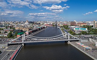
Andreyevsky Bridge name refers to a historical bridge demolished in 1998 and three existing bridges across Moskva River, located between Luzhniki and Gorky Park in Moscow.

The name Krasnoluzhsky Bridge refers to three existing bridges across Moskva River, located between Kievsky Rail Terminal and Luzhniki in Moscow.

Smolensky Metro Bridge is a steel arch bridge that spans Moskva River in Dorogomilovo District of Moscow, Russia. It is the first bridge built for the Moscow Metro in 1935–1937, designed by N.P.Polikarpov, P.K.Antonov and Yakovlev brothers. It is one of two bridges over Moskva River that are used exclusively by Metro (subway) trains, while the other Metro bridges combine road and rail.

Bolshoy Ustinsky Bridge is a steel arch bridge that spans Moskva River near the mouth of Yauza River, connecting the Boulevard Ring with Zamoskvorechye district in Moscow, Russia. It was completed in May 1938 by V.M.Vakhurkin, G.P.Golts and D.M.Sobolev.

Novospassky Bridge is a steel plate girder bridge that spans Moskva River, connecting Novospassky Monastery and Paveletsky rail terminal areas in Moscow, Russia. It was built in 1911, as a triple-span steel arch bridge. Reconstruction in 2000 replaced arches with a simpler plate girder structure. Note that the memorial plaque on the bridge spells its name Ново-Спасский, with dash, despite tradition and spelling rules.

Moscow-Riga Railroad Bridge is a concrete arch bridge that spans Moscow Canal between Tushino and Shchukino Districts in northwestern Moscow, Russia. The bridge does not have an official name and is sometimes styled as Railroad bridge over Moscow Canal. It was completed in 1936, designed by A.S.Bachelis.

Bolshoy Krasnokholmsky Bridge

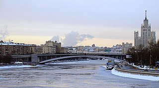
Bolshoy Krasnokholmsky Bridge is a steel arch bridge that spans Moskva River in downtown Moscow, Russia, carrying Garden Ring between Tagansky District and Zamoskvorechye Districts. It was completed in 1938 by V.M.Vakhurkin, G.P.Golts and D.M.Sobolev. Its main span is the widest arch span in Moscow.

Krymsky Bridge

Krymsky Bridge or Crimean Bridge is a steel suspension bridge in Moscow. The bridge spans the Moskva River 1,800 metres south-west from the Kremlin and carries the Garden Ring across the river. The bridge links the Crimean Square to the north with Krymsky Val street to the south. The nearby Moscow Metro stations are Park Kultury and Oktyabrskaya.

Bolshoy Moskvoretsky Bridge

Bolshoy Moskvoretsky Bridge is a concrete arch bridge that spans the Moskva River in Moscow, Russia, immediately east of the Moscow Kremlin. The bridge connects Red Square with Bolshaya Ordynka street in Zamoskvorechye. Built in 1936-1937, it was designed by V. S. Kirillov and Alexey Shchusev.

Saburovsky Rail Bridges

Saburovsky Rail Bridges are two adjacent steel bridges that span Moskva River in southern Moskvorechye-Saburovo District of Moscow, Russia. They were completed in 1924 and 1953, when Saburovo was a remote suburb of Moscow.

Borodinsky Bridge

Borodinsky Bridge is a steel plate girder bridge that spans Moskva River, connecting Dorogomilovo District and Kievsky Rail Terminal with the centre of Moscow, Russia. The bridge was built in 1911–1912 as deck arch bridge by N.I. Oskolkov, M.I. Schekotov and Roman Klein. In 2001, the bridge was reconstructed, replacing arches and deck with a plate girder structure.

Sadovnichesky Bridge

Sadovnichesky Bridge is a cоncrete pedestrian arch bridge that spans Vodootvodny Canal in historical Zamoskvorechye district of Moscow, Russia. The bridge connects Balchug island with Zamoskvorechye mainland. It was built in 1963, designed by Nina Bragina, V.A. Korchagin and K.P. Savelyev. It is Moscow's nearest adaptation of a Moon bridge.

Schluzovoy Bridge

Schluzovoy Bridge is a concrete cantilever bridge in Moscow, Russia, spanning the eastern extremity of Vodootvodny Canal and connecting right-bank embankments of Moskva River. Existing bridge was completed in 1965 by engineer Z.V. Freydina.

Preobrazhensky Metro Bridge bridge in Russia

Preobrazhenskiy Metro Bridge is the shortest of four rail bridges in Moscow, Russia. It is located in the Eastern Administrative Okrug of the city. It spans over Yauza River and is a part of the Sokolnicheskaya Line of Moscow Metro. It connects the stations Preobrazhenskaya Ploshchad and Sokolniki.

The Luzhniki Olympic Complex is one of the biggest multifunctional sports complexes of the world, built between 1955 and 1956, located in Moscow, Russia. Formerly known as the Central Lenin Stadium, it served as the Olympic Park of the 1980 Summer Olympics.

References

  1. Russian: Носарев В.А., Скрябина, Т.А., "Мосты Москвы", М, "Вече", 2004, стр. 153 (Bridges of Moscow, 2004, p.153) ISBN   5-9533-0183-9; other sources name 15 months. The authors of Bridges of Moscow, then college students, worked at the construction site as trainees, 1957-1958.
  2. 1 2 Bridges of Moscow, 2004, p.155
  3. metro.molot.ru

Coordinates: 55°42′37.0″N37°33′33.6″E / 55.710278°N 37.559333°E / 55.710278; 37.559333

Geographic coordinate system Coordinate system

A geographic coordinate system is a coordinate system that enables every location on Earth to be specified by a set of numbers, letters or symbols. The coordinates are often chosen such that one of the numbers represents a vertical position and two or three of the numbers represent a horizontal position; alternatively, a geographic position may be expressed in a combined three-dimensional Cartesian vector. A common choice of coordinates is latitude, longitude and elevation. To specify a location on a plane requires a map projection.