
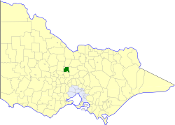
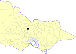
Lyal is a rural locality in the City of Greater Bendigo, [2] in the Australian state of Victoria.
Lyal is a rural locality in the City of Greater Bendigo, [2] in the Australian state of Victoria.
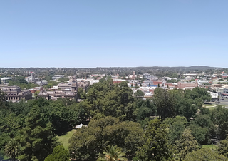
Bendigo is a city in Victoria, Australia, located in the Bendigo Valley near the geographical centre of the state and approximately 150 kilometres (93 mi) north-west of Melbourne, the state capital.

The City of Greater Bendigo is a local government area in Victoria, Australia, located in the central part of the state. It covers an area of 3,000 square kilometres (1,200 sq mi) and, in June 2021, had a population of 123,632. It includes the city of Bendigo and the towns of Axedale, Elmore, Heathcote, Marong, Raywood and Strathfieldsaye. It was formed in 1994 from the amalgamation of the former City of Bendigo with the Borough of Eaglehawk, Shire of Strathfieldsaye, Shire of Huntly, Rural City of Marong and parts of the Shire of McIvor. It is the state’s third largest economy base and is considered a service and infrastructure centre for north central Victoria. The city is surrounded by 40,000 hectares of regional, state and national parkland.
Bendigo and Adelaide Bank is an Australian financial institution, operating primarily in retail banking. The company was formed by the merger of Bendigo Bank and Adelaide Bank in November 2007.

The Division of Bendigo is an Australian electoral division in the state of Victoria. The division was proclaimed in 1900, and was one of the original 65 divisions to be contested at the first federal election. It is named for the city of Bendigo.
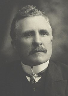
Sir John QuickLL.D. was an Australian lawyer, politician and judge. He played a prominent role in the movement for Federation and the drafting of the Australian constitution, later writing several works on Australian constitutional law. He began his political career in the Victorian Legislative Assembly (1880–1889) and later won election to the House of Representatives at the first federal election in 1901. He served as Postmaster-General in the third Deakin Government (1909–1910). He lost his seat in 1913 and ended his public service as deputy president of the Commonwealth Court of Conciliation and Arbitration (1922–1930).
Bendigo Airport, is located in East Bendigo just north of Bendigo, Victoria, Australia, just off the Midland Highway. The airport is located approximately 10 minutes away from the Bendigo CBD.

The Bendigo Advertiser is the daily (Monday–Saturday) newspaper for Bendigo, Victoria and its surrounding region. The Bendigo Advertiser is published by Australian Community Media with a circulation between 5000 and 7000 depending on the day of publication.
The Anglican Diocese of Bendigo is a diocese of the Anglican Church of Australia. It is situated in the Bendigo region of the state of Victoria, Australia. Its geographic remit extends from that part of Victoria that lies north of the Great Dividing Range and west of the Goulburn River to the border with the state of South Australia. The diocesan cathedral is St Paul's Cathedral, Bendigo. The diocese was separated from the Diocese of Melbourne in 1902, with Henry Archdall Langley installed as the first bishop. The current bishop, Matt Brain, was installed on 17 February 2018.

Bendigo East is an electoral district of the Legislative Assembly in the Australian state of Victoria. It covers an area of 2,711 square kilometres (1,047 sq mi) covering the part of the city of Bendigo east of the Yungera railway line and surrounding rural areas to the north, east and south. It includes the Bendigo suburbs of East Bendigo, Epsom, Flora Hill, Junortoun, Kennington, Quarry Hill, Spring Gully, Strathdale, Strathfieldsaye and White Hills, and the surrounding towns of Axedale, Goornong, Huntly, Mandurang, Raywood and Sedgwick. It also includes parts of the localities of Eaglehawk, Elmore, Golden Square and Ravenswood, and the Bendigo campus of La Trobe University. It lies within the Northern Victoria Region of the upper house, the Legislative Council.

Bendigo West is an electoral district of the Legislative Assembly in the Australian state of Victoria. It is a 1,524 square kilometres (588 sq mi) electorate centred on the city of Bendigo west of the Yungera railway line, and including surrounding rural towns to the west and south-west. It encompasses the localities of Bendigo City, California Gully, Castlemaine, Harcourt, Long Gully, Maldon, Marong, Newstead and West Bendigo. It also includes parts of the Bendigo suburbs of Eaglehawk, Golden Square and Kangaroo Flat. It lies within the Northern Victoria Region of the upper house, the Legislative Council.
The Shire of Strathfieldsaye was a local government area immediately to the east and southeast of the regional city of Bendigo, Victoria, Australia, and included the eastern suburbs of Bendigo's metropolitan area. The shire covered an area of 601.34 square kilometres (232.2 sq mi), and existed from 1861 until 1994.
The City of Bendigo was a local government area covering the central area and inner western suburbs of the regional city of Bendigo, Victoria, Australia. The city covered an area of 32.53 square kilometres (12.6 sq mi) and existed from 1855 to 1994.
The Borough of Eaglehawk was a local government area which covered the northwestern suburbs of the regional city of Bendigo, Victoria, Australia. The borough covered an area of 14.54 square kilometres (5.6 sq mi), and existed from 1862 until 1994.
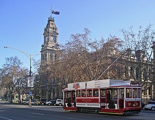
Trams in Bendigo have operated since 1890. They ceased to operate as a means of public transport in 1972 but part of the main network continues to operate today as a tourist attraction. Limited trials have also been made in 2009 with operating commuter service, but with minimal usage by the public.

During the Australian gold rushes, starting in 1851, significant numbers of workers moved from elsewhere in Australia and overseas to where gold had been discovered. Gold had been found several times before, but the colonial government of New South Wales had suppressed the news out of the fear that it would reduce the workforce and so destabilise the economy.
The electoral district of Bendigo was an electorate of the Victorian Legislative Assembly in the Australian state of Victoria. Centred on the city of Bendigo, the district was formed when the electorates of Bendigo East and Bendigo West were merged into a single district in 1927. Bendigo was abolished in 1985 when it was once again split into separate East and West districts.
Sandhurst South was an electoral district of the Legislative Assembly in the Australian state of Victoria from 1889 to 1904. It was based on an area south of the town of Sandhurst south-east of High street and the south west of Russell-street, Strathfieldsaye shire and most of Marong shire.

North Bendigo is a suburb of the city of Bendigo in central Victoria, Australia. North Bendigo is in the City of Greater Bendigo, 2.4 kilometres (1.5 mi) north of the Bendigo central business district. At the 2011 census, North Bendigo had a population of 3,953.
Huntly is a town in northern Bendigo, Victoria, Australia in the City of Greater Bendigo local government area, 169 kilometres north of the state capital, Melbourne. At the 2016 census, Huntly had a population of 2,379.
The Bendigo V/Line rail service is a regional passenger rail service operated by V/Line in Victoria, Australia. It serves passengers between state capital Melbourne, Victoria and the regional city of Bendigo, Victoria.
| | This article about a location in Victoria, Australia is a stub. You can help Wikipedia by expanding it. |