M'Naguer

Last updated
M'Naguer
اﻟﻤﻨﻘﺮ
Commune and town
DZ 30 Mnaguer.svg
Algeria location map.svg
Red pog.svg
M'Naguer
Coordinates: 33°7′35″N6°21′07″E / 33.12639°N 6.35194°E / 33.12639; 6.35194 Coordinates: 33°7′35″N6°21′07″E / 33.12639°N 6.35194°E / 33.12639; 6.35194
CountryFlag of Algeria.svg  Algeria
Province Touggourt Province
District Taibet District
Established [1] 1984
Area
[1]
  Total8,892 km2 (3,433 sq mi)
Elevation
98 m (322 ft)
Population
 (2008) [2]
  Total14,179
  Density1.6/km2 (4.1/sq mi)
Time zone UTC+1 (CET)

M'Naguer (also written M'Nagueur) is a town and commune in Taibet District, Touggourt Province, Algeria. According to the 2008 census it has a population of 14,179, [2] up from 11,243 in 1998, [3] and an annual population growth rate of 2.4%. [2]

Contents

Geography

M'Naguer lies at an elevation of 98 metres (322 ft) surrounded by palm groves, forming one of many scattered oases lying between Touggourt and El Oued. Beyond the oasis are the sand dunes of the Grand Erg Oriental desert.

Climate

Like most towns in Saharan Africa, M'Naguer has a hot desert climate, with very hot summers and mild winters, and very little precipitation throughout the year.

Economy

Agriculture is the primary economic activity of M'Naguer, accounting for 63% of the economy. Palm farming is the most significant crop, although other fruits and vegetables are grown, along with the rearing of livestock such as sheep, goats, camels and cattle. [1]

The economy of M'Naguer also benefits from tourism; the oasis, the diversity of plants and animals, and architectural sites are important attractions. Traditional industries such as pottery, weaving and knitting are also significant. [1]

Transportation

M'Naguer lies on the N16 national highway between Touggourt 35 kilometres (22 mi) to the west and El Oued 60 kilometres (37 mi) to the northeast. The district capital Taibet is 6 kilometres (4 mi) to the south via a local road, and the town of Benaceur is located on the N16 5 kilometres (3 mi) to the east. The town is 190 kilometres (120 mi) distant from the provincial capital Ouargla. [1]

The municipality of M'Naguer has an estimated 119 kilometres (74 mi) of local roads. [1]

Education

2.8% of the population has a tertiary education (the second lowest in the province), and another 11.8% has completed secondary education. [4] The overall literacy rate is 66.1%, and is 75.3% among males (the second lowest in the province) and 56.3% among females. [5]

Localities

The commune is composed of 16 localities: [6]

Related Research Articles

<span class="mw-page-title-main">El Oued</span> City in El Oued Province, Algeria

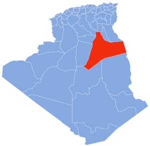
El Oued, Souf or Oued Souf is a city, and the capital of El Oued Province, in Algeria. The oasis town is watered by an underground river, hence its name is El Oued which enables date palm cultivation and the rare use of brick construction for housing. As most roofs are domed, it is known as the "City of a Thousand Domes".

<span class="mw-page-title-main">Illizi</span> City in Illizi Province, Algeria

Illizi is a town and commune, coextensive with Illizi District, situated in the south-eastern part of Algeria, and capital of Illizi Province. According to the 2008 census it is the largest commune by population in the province, with a population of 17,252, up from 10,163 in 1998, and an annual population growth rate of 5.5%, the highest in the province. It is one of the gates to the Tassili N'Ajjer National Park with caves situated under the sands containing prehistoric drawings dating from 6000 years BC. There is a hotel and two camping sites, as well as many local tourist agencies.

<span class="mw-page-title-main">N'Goussa</span> Commune and town in Ouargla Province, Algeria

N'Goussa is a town and commune, coextensive with the district of the same name, in Ouargla Province, Algeria. Some of its inhabitants speak the Ouargli language. As of 2008, the population of the town was 19,039, up from 13,344 in 1998, with an annual population growth rate of 2.2%. The town is on a local road, about 20 kilometres (12 mi) north of Ouargla on the way to El Hadjira further north.

<span class="mw-page-title-main">Debila</span> Commune and town in El Oued Province, Algeria

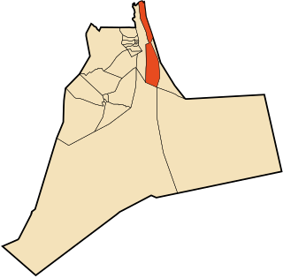
Debila is a town and commune, and the capital of Debila District, in El Oued Province, Algeria. According to the 2008 census it has a population of 25,158, up from 20,088 in 1998, and an annual growth rate of 2.3%.

<span class="mw-page-title-main">Djamaa</span> Commune and town in El Oued Province, Algeria

Djamaa is a town and commune in El Oued Province, Algeria. According to the 2008 census it has a population of 50,916, up from 37,438 in 1998, with an annual growth rate of 3.1%.

<span class="mw-page-title-main">Hassani Abdelkrim</span> Place in El Oued Province, Algeria

Hassani Abdelkrim is a town and commune in Debila District, El Oued Province, Algeria. According to the 2008 census it has a population of 22,755, up from 17,207 in 1998, with a population growth rate of 2.9%.

<span class="mw-page-title-main">Hassi Khelifa</span> Commune and town in El Oued Province, Algeria

Hassi Khelifa is a town and commune, and capital of Hassi Khelifa District in El Oued Province, Algeria. According to the 2008 census it has a population of 31,784, up from 25,118 in 1998, with an annual growth rate of 2.4%.

<span class="mw-page-title-main">Oum Touyour</span> Commune and town in El Oued Province, Algeria

Oum Touyour is a town and commune in El M'Ghair District, El Oued Province, Algeria. According to the 2008 census it has a population of 11,069, up from 9,735 in 1998, with an annual growth rate of 1.3%, the lowest in the province.

<span class="mw-page-title-main">Sidi Amrane</span> Commune and town in El Oued Province, Algeria

Sidi Amrane is a town and commune in Djamaa District, El Oued Province, Algeria, 5 kilometres (3.1 mi) south of Djamaa. According to the 2008 census it has a population of 21,772, up from 18,732 in 1998, and an annual growth rate of 1.5%.

<span class="mw-page-title-main">Sidi Khellil</span> Commune and town in El Oued Province, Algeria

Sidi Khellil is a town and commune in El M'Ghair District, El Oued Province, Algeria. According to the 2008 census it has a population of 6,547, up from 5,524 in 1998, and an annual growth rate of 1.7%.

<span class="mw-page-title-main">Taleb Larbi</span> Commune and town in El Oued Province, Algeria

Taleb Larbi is a town and commune, and capital of Taleb Larbi District, El Oued Province, Algeria. According to the 2008 census it has a population of 7,074, up from 3,582 in 1998, with an annual of growth rate of 7.2% per year, the second highest in the province.

<span class="mw-page-title-main">Tendla</span> Commune and town in El Oued Province, Algeria

Tendla is a town and commune in Djamaa District, El Oued Province, Algeria. According to the 2008 census it has a population of 9,193, up from 8,033 in 1998, with an annual growth rate of 1.4%, the second-lowest in the province.

El Guerrara Commune and town in Ghardaïa Province, Algeria

El Guerrara is a town and commune, coextensive with El Guerrara District, in Ghardaïa Province, Algeria. According to the 2008 census it has a population of 59,514, up from 48,313 in 1998, with an annual growth rate of 2.1%.

<span class="mw-page-title-main">Aïn Beida, Ouargla</span> Commune and town in Ouargla Province, Algeria

Ain Beida is a town and commune in Sidi Khouïled District, Ouargla Province, Algeria. According to the 2008 census it has a population of 19,039, up from 14,500 in 1998, and an annual population growth rate of 2.8%. Ain Beida is just 6 kilometres (3.7 mi) from central Ouargla and is effectively a suburb of the city. It is also home to the Ain Beida Airport, Ouargla's principal airport.

<span class="mw-page-title-main">Balidat Ameur</span> Commune and town in Touggourt Province, Algeria

Balidat Ameur is a town and commune in Touggourt Province, Algeria, located near the provincial capital of Ouargla. According to the 2008 census it has a population of 14,540, up from 12,135 in 1998, and a population growth rate of 1.9%. The commune is made of two areas, the main town of Balidat Ameur, and the village of Goug 7 kilometres (4.3 mi) to the southeast.

<span class="mw-page-title-main">Megarine</span> Commune and town in Touggourt Province, Algeria

Megarine is a town and commune in Touggourt Province, Algeria, located just north of the city of Touggourt. According to the 2008 census it has a population of 13,751, up from 10,996 in 1998, and an annual growth rate of 2.3%.

<span class="mw-page-title-main">Sidi Slimane, Ouargla</span> Commune and town in Touggourt Province, Algeria

Sidi Slimane is a town and commune in Mégarine District, Touggourt Province, Algeria, located near the city of Touggourt. According to the 2008 census it has a population of 8,072, up from 6,822 in 1998, and an annual growth rate of 1.7%.

<span class="mw-page-title-main">Taibet</span> Commune and town in Touggourt Province, Algeria

Taibet is a town and commune, and the capital of Taibet District, in Touggourt Province, Algeria. According to the 2008 census it has a population of 20,174, up from 14,322 in 1998, and a growth rate of 3.6%.

<span class="mw-page-title-main">Tamacine</span> Commune and town in Touggourt Province, Algeria

Tamacine is a town and commune, and capital of Témacine District, in Touggourt Province, Algeria. According to the 2008 census it has a population of 20,067, up from 15,933 in 1998, and an annual growth rate of 2.4%. It is around 10 kilometres (6.2 mi) south of Touggourt. The Tugurt language is spoken by some residents of Tamacine.

Oum Zebed is a village in the commune of M'Naguer, in Taibet District, Ouargla Province, Algeria. The village is located 5 kilometres (3.1 mi) northwest of M'Naguer and 27 kilometres (17 mi) east of Touggourt.

References

  1. 1 2 3 4 5 6 "Official website of the province of Ouargla - M'Naguer" (in Arabic). Archived from the original on 24 March 2013. Retrieved 6 March 2013.
  2. 1 2 3 "Population: Ouargla Wilaya" (PDF) (in French). Office National des Statistiques Algérie. Archived from the original (PDF) on 13 May 2013. Retrieved 24 February 2013.
  3. Statoids
  4. "Structure relative de la population résidente des ménages ordinaires et collectifs âgée de 6 ans et plus selon le niveau d'instruction et la commune de résidence" (PDF) (in French). Office National des Statistiques Algérie. Archived from the original (PDF) on 16 May 2013. Retrieved 13 February 2013.
  5. "Taux d'analphabétisme et taux d'alphabétisation de la population âgée de 15 ans et plus, selon le sexe et la commune de résidence " (PDF) (in French). Office National des Statistiques Algérie. Archived from the original (PDF) on 16 May 2013. Retrieved 13 February 2013.
  6. "Décret n° 84-365, fixant la composition, la consistance et les limites territoriale des communes. Wilaya d'El Oued" (PDF) (in French). Journal officiel de la République Algérienne. 19 December 1984. p. 1551. Archived from the original (PDF) on 21 October 2013. Retrieved 2 March 2013.
Neighbouring towns and cities