Gmina Krasne is a rural gmina in Przasnysz County, Masovian Voivodeship, in east-central Poland. Its seat is the village of Krasne, which lies approximately 13 kilometres (8 mi) south-east of Przasnysz and 79 km (49 mi) north of Warsaw.

Kolonia Fryderyk is a village in Gmina Gorzyce, Wodzisław County, Silesian Voivodeship, Poland. It has a population of 1,105 (2006). It lies approximately 2 kilometres (1 mi) north-east of Gorzyce, 5 km (3 mi) south-west of Wodzisław Śląski, and 52 km (32 mi) south-west of the regional capital Katowice.
Kojrany is a settlement in the administrative district of Gmina Juchnowiec Kościelny, within Białystok County, Podlaskie Voivodeship, in north-eastern Poland.
Kowalowy Gród is a village in the administrative district of Gmina Michałowo, within Białystok County, Podlaskie Voivodeship, in north-eastern Poland, close to the border with Belarus.
Koszele is a village in the administrative district of Gmina Orla, within Bielsk County, Podlaskie Voivodeship, in north-eastern Poland. It lies approximately 12 kilometres (7 mi) south-east of Bielsk Podlaski and 48 km (30 mi) south of the regional capital Białystok.
Jadowniki is a village in the administrative district of Gmina Brzesko, within Brzesko County, Lesser Poland Voivodeship, in southern Poland. It lies approximately 3 kilometres (2 mi) east of Brzesko and 52 km (32 mi) east of the regional capital Kraków.
Niemojki-Stacja is a village in the administrative district of Gmina Łosice, within Łosice County, Masovian Voivodeship, in east-central Poland. It lies approximately 5 kilometres (3 mi) north of Łosice and 116 km (72 mi) east of Warsaw.
Modzele-Bartłomieje is a village in the administrative district of Gmina Nowe Miasto, within Płońsk County, Masovian Voivodeship, in east-central Poland.
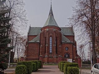
Krasne is a village in Przasnysz County, Masovian Voivodeship, in east-central Poland. It is the seat of the gmina called Gmina Krasne. It lies approximately 13 kilometres (8 mi) south-east of Przasnysz and 79 km (49 mi) north of Warsaw.
Czapliniec is a village in the administrative district of Gmina Sieraków, within Międzychód County, Greater Poland Voivodeship, in west-central Poland.
Bronisławki is a village in the administrative district of Gmina Ujście, within Piła County, Greater Poland Voivodeship, in west-central Poland. It lies approximately 12 kilometres (7 mi) south of Ujście, 21 km (13 mi) south of Piła, and 65 km (40 mi) north of the regional capital Poznań.
Chojno is a village in the administrative district of Gmina Wronki, within Szamotuły County, Greater Poland Voivodeship, in west-central Poland. It lies approximately 12 kilometres (7 mi) west of Wronki, 28 km (17 mi) north-west of Szamotuły, and 59 km (37 mi) north-west of the regional capital Poznań.
Chociszewo is a village in the administrative district of Gmina Skoki, within Wągrowiec County, Greater Poland Voivodeship, in west-central Poland.
Osiedle Poznańskie is a village in the administrative district of Gmina Deszczno, within Gorzów County, Lubusz Voivodeship, in western Poland. It lies approximately 4 kilometres (2 mi) north of Deszczno and 7 km (4 mi) south-east of Gorzów Wielkopolski.

Pustkowo is a village in the administrative district of Gmina Rewal, within Gryfice County, West Pomeranian Voivodeship, in north-western Poland. It lies approximately 4 kilometres (2 mi) south-west of Rewal, 23 km (14 mi) north-west of Gryfice, and 77 km (48 mi) north of the regional capital Szczecin.
Cychry is a village in the administrative district of Gmina Dębno, within Myślibórz County, West Pomeranian Voivodeship, in north-western Poland. It lies approximately 6 kilometres (4 mi) south of Dębno, 30 km (19 mi) south of Myślibórz, and 82 km (51 mi) south of the regional capital Szczecin.
Inates is a village and rural commune in Niger.
Bogojevce is a village in the municipality of Leskovac, Serbia. According to the 2002 census, the village has a population of 1571 people.
Mäebe is a village in Saaremaa Parish, Saare County in western Estonia.

Dulan is a village in the municipality of Vranje, Serbia. According to the 2002 census, the village has a population of 97 people.


