Mackinaw River

Last updated

Mackinaw River
Waltmire Bridge (Mackinaw River) from NW 1.jpg
Mackinaw River near Tremont, Illinois
Mackinaw River
Physical characteristics
Source 
  location Ford County east of Sibley, Illinois
  coordinates 40°35′20″N88°21′59″W / 40.5889233°N 88.3664421°W / 40.5889233; -88.3664421 (Mackinaw River origin)
Mouth  
  location
Confluence with the Illinois River near Mapleton, Illinois
  coordinates
40°33′06″N89°43′56″W / 40.5517055°N 89.7323284°W / 40.5517055; -89.7323284 (Mackinaw River mouth)
  elevation
443 ft (135 m)
Length130 mi (210 km)
Discharge 
  location Green Valley, Illinois
  average772 cu/ft. per sec. [1]
Basin features
ProgressionMackinaw River → Illinois → Mississippi → Gulf of Mexico
GNIS ID 403283

The Mackinaw River is a 130-mile-long (210 km) [2] tributary of the Illinois River in the U.S. state of Illinois. [3] Its watershed covers approximately 1,136 square miles (3,000 km2), [4] and contains some of the most productive agricultural land in the United States. The river itself maintains some of the highest quality streams in the state and provides habitat for 60-70 native fish species and 25-30 species of mussels. [5] Its name, also spelled Mackinac, is derived from the Ojibwe word mikinaak meaning "turtle". [6]

Contents

Description

The Mackinaw River begins near Sibley, Illinois, in Ford County. From its headwaters the river flows west through McLean County, where it provides drainage to part of the Bloomington–Normal metropolitan area, and Woodford County. It continues west and then southwestward through Tazewell County before flowing into the Illinois River just south of Pekin. [5]

The river flows through three natural divisions, including the Grand Prairie, Upper Mississippi River and Illinois Bottomlands, and Illinois and Mississippi Sand Areas. Early in its life, several thousand years ago following the Wisconsin glaciation, it cut through several moraines, which influenced the structure of the riverbed. The upper section of the watershed is marked by a series of pools and fast-flowing riffles. The character of the river downstream of the moraines is markedly different, with a relatively wide floodplain, large meanders and erosion-prone sandy banks. Its principal tributaries are Panther, Walnut and Money creeks, and the Little Mackinaw River. [4]

History

People of the Hopewell culture lived in the area 1,700 to 2,100 years ago. The Kickapoo, Potawatomi, Chippewa, and Ottawa peoples also fished, hunted and lived along the river for several centuries, through the 1830s. In 1853 a group of 200 Kickapoo still lived along the river but they were expected to move to a reservation in Missouri the next year. [7]

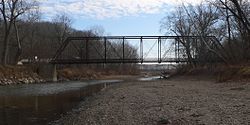
There are only a few villages along or near the Mackinaw River. These include (beginning up stream): Sibley, Colfax, Lexington, and Mackinaw. Each was laid out prior to the arrival of the railroad in the region during the 1850s, which diminished the importance of river transport.

The Mackinaw River State Fish and Wildlife Area is a 1,448-acre (586 ha) state park along the river in Tazewell County. Operated by the Illinois Department of Natural Resources, the area provides opportunities for fishing, canoeing, hiking, hunting and general interaction with nature. [8]

See also

Related Research Articles

<span class="mw-page-title-main">Illinois River</span> Illinois tributary of the Mississippi River in the United States

The Illinois River is a principal tributary of the Mississippi River at approximately 273 miles (439 km) in length. Located in the U.S. state of Illinois, the river has a drainage basin of 28,756.6 square miles (74,479 km2). The Illinois River begins with the confluence of the Des Plaines and Kankakee rivers in the Chicago metropolitan area, and it generally flows to the southwest across Illinois, until it empties into the Mississippi near Grafton, Illinois. Its drainage basin extends into southeastern Wisconsin, northwestern Indiana, and a very small area of southwestern Michigan in addition to central Illinois. Along its banks are several river ports, including the largest, Peoria, Illinois. Historic and recreation areas on the river include Starved Rock, and the internationally important wetlands of the Emiquon Complex and Dixon Waterfowl Refuge.

<span class="mw-page-title-main">Kaskaskia River</span> River in the United States

The Kaskaskia River is a tributary of the Mississippi River, approximately 325 miles (523 km) long, in central and southern Illinois in the United States. The second largest river system within Illinois, it drains a rural area of farms, as well as rolling hills along river bottoms of hardwood forests in its lower reaches. The lower reaches of the river have been canalized to allow barge traffic. In 1819, Vandalia up the river in the interior of the then new state of Illinois was chosen as its capital, which it served as until 1839.

<span class="mw-page-title-main">Sangamon River</span> River in the United States

The Sangamon River is a principal tributary of the Illinois River, approximately 246 miles (396 km) long, in central Illinois in the United States. It drains a mostly rural agricultural area and runs through Decatur and past Springfield. The river is associated with the early career of Abraham Lincoln, who was a sometime boatman working on the river, and played an important role in early European settlement of Illinois, when the area around was known as the "Sangamon River Country". The section of the Sangamon River that flows through Robert Allerton Park near Monticello was named a National Natural Landmark in 1971.

<span class="mw-page-title-main">Vermilion River (Wabash River tributary)</span> River in the United States

The Vermilion River is a tributary of the Wabash River in the states of Illinois and Indiana, United States.

<span class="mw-page-title-main">Des Plaines River</span> Tributary of the Illinois River

The Des Plaines River is a river that flows southward for 133 miles (214 km) through southern Wisconsin and northern Illinois in the United States Midwest, eventually meeting the Kankakee River west of Channahon to form the Illinois River, a tributary of the Mississippi River.

<span class="mw-page-title-main">Embarras River (Illinois)</span> River in Illinois, United States

The Embarras River is a 195-mile-long (314 km) tributary of the Wabash River in southeastern Illinois in the United States. The waters of the Embarras reach the Gulf of Mexico via the Wabash, Ohio, and Mississippi Rivers. The river drains a watershed around 1,566,450 acres (6,339.2 km2) in an agricultural region. It arises near Champaign-Urbana and flows south to near Vincennes, Indiana. The name comes from French explorers, who used the French word, embarras, for river navigation obstacles, blockages, and difficulties relating to logjams.

<span class="mw-page-title-main">Boneyard Creek</span> Creek in Illinois, U.S.

Boneyard Creek is a 3.3-mile-long (5.3 km) waterway that drains much of the cities of Champaign and Urbana, Illinois, United States. It is a tributary of the Saline Branch of the Salt Fork Vermilion River, which is a tributary of the south-flowing Vermilion River and the Wabash River. The creek flows through the northern sections of the campus of the University of Illinois Urbana-Champaign. The newsletter of the university's ACM chapter is Banks of the Boneyard, named after the creek.

<span class="mw-page-title-main">Vermilion River (Illinois River tributary)</span> River

The Vermilion River is a 74.8-mile-long (120.4 km) tributary of the Illinois River in the state of Illinois, United States. The river flows north, in contrast to a second Vermilion River in Illinois, which flows south to the Wabash River. The Illinois and Wabash rivers each have a tributary named the Little Vermilion River as well.

<span class="mw-page-title-main">Middle Fork Vermilion River</span> River in Illinois, United States

The Middle Fork of the Vermilion River is a tributary of the Vermilion River in Illinois. The Middle Fork rises in Ford County and flows southeast to join the Vermilion near Danville.

<span class="mw-page-title-main">Salt Fork Vermilion River</span> River

The Salt Fork is a tributary of the Vermilion River located in the Central Corn Belt Plains of Illinois.

<span class="mw-page-title-main">West Okaw River</span> River

The West Okaw River is a tributary of the Kaskaskia River, which it joins in Moultrie County, Illinois. The West Okaw forms an arm of Lake Shelbyville where the natural rivers used to meet.

Salt Creek is a major tributary to the Sangamon River, which it joins at the boundary between Mason and Menard County, Illinois. There are at least two other Salt Creeks in Illinois, Salt Creek, and in Effingham County, Illinois.

The Little Mackinaw River is an 18.5-mile-long (29.8 km) river in the U.S. state of Illinois. It is a tributary of the Mackinaw River, which it joins near Hopedale in Tazewell County. The river's name is derived from the Ojibwe word mikinaak meaning "turtle".

<span class="mw-page-title-main">Kishwaukee River</span> River in Illinois, United States

The Kishwaukee River, locally known as simply The Kish, is a 63.4-mile-long (102.0 km) river in the U.S. state of Illinois. It is a tributary of the Rock River and its name derives from the Potawatomi word for "river of the sycamore".

Panther Creek is a large creek in the U.S. state of Illinois. It rises near Minonk, and after flowing southwestward approximately 26 miles (42 km), discharges into the Mackinaw River near Eureka. The largest town in the Panther Creek drainage is El Paso, Illinois.

The Mackinaw River State Fish and Wildlife Area is a 1,448-acre (586 ha) state park in Tazewell County, Illinois. It is operated by the Illinois Department of Natural Resources (IDNR). The Area dates to 1970, when a conservation group based in Bloomington, the Parklands Foundation, donated its acreage to the state.

Piscasaw Creek is a 31.6-mile-long (50.9 km) tributary of the Kishwaukee River in the U.S. states of Wisconsin and Illinois. Rising in Walworth County, Wisconsin, it passes through McHenry County, Illinois before discharging into the Kishwaukee in Boone County, Illinois. Piscasaw Creek's mouth is located near Belvidere, Illinois.

Rush Creek is a 14.9-mile-long (24.0 km) tributary of the Kishwaukee River in northern Illinois.

<span class="mw-page-title-main">South Branch Kishwaukee River</span> River

The South Branch Kishwaukee River is a 63.6-mile-long (102.4 km) tributary of the Kishwaukee River in northern Illinois. The South Branch is the main branch of the Kishwaukee River, joining it 10.6 miles (17.1 km) above its confluence with the Rock River. The South Branch flows through DeKalb County; in 2007 flooding along the tributary inundated areas of DeKalb County and Sycamore, Illinois.

References

  1. "USGS Current Conditions for USGS 05568000 MACKINAW RIVER NEAR GREEN VALLEY, IL".
  2. U.S. Geological Survey. National Hydrography Dataset high-resolution flowline data. The National Map Archived 2012-03-29 at the Wayback Machine , accessed May 13, 2011
  3. U.S. Geological Survey Geographic Names Information System: Mackinaw River
  4. 1 2 Price, Alison L.; Shasteen, Diane K.; Bales, Sarah A. "Freshwater Mussels of the Mackinaw River: INHS Technical Report 2011 (45)" (PDF). Champaign, IL: Prairie Research Institute, University of Illinois at Urbana Champaign. Retrieved December 4, 2015.
  5. 1 2 "Mackinaw River". The Great Rivers Partnership. Retrieved December 4, 2015.
  6. Nichols, John D.; Nyholm, Earl (1995). A Concise Dictionary of Minnesota Ojibwe. Minneapolis: University of Minnesota Press.
  7. Historical and Statistical Information Respecting the History, Condition and Prospects of the Indian Tribes of the United States Collected and Prepared Under the Direction of the Bureau of Indian Affairs, Per Act of Congress of March 3d, 1847, Henry R. Schoolcraft, volume 3, page 592
  8. "Mackinaw River - State Fish and Wildlife Area". Illinois Department of Natural Resources. Archived from the original on December 8, 2015. Retrieved December 4, 2015.