Macuspana

Last updated
Tabasco Tabasco in Mexico.svg
Tabasco

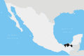
Macuspana is a city in Macuspana Municipality in the south-central part of the state of Tabasco in southeastern Mexico. The city of Macuspana had a 2005 census population of 30,661 and is the fifth-largest city in the state. It is the municipal seat of the municipality of Macuspana, which has an area of 2,551.7 km2 (985.22 sq mi) and a population of 142,954, which includes numerous smaller communities. The largest of these communities is Benito Juárez (San Carlos).

Contents

It is the birthplace of Andrés Manuel López Obrador, the current Mexican President.

Geography

The geographical vicinity is also known as the Macuspana Basin.

Climate

Climate data for Macuspana
MonthJanFebMarAprMayJunJulAugSepOctNovDecYear
Average high °C (°F)28.3
(82.9)
29.8
(85.6)
32.4
(90.3)
34.6
(94.3)
35.8
(96.4)
34.7
(94.5)
34.4
(93.9)
34.3
(93.7)
33.2
(91.8)
31.7
(89.1)
30.3
(86.5)
28.7
(83.7)
32.4
(90.3)
Average low °C (°F)18.1
(64.6)
18.7
(65.7)
20.1
(68.2)
22.0
(71.6)
23.1
(73.6)
23.2
(73.8)
22.9
(73.2)
22.9
(73.2)
22.9
(73.2)
22
(72)
20.6
(69.1)
19.0
(66.2)
21.3
(70.3)
Average precipitation mm (inches)150
(5.9)
120
(4.7)
69
(2.7)
66
(2.6)
120
(4.9)
300
(11.8)
200
(7.9)
270
(10.7)
400
(15.7)
340
(13.3)
210
(8.1)
160
(6.3)
2,400
(94.5)
Source: Weatherbase [1]

Name

The etymology of Macuspana's name is uncertain. The Enciclopedia de los municipios de México offers three possible explanations:

Related Research Articles

<span class="mw-page-title-main">Tekax</span> City in Yucatán, Mexico

Tekax, sometimes spelled Tecax, is a small city in the Mexican state of Yucatán, located at 20°12′07″N89°17′17″W in the southernmost part of the state. Tekax means "Place of the Forests" in the Yucatec Maya language. Tekax was briefly declared the capital of Yucatán in 1845. Tekax is also the name of the surrounding municipality of which the city of Tekax serves as municipal seat of government.

Las Choapas is a city and its surrounding municipality in the southeastern extremes of the state of Veracruz in Mexico. It is bordered by the municipalities of Uxpanapa, Minatitlán, Moloacán, and Agua Dulce in Veracruz, Huimanguillo in Tabasco, Cintalapa and Tecpatán in Chiapas, and Santa María Chimalapa in Oaxaca. Its major products are cattle breeding, corn, oil, fruit, sugar, and rubber. In the past it had a rice miller. It is one of the largest municipalities in Veracruz, with an area of 2,851.2 km². At the 2005 census the city had a population of 40,773 inhabitants, while the municipality had a population of 70,092. It is a very hot place, as temperature reaches up to 40 degrees Celsius. It has had some tornadoes in the past. It is connected to the communities of Raudales-Ocozocoautla in Chiapas through the Chiapas bridge.

<span class="mw-page-title-main">Acámbaro</span> City and municipality in Guanajuato, Mexico

Acámbaro is a city and municipality in the southeastern corner of the Mexican state of Guanajuato, on the banks of the Lerma River, and the oldest of the 46 municipalities of Guanajuato. Acámbaro was originally a Purépecha settlement which was invaded by the Spanish, and their Otomi allies, in 1526. Acámbaro is noted as a major railway junction, a local transport hub, and the origin of the nationally famous Acámbaro bread. The 2005 census population of the municipality was 101,762, and that of the city proper 55,082. The municipality covers an area of 877.8 km² and includes many small outlying communities, the largest of which are Iramuco and Parácuaro.

Jalapa is a small city in the Mexican state of Tabasco. It is located at 17°42′N92°48′W.

<span class="mw-page-title-main">Comalcalco</span>

Comalcalco is a city located in Comalcalco Municipality about 45 miles (60 km) northwest of Villahermosa in the Mexican state of Tabasco. Near the city is the Pre-Columbian Maya archaeological site of Comalcalco. The literal English translation of "Comalcalco" is "In the house of the comals". A comal is a pan used to prepare food.

<span class="mw-page-title-main">Tenosique</span>

Tenosique is a town located in Tenosique Municipality in the southeastern corner of the state of Tabasco, in Mexico. Its official name is Tenosique de Pino Suárez. The town had a 2020 census population of 34,946 inhabitants, while the municipality had a population of 62,310.

<span class="mw-page-title-main">Acaponeta</span> City in Nayarit, Mexico

Acaponeta is both a municipality and a town in the northern part of the Mexican state of Nayarit. The town is located at the geographical coordinates of 22°29′47″N105°21′34″W. The population of the municipality was 34,665 in the 2005 census, living in a total area of 1,667.7 km². The population of the municipal seat was 18,066, the fifth-largest community in the state. The Acaponeta River flows through the town. See maps at and

Acayucan Municipality is one of the 212 municipalities of the Mexican state of Veracruz. It is located in the state's southeast, in the Olmeca region. The municipal seat is the city of Acayucan, Veracruz. It covers a total of 724.65 km².

<span class="mw-page-title-main">Chicomuselo</span> Municipality in Chiapas, Mexico

Chicomuselo is a municipio (municipality) in the Mexican state of Chiapas, and also the name of the municipality's largest settlement and the seat of the municipal government. The municipality has an area of 1,043 km².

<span class="mw-page-title-main">Cárdenas, Tabasco</span>

Cárdenas is the second-largest city in the Mexican state of Tabasco, in southeastern Mexico. At the census of 2005 the city had a population of 79,875 inhabitants, while the municipality had 219,563 inhabitants. There are numerous smaller communities in the municipality, but the largest are Sánchez Magallanes and Campo Magallanes. The area of the municipality is 2,112 km².

<span class="mw-page-title-main">Santa Lucía del Camino</span> Municipality and town in Oaxaca, Mexico

Santa Lucía del Camino is a city and its surrounding municipality located in the central part of the Mexican state of Oaxaca. It lies just 3 km east of the state capital city of Oaxaca, within the Oaxaca metropolitan area. It is part of the Centro District in the Valles Centrales region.

<span class="mw-page-title-main">Izúcar de Matamoros</span>

Izúcar de Matamoros is a city in Izúcar de Matamoros Municipality located in the southwestern part of the Mexican state of Puebla. The city serves as the municipal seat of the municipality. At the census of 2005 the city had a population of 41,042 inhabitants, while the municipality had a population of 69,413. The municipality has an area of 514.11 km², and stands at 1100 m above sea level. Its largest other communities are the towns of La Galarza and San Juan Raboso. It has many sights like the portales, and Santo Domingo, the biggest church in the city.

<span class="mw-page-title-main">Abasolo, Guanajuato</span>

Abasolo is a Mexican city located in the Southwest region of the state of Guanajuato. The municipality has an area of 601.73 square kilometres, and is bordered to the north by Pueblo Nuevo and Valle de Santiago, to the south by the state of Michoacán and Huanímaro, and to the west by Pénjamo and Cuerámaro. The municipality had 79,093 inhabitants according to the 2005 census. The city was estimated to have 28,100 inhabitants in 2020.

<span class="mw-page-title-main">Armería</span> Municipality in Colima, Mexico

Armería is a municipality in the south-central part of the Mexican state of Colima. Ciudad de Armería is a city and the seat of Armería municipality. The municipality reported 29,599 inhabitants in the 2015 census and has an area of 341.60 km². Its municipal seat is Ciudad de Armería.

<span class="mw-page-title-main">Cunduacán</span> Place in Tabasco, Mexico

Cunduacán is a municipality in the central portion of the Mexican state of Tabasco, in Mexico. It is located at about 18°4'0"North, 93°10'0"West.

<span class="mw-page-title-main">Hopelchén Municipality</span> Municipality in Campeche, Mexico

Hopelchén is one of the 11 municipalities in the Mexican state of Campeche. It is situated inland in the north of the state. The municipal seat, and largest settlement, is the city of Hopelchén.

<span class="mw-page-title-main">Huimanguillo</span> Municipality in Tabasco, Mexico

Huimanguillo Municipality is a municipality in the Mexican state of Tabasco in south-eastern Mexico.

<span class="mw-page-title-main">Macuspana Municipality</span> Municipality in Tabasco, Mexico

Macuspana Municipality is a municipality in the Mexican state of Tabasco, in south-eastern Mexico. Its seat is the city of Macuspana. The municipality covers an area of 2,551 km2 (985 sq mi) and has a total population of 142,954 as of the 2005 census.

<span class="mw-page-title-main">Tacotalpa Municipality</span> Municipality in Tabasco, Mexico

Tacotalpa is a municipality in Tabasco in south-eastern Mexico.

<span class="mw-page-title-main">Teapa Municipality</span> Municipality in Tabasco, Mexico

Teapa Municipality is a municipality in Tabasco in south-eastern Mexico. Its name comes from the Nahuatl words "Tetl and apan", which mean "river over stones" or "stone's river". It refers to one of the rivers that crosses the town.

References

  1. "Weatherbase: Historical Weather for Macuspana, Tabasco". Weatherbase. 2011. Retrieved on November 24, 2011.

17°46′N92°36′W / 17.767°N 92.600°W / 17.767; -92.600