
Albuquerque, abbreviated as ABQ, is the most populous city in the U.S. state of New Mexico. The city's nicknames are The Duke City and Burque, both of which reference its 1706 founding by Nuevo México governor Francisco Cuervo y Valdés as La Villa de Alburquerque. Named in honor of then Viceroy the 10th Duke of Alburquerque, the Villa was an outpost on El Camino Real for the Tiquex and Hispano towns in the area. Since the city's founding, it has continued to be included on travel and trade routes including Santa Fe Railway (ATSF), Route 66, Interstate 25, Interstate 40, and the Albuquerque International Sunport. The 2019 census-estimated population of the city is 560,513, making Albuquerque the 32nd-most populous city in the United States and the fourth-largest in the Southwest. It is the principal city of the Albuquerque metropolitan area, which had 915,927 residents as of July 2018. The metropolitan population includes Rio Rancho, Bernalillo, Placitas, Zia Pueblo, Los Lunas, Belen, South Valley, Bosque Farms, Jemez Pueblo, Cuba, and part of Laguna Pueblo. This metro is included in the larger Albuquerque–Santa Fe–Las Vegas combined statistical area (CSA), with a population of 1,171,991 as of 2016. The CSA constitutes the southernmost point of the Southern Rocky Mountain Front megalopolis, including other major Rocky Mountain region cities such as Cheyenne, Wyoming, and Denver, Colorado, with a population of 5,467,633 according to the 2010 United States Census.
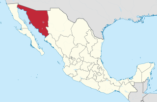
Sonora, officially Free and Sovereign State of Sonora, is one of 32 states which comprise the Federal Entities of Mexico. It is divided into 72 municipalities; the capital city is Hermosillo. Sonora is bordered by the states of Chihuahua to the east, Baja California to the northwest and Sinaloa to the south. To the north, it shares the U.S.–Mexico border primarily with the state of Arizona with a small length with New Mexico, and on the west has a significant share of the coastline of the Gulf of California.

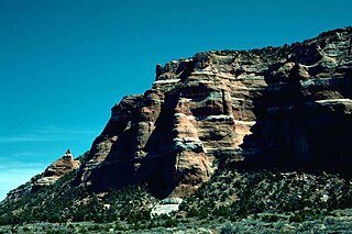
Silver City is a town in Grant County, New Mexico, United States. It is the county seat and the home of Western New Mexico University. As of the 2010 census the population was 10,315. In 2019 the population was estimated to be 9,386.
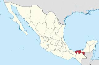
Tabasco, officially the Free and Sovereign State of Tabasco, is one of the 32 Federal Entities of Mexico. It is divided into 17 municipalities and its capital city is Villahermosa.

Michoacán, formally Michoacán de Ocampo, officially the Free and Sovereign State of Michoacán de Ocampo, is one of the 32 states which comprise the Federal Entities of Mexico. The state is divided into 113 municipalities and its capital city is Morelia. The city was named after José María Morelos, a native of the city and one of the main heroes of the Mexican War of Independence.

Puerto Vallarta is a Mexican beach resort city situated on the Pacific Ocean's Bahía de Banderas in the Mexican state of Jalisco. Puerto Vallarta is the second largest urban agglomeration in the state after the Guadalajara Metropolitan Area. The City of Puerto Vallarta is the government seat of the Municipality of Puerto Vallarta which comprises the city as well as population centers outside of the city extending from Boca de Tomatlán to the Nayarit border . The city is located at 20°40′N105°16′W. The municipality has an area of 1,300.7 square kilometres (502.19 sq mi). To the north, it borders the southwest part of the state of Nayarit. To the east, it borders the municipality of Mascota and San Sebastián del Oeste, and to the south, it borders the municipalities of Talpa de Allende and Cabo Corrientes.

Taxco de Alarcón is a small city and administrative center of Taxco de Alarcón Municipality located in the Mexican state of Guerrero. Taxco is located in the north-central part of the state, 36 kilometres from the city of Iguala, 135 kilometres from the state capital of Chilpancingo and 170 kilometres southwest of Mexico City.

Tlaxcala, officially the Free and Sovereign State of Tlaxcala, is one of the 32 states which comprise the Federal Entities of Mexico. It is divided into 60 municipalities and its capital city is Tlaxcala.
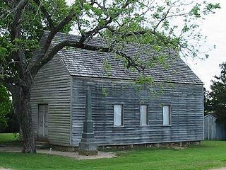
Washington-on-the-Brazos is an unincorporated community along the Brazos River in Washington County, Texas, United States. The town is best known for being the site of the Convention of 1836 and the signing of the Texas Declaration of Independence. As of 2009, the estimated population was 265.
Navojoa is the fifth-largest city in the northern Mexican state of Sonora and is situated in the southern part of the state. The city is the administrative seat of Navojoa Municipality, located in the Mayo River Valley.

Atoyac Municipality is a municipality in the Mexican state of Jalisco. The administrative centre for the municipality is located in the town of Atoyac, Jalisco.
Venustiano Carranza is a small city located in the northwestern part of the Mexican state of Michoacán, in the region of the Chapala Lake. The city is still better known for its former pre-Mexican revolution name San Pedro Caro, which derives from the town's patron saint and the last name of its original founders. Important spots in the town near the central square include a 17th-century church which has a clock tower. La Plaza is a town square structure that was recently renovated in 2005, which is packed on Sundays and town holidays and El Arco. There is a main farmer's market next to the municipal building and also a supermarket across the street. You can see mountains in the southeast part of town rumored to have a huge cross on a spot were La Virgin de Gaudalupe was seen.

Dzibilchaltún is a Maya archaeological site in the Mexican state of Yucatán, approximately 10 miles (16 km) north of state capital Mérida.

San Marcos is a town in the Mexican state of Guerrero. It serves as the municipal seat of the surrounding municipality of San Marcos.
The Zuni Indian Reservation, also known as Pueblo of Zuni, is the homeland of the Zuni tribe of Native Americans.
Soteapan is a municipality and city located in the south-central zone of the Mexican State of Veracruz, about 260 km from state capital Xalapa. As of 2000 the municipality counted 27,487 inhabitants within 528.07 km², including about 10,000 in the main city area of Soteapan.

Pahuatlán, officially Pahuatlán del Valle, is a town and municipality located in the northwest of the state of Puebla in central Mexico. The municipality is part of the Sierra Norte region of the state, a steep mountainous area which receive significant moisture from the Gulf of Mexico, and borders the states of Hidalgo and Veracruz.

The Patagonia Mountains are a 15-mile-long (24 km) mountain range within the Coronado National Forest, and in Santa Cruz County, Arizona, United States.
The following is a timeline of the history of the city of Villahermosa in Centro Municipality, Tabasco state, Mexico.

Boca Chica is an area on the eastern portion of a subdelta peninsula of Cameron County, at the far south of the US State of Texas along the Gulf Coast. It is bordered by the Brownsville Ship Channel to the north, the Rio Grande River and Mexico to the south, and the Gulf of Mexico to the east. The area extends approximately 25 miles (40 km) east of the city of Brownsville. The peninsula is served by Texas State Highway 4—also known as the Boca Chica Highway, or Boca Chica Boulevard within Brownsville city limits—which runs east-west, terminating at the Gulf and Boca Chica Beach.


