Tabasco, officially the Free and Sovereign State of Tabasco, is one of the 32 Federal Entities of Mexico. It is divided into 17 municipalities and its capital city is Villahermosa.
Las Choapas is a city and its surrounding municipality in the southeastern extremes of the Mexican state of Veracruz. It is bordered by the municipalities of Uxpanapa, Minatitlán, Moloacán, and Agua Dulce in Veracruz, Huimanguillo in Tabasco, Cintalapa and Tecpatán in Chiapas, and Santa María Chimalapa in Oaxaca. Its major products are cattle breeding, corn, oil, fruit, sugar, and rubber. In the past it had a rice miller. It is one of the largest municipalities in Veracruz, with an area of 2,851.2 km². At the 2005 census the city had a population of 40,773 inhabitants, while the municipality had a population of 70,092. It is a very hot place, as temperature reaches up to 40 degrees Celsius. It has had some tornadoes in the past. It is connected to the communities of Raudales-Ocozocoautla in Chiapas through the Chiapas bridge.
Tabasco is a state in Southeast Mexico that is divided into 17 municipalities. According to the 2020 Mexican census, it has the 20th largest population with 2,402,598 inhabitants and is the 24th largest by land area spanning 24,738 square kilometres (9,551 sq mi).

Tenosique is a town located in Tenosique Municipality in the southeastern corner of the state of Tabasco, in Mexico. Its official name is Tenosique de Pino Suárez. The town had a 2020 census population of 34,946 inhabitants, while the municipality had a population of 62,310.

Macuspana is a city in Macuspana Municipality in the south-central part of the state of Tabasco in southeastern Mexico. The city of Macuspana had a 2005 census population of 30,661 and is the fifth-largest city in the state. It is the municipal seat of the municipality of Macuspana, which has an area of 2,551.7 km2 and a population of 142,954, which includes numerous smaller communities. The largest of these communities is Benito Juárez.
Acayucan is a municipality in the Mexican state of Veracruz. It is located in the state's southeast, in the Olmeca region. The municipal seat is the city of Acayucan, Veracruz. It covers a total of 724.65 km2.

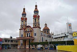
Cárdenas is the second-largest city in the Mexican state of Tabasco, in southeastern Mexico. At the census of 2005 the city had a population of 79,875 inhabitants, while the municipality had 219,563 inhabitants. There are numerous smaller communities in the municipality, but the largest are Sánchez Magallanes and Campo Magallanes. The area of the municipality is 2,112 km².

Armería is a municipality in the south-central part of the Mexican state of Colima. Ciudad de Armería is a city and the seat of Armería municipality. The municipality reported 29,599 inhabitants in the 2015 census and has an area of 341.60 km2. Its municipal seat is Ciudad de Armería.
Cunduacán is a municipality in the central portion of the Mexican state of Tabasco, in Mexico. It is located at about 18°4'0"North, 93°10'0"West.

Ixtlahuacán is a municipality in the Mexican state of Colima. The municipal seat lies at Ixtlahuacán. The municipality covers an area of 468.7 km².

Zaragoza is one of the 38 municipalities of Coahuila, a state in north-eastern Mexico. The municipal seat lies at Zaragoza. The municipality covers an area of 8183.5 km². It is near the Mexico–US border with Texas. It is one of the cities in the "5 manantiales" region in northern Coahuila. The celebrations commemorating Zaragoza's founding on 1 February 1753 are a popular attraction, and feature a traditional "cabalgata" or horse trail ride with horse pulled vintage buggies. On 7 August 1827, the name of the town was changed to San Fernando de Rosas, and to Zaragoza on the 27 February 1868.
Paraíso is a town and municipality located in the north of the Mexican state of Tabasco, about 75 km due north of the state capital of Villahermosa on the Gulf of Mexico. Much of the area is traditionally dedicated to fishing and agriculture. Today, it is also an oil-producing area with the mostly oil-dedicated port of Dos Bocas. There is also some tourism connected to the area's beaches and natural attractions, and the area is promoted under the state's Cacao Route tourism program.

Jalpa de Méndez Municipality is a municipality in the Mexican state of Tabasco in south-eastern Mexico.
Tacotalpa is a municipality in the Mexican state of Tabasco in south-eastern Mexico.
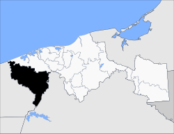
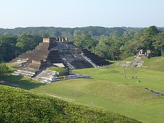
Chontalpa is a region in the northwest of the Mexican state of Tabasco, consisting of four municipalities. Although the name refers to the state's Chontal Maya population, modern Chontalpa is a subregion of the Grijalva Region, with boundaries defined by economic concerns. A large percentage of the state's Chontal Maya population does live in the region, with the municipality of Nacajuca having the largest concentration of Chontal Maya indigenous individuals, while the next largest concentration is found just east of the region, in the Villahermosa area. The Chontalpa economy is heavily dependent on agriculture, especially livestock, as well as on its oil industry. The reliance on these sectors has prompted conflict since the 20th century, as the environmental effects of the oil industry have caused concerns of effects on agriculture. Chontalpa is also home to Tabasco's two main archeological sites, La Venta and Comalcalco, along with numerous smaller sites.

Legislative elections were held in Mexico on 7 June 2015, alongside municipal elections.

Acala is a municipality in the Mexican state of Chiapas, in southern Mexico. The municipal seat is Acala.
Mezcalapa is a municipality in the Mexican state of Chiapas, located approximately 71 kilometres (44 mi) northwest of the state capital of Tuxtla Gutiérrez. Its municipal seat is Raudales Malpaso.

Paraíso is a municipality in Tabasco in south-eastern Mexico.
José Sabino Herrera Dagdug is a Mexican politician from the state of Tabasco. Previously affiliated with the Party of the Democratic Revolution (PRD), as a senator-elect for his home state he joined the ranks of the National Regeneration Movement (Morena) on 28 August 2024.