Maddingley

Last updated
Maddingley
Bacchus Marsh,  Victoria
BacchusMarshChicoryKiln.JPG
The heritage-listed chicory kiln in Maddingley
Australia Victoria Moorabool Shire location map.svg
Red pog.svg
Maddingley
Coordinates 37°41′11″S144°26′01″E / 37.68639°S 144.43361°E / -37.68639; 144.43361 Coordinates: 37°41′11″S144°26′01″E / 37.68639°S 144.43361°E / -37.68639; 144.43361
Population3,453 (2016 census) [1]
Postcode(s) 3340
Location
LGA(s) Shire of Moorabool
State electorate(s) Melton
Federal Division(s) Ballarat
Suburbs around Maddingley:
Bacchus Marsh Bacchus Marsh Bacchus Marsh
Rowsley Maddingley Hopetoun Park
Rowsley Parwan Parwan

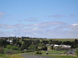
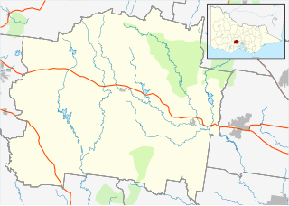
Maddingley is a suburb of Bacchus Marsh, a peri-urban town in central Victoria, Australia. The locality consists of the portion of the Bacchus Marsh urban area south of the Werribee River. It is in the Shire of Moorabool, 61 kilometres (38 mi) west north west of the state capital, Melbourne. At the 2016 census, Maddingley had a population of 3,453. [1]
Bacchus Marsh Town in Victoria, Australia

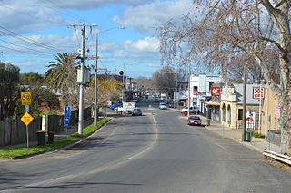
Bacchus Marsh is an urban centre and suburban locality in Victoria, Australia located approximately 50 kilometres (30 mi) north west of the state capital Melbourne and 14 kilometres (9 mi) west of Melton at a near equidistance to the major cities of Melbourne, Ballarat and Geelong. The population of the Bacchus Marsh urban area was 20,345 at the 2016 Census. Bacchus Marsh is the largest urban area in the local government area of Shire of Moorabool.

Victoria (Australia) State in Australia

Victoria is a state in south-eastern Australia. Victoria is Australia's smallest mainland state and its second-most populous state overall, making it the most densely populated state overall. Most of its population lives concentrated in the area surrounding Port Phillip Bay, which includes the metropolitan area of its state capital and largest city, Melbourne, Australia's second-largest city. Victoria is bordered by Bass Strait and Tasmania to the south, New South Wales to the north, the Tasman Sea to the east, and South Australia to the west.

Werribee River river to the west of Melbourne, Victoria, Australia

The Werribee River is a perennial river of the Port Phillip catchment that is located on the plain west of Melbourne, Victoria, Australia. The headwaters of a tributary, the Lerderderg River, are north of Ballan near Daylesford and it flows across the basalt plain, through the suburb of Werribee to enter Port Phillip. A linear park follows the Werribee River along much of its course. In total the Werribee River completes a journey of approximately 110 kilometres (68 mi).

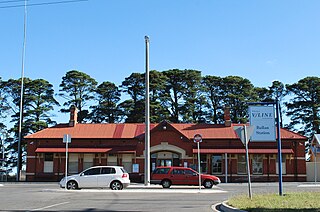
Items of interest in Maddingley include the Bacchus Marsh railway station, Bacchus Marsh College, Bacchus Marsh Grammar School and the Maddingley brown coal mine. Maddingley Park, including the Nieuwesteeg Heritage Rose Garden, is adjacent to the railway station.
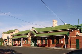
Bacchus Marsh railway station railway station in Maddingley, Victoria, Australia

Bacchus Marsh railway station is located on the Serviceton line, in Victoria, Australia. It serves the town of Bacchus Marsh, and opened on 10 February 1887, as the temporary terminus of the line from Melbourne. On 4 December 1889, the line was extended to Ballan, which completed the direct Melbourne to Ballarat line.

Bacchus Marsh College

Bacchus Marsh College is a secondary school in the town of Bacchus Marsh, Victoria, Australia. It was opened in 1912 as Bacchus Marsh High School, and then later became Bacchus Marsh Secondary College. The college started with 38 students.

Bacchus Marsh Grammar School is an independent, co-educational primary school and secondary school, a day school located in Bacchus Marsh, Victoria, Australia.

Related Research Articles

Melton, Victoria Suburb of Melbourne, Victoria, Australia

Melton is an urban area within metropolitan Melbourne, Australia located 35 km west from the capital's central business district. It is the administrative centre of the City of Melton local government area and its most populous centre. At June 2016 Melton had an estimated urban population of 62,117. It is considered part of the Greater Melbourne metropolitan area and is included in the capital's population statistical division.

Shire of Moorabool Local government area in Victoria, Australia

The Shire of Moorabool is a local government area in Victoria, Australia, located in the western part of the state. It covers an area of 2,110 square kilometres (810 sq mi) and, at the 2016 Census, had a population of 31,818. It includes the towns of Ballan, Bacchus Marsh, Balliang, Mount Wallace, Myrniong, Blackwood, Greendale, Gordon, Korweinguboora and Mount Egerton, Bungaree, Elaine and Wallace. It was formed in 1994 from the amalgamation of the Shire of Bacchus Marsh, Shire of Ballan and parts of the Shire of Bungaree and City of Werribee.

Melton South, Victoria Suburb of Melbourne, Victoria, Australia

Melton South is a suburb of Melbourne, Victoria, Australia, 35 km west of Melbourne's Central Business District, located within the City of Melton local government area. Melton South recorded a population of 11,517 at the 2016 Census.

Ballan railway station railway station in Ballan, Victoria, Australia

Ballan railway station is located on the Serviceton railway line, in Victoria, Australia, serving the town of Ballan. It opened on 22 December 1886, as the terminus of a short line from Ballarat. On 4 December 1889, the line was extended to Bacchus Marsh, meaning that trains could then run from Melbourne to Ballarat via Ballan.

Bacchus Marsh Football and Netball Club, is located in Bacchus Marsh in Victoria, Australia and competes in the Ballarat Football League, which is part of the Victorian Country Football League. The home ground of Bacchus Marsh is Maddingley Park, located to the south of Bacchus Marsh.

Myrniong Town in Victoria, Australia

Myrniong is a town in Victoria, Australia. The town is near the Western Freeway, 72 kilometres (45 mi) north west of the state capital, Melbourne and 15 kilometres (9 mi) west of Bacchus Marsh. Situated close by the Lerderderg River, at the 2016 census, Myrniong had a population of 404. The town is in the eastern area of Shire of Moorabool local government area.

Parwan railway station

Parwan is a closed station located in the town of Parwan, near Bacchus Marsh, on the Ararat railway line in Victoria, Australia. The station platform was on the southern side of the line. Today, Parwan is a crossing loop, permitting trains up to 969 metres long to cross.

Parwan, Victoria Town in Victoria, Australia

Parwan is a town in Victoria, Australia, 45 km west of Melbourne's Central Business District. Predominantly Parwan lies within the local government area (LGA) of the Shire of Moorabool, but some of Parwan lies within the LGA of the City of Melton. Parwan recorded a population of 170 at the 2016 Census.

Bullengarook, Victoria Town in Victoria, Australia

Bullengarook is a locality in Victoria, Australia. The locality is centred on Bacchus Marsh Road, 14 kilometres (9 mi) west of Gisborne and 19 km north of Bacchus Marsh. Bullengarook is in the Shire of Macedon Ranges local government area. At the 2011 Census, Bullengarook and the surrounding area had a population of 603. Mount Bullengarook, the Lerderderg State Park and the headwaters of Coimadai Creek are found to the south of the township.

Ballarat V/Line rail service passenger rail service in Victoria, Australia

The Ballarat V/Line rail service is a regional passenger rail service operated by V/Line in Victoria, Australia. It serves passengers between state capital Melbourne and the regional city of Ballarat. Beyond Ballarat it changes name to the Ararat railway line and the Maryborough railway line.

Shire of Bacchus Marsh Local government area in Victoria, Australia

The Shire of Bacchus Marsh was a local government area about 50 kilometres (31 mi) west of Melbourne, the state capital of Victoria, Australia. The shire covered an area of 565 square kilometres (218.1 sq mi), and existed from 1862 until 1994.

Caroline Springs railway station railway station in Ravenhall, Melbourne, Victoria, Australia

Caroline Springs railway station is a railway station on the Serviceton line in Victoria, Australia.

Darley, Victoria Suburb of Bacchus Marsh, Victoria, Australia

Darley is a suburb of Bacchus Marsh, Victoria, Australia located directly north of the central area across the Western Freeway. It is the most populous locality and earliest settlement (1838) in Bacchus Marsh. At the 2016 census, Darley had a population of 8,372.

Maddingley Mine near Bacchus Marsh Railway Station, Victoria, Australia contains a concentration of a particular brown coal (lignite) formation called Leonardite. A relatively high altitude formation, Maddingley brown coal is distinguished as having 60 per cent moisture content and a rich fulvic acid and humic acid content. A declared strategic State mining reserve, the estimated 400 million tonne deposit at Maddingley is the largest of three known deposits of high value Leonardite in the world, the others occurring in Mexico and Germany.

Nieuwesteeg Heritage Rose Garden

Nieuwesteeg Heritage Rose Garden is a collection of rare and unusual roses, mostly hybrid teas, bred in the early 20th century. It is located in Maddingley Park, Bacchus Marsh, a town and suburb some 50 kilometres (30 mi) west of Melbourne and 14 kilometres (9 mi) west of Melton. The rose garden was established from 2009, with stock donated by rosarian John Nieuwesteeg.

Hopetoun Park, Victoria Suburb of Bacchus Marsh, Victoria, Australia

Hopetoun is a rural residential suburb of Bacchus Marsh, a peri-urban town in central Victoria, Australia. The locality consists of the area between the Bacchus Marsh urban area and Melton, north of the Werribee River and south of the Western Highway. It is in the Shire of Moorabool, 51 kilometres (32 mi) west north west of the state capital, Melbourne.

References

  1. 1 2 Australian Bureau of Statistics (27 June 2017). "Maddingley". 2016 Census QuickStats. Retrieved 21 July 2017. Blue pencil.svg

Commons-logo.svg Media related to Maddingley at Wikimedia Commons