
Madurai is a major city in the Indian state of Tamil Nadu. It is the cultural capital of Tamil Nadu and the administrative headquarters of Madurai District, the third largest city in Tamil Nadu and 44th most populated city in India. Located on the banks of River Vaigai, Madurai has been a major settlement for two millennia.
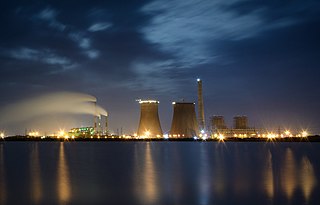
Thoothukudi is a port city and a municipal corporation and an industrial city in Thoothukudi district in the Indian state of Tamil Nadu. The city lies in the Coromandel Coast of Bay of Bengal. Thoothukudi is the capital and headquarters of Thoothukudi district. It is located about 590 kilometres southwest of Chennai, 190 kilometres northeast of Thiruvananthapuram and 580 kilometres southesst of Bengaluru. According to Confederation of Indian Industry, Thoothukudi has the second highest Human Development Index in Tamil Nadu next to Chennai. Thoothukudi City serves as the headquarters of Tamilnad Mercantile Bank Limited. Major educational establishments in the city include Government Thoothukudi Medical College, Fisheries College and Research Institute, Tamil Nadu Maritime Academy, V.O. Chidambaram College, Kamaraj College, Anna University and Government Polytechnic College. V. O. Chidambaranar Port Trust is one of the fastest growing Major Ports in India. Thoothukudi is an "Emerging Energy and Industrial hub of South India".

Palakkad Gap or Palghat Gap is a low mountain pass in the Western Ghats between Coimbatore in Tamil Nadu and Palakkad in Kerala. It has an average elevation of 140 metres (460 ft) with a width of 24–30 kilometres (15–19 mi). The pass is located between the Nilgiri Hills to the north and Anaimalai Hills to the south.
Urapakkam is a census town in Chengalpattu district and a sub urban area of Chennai City located 16 kms from Chennai International airport on the GST Road in the Indian state of Tamil Nadu. It is part of the newly created Vandalur taluk. It had a population of 29,122 as per the 2011 census.The town has grown tremendously in the last decade.The town in bifurcated as East and West by the NH 32 and in fact, GST road is the busiest road in the Tamil Nadu State and also by the EMU railway line running between Chennai Beach and Chengalpattu. Urapakkam has a railway station in the EMU line.

Tamil Nadu has the second-largest economy in India. Over 60% of the state is urbanized, accounting for 10.6% of the urban population in the country, while only comprising 6% of India's total population. Services contributes to 45% of the economic activity in the state, followed by manufacturing at 34% and agriculture at 21%. Government is the major investor in the state, with 52% of total investments, followed by private Indian investors at 29.9% and foreign private investors at 14.9%. It has been ranked as the first most economically free state in India by the Economic Freedom Rankings for the States of India.
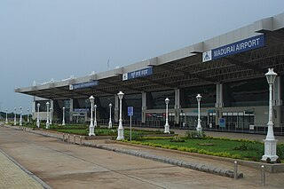
Madurai Airport is an international airport serving Madurai and its surrounding districts in the Indian state of Tamil Nadu. It is the 32nd busiest airport in India for passengers handled, 32nd busiest for total aircraft movement. The airport is located near State Highway 37 about 12 km (7.5 mi) from the Madurai railway station. It was established in 1957.

State Highway 49A also known as Rajiv Gandhi Salai and Rajiv Gandhi IT Expressway or just IT Expressway is a major road connecting Chennai, Tamil Nadu with Mahabalipuram in Kanchipuram district, Tamil Nadu. It is 45 km long and was earlier known as the Old Mahabalipuram Road (OMR). The road starts from Madhya Kailash Temple on Sardar Patel Road in South-East Chennai and terminates on East Coast Road near Mahabalipuram.

The Vaigai Dam is built across the Vaigai River near Andipatti, in the Theni district of Tamil Nadu, southern India. It provides water for irrigation for the Madurai district and the Dindigul district as well as drinking water to Madurai and Andipatti. Near the dam, the Government of Tamil Nadu has constructed an Agricultural Research Station for researching the growing of a variety of crops, including rice, sorghum, blackgram, cowpea and cotton.
National Highway 44 is the longest-running major north–south National Highway in India. It begins from Srinagar and terminates in Kanyakumari; the highway passes through the Union Territory of Jammu and Kashmir, as well as the states of Punjab, Haryana, Delhi, Uttar Pradesh, Rajasthan, Madhya Pradesh, Maharashtra, Telangana, Andhra Pradesh, Karnataka, and Tamil Nadu. NH-44 was constructed and is maintained by Central Public Works Department (CPWD).
Chennai High Speed Circular Transportation Corridors (HSCTC) is an urban road transit in the form of elevated concentric beltways planned for the city of Chennai. The beltways are envisaged as an elevated 2-tier system with design speed of 80 km/h. The top tier is a 2-lane dedicated corridor for the Chennai BRTS system. The second tier is a 4-lane road for 4-wheelers.
State Highway 58 is a State Highway in Kerala, India that starts in Vadakkancherry and ends in Pollachi. The highway is 39 km long.

In Tamil Nadu, the Highways & Minor Ports Department (HMPD) is primarily responsible for construction and maintenance of roads including national highways, state highways and major district roads. HMPD was established as Highways Department (HD) in April 1946 and subsequently renamed on 30 October 2008. It operates through seven wings namely National Highways Wing, Construction & Maintenance Wing, NABARD and Rural Roads Wing, Projects Wing, Metro Wing, Tamil Nadu Road Sector Project Wing, Investigation and Designs Wing geographically spread across the state in 32 districts with about 120 divisions and 450 subdivisions.

Tiruchirappalli has a well-developed transport infrastructure. Being located almost at the geographic centre of the state Tamil Nadu India, Trichy is well connected by Road, Rail and Air with most cities.

Tamil Nadu, a state in South India, has a highly developed, dense, and modern transportation infrastructure, encompassing both public and private transport. Its capital city, Chennai is well-connected by land, sea, and air and serves as a major hub for entry into South India.
M. K. Ashok is an Indian politician and was a member of the 14th Tamil Nadu Legislative Assembly from the Velachery constituency in Chennai District. He represented the All India Anna Dravida Munnetra Kazhagam party.

Vivek Express is a chain of express trains on the Indian Railways network. These trains were announced in the Railway Budget of 2011-12 by the then Railway Minister. These trains were started to commemorate the 150th birth anniversary of Swami Vivekananda, to be held in 2013. One of the Vivek Express trains, the one from Dibrugarh to Kanyakumari, is the longest route on the Indian Railways network, in terms of distance and time, and is currently the 24th longest in the world.
Tiruchirappalli Monorail is the proposed monorail system for the city of Tiruchirappalli, Tamil Nadu, part of a major expansion of public transport in the city.
National Highway 87 is a National Highway in southern India. It crosses the Pamban Bridge before entering into Rameswaram island. The total length runs up to 154 km (96 mi). The 5 km road between Mukundarayar Chathiram and Dhanuskodi was destroyed during the 1964 cyclone. Then the Government of India has started construction of the new stretch of road on 2015 and opened to vehicles with some restrictions on Feb'2017 at a cost of INR 250 million. At the same time, the road between Madurai and Rameswaram was converted from a two lane road to a four-lane highway. Then Union minister for road transport and shipping Shri.Nitin Gadkari laid the foundation stone for the Rs 1,387-crore project in Madurai on 17 July 2015. An initial outlay of Rs 927 crore was made {May 2019} and the project has been sanctioned for Rs 1,387 crore. Then the first 75km stretch from Madurai to Paramakudi was proposed to be converted into a proper four-lane road which is a Green Highway, while the remaining 39km stretch from Paramakudi to Ramanathapuram was widened as a two-lane road with paved shoulders. This road includes byepass from Madurai to Manalur which is a newly constructed route skipping the old route(which runs through Puliyankulam and Silaiman), and has byepasses at several places like Thiruppuvanam, Thiruppachethi, Rajagambiram, Paramakudi and Ramanathapuram which would substantially ease traffic congestion in these towns and also saves time for those tourists who are going to Rameswaram. Falling under the Old NH-49, this project is one of the largest completed green corridor in Tamil Nadu by the National Highways Authority of India in the recent times.

Coimbatore Metro is also known as Kovai Metro is proposed metro rail system for the city of Coimbatore, Kovai metropolitan area, Tamil Nadu.