
The Chennai Mass Rapid Transit System, commonly referred to as Chennai MRTS, is a metropolitan rail transit system in Chennai, India. It is operated by Southern Railway of the state-owned Indian Railways. Opened in 1995, it was the first elevated railway line in India. The railway line runs from Chennai Beach to Velachery, covering a distance of 19.34 km (12.02 mi) with 18 stations and is integrated with the wider Chennai suburban railway network.
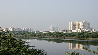
Sholinganallur, also spelled Solinganalloor or Sozhinganalloor, is a southern suburb of Chennai, India.
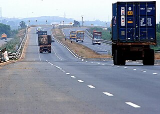
The Chennai Bypass Road is a full-access controlled expressway that interconnects four radial Indian National Highways around Chennai, India covering a distance of 32 km (20 mi) from Perungalathur on NH-32 to puzhal on NH-16 via Maduravoyal at a cost of ₹ 4.05 billion. Constructed as part of the National Highway Development Project to decongest the city of transiting vehicles, the expressway interconnects NH-32, NH-48, NH-716 and NH-16. This expressway now forms a part of the circular transportation corridor.

Tholkappia Poonga or Adyar Eco Park is an ecological park set up by the Government of Tamil Nadu in the Adyar estuary area of Chennai, India. According to the government, the project, conceived based on the master plan for the restoration of the vegetation of the freshwater ecosystems of the Coromandel Coast, especially the fragile ecosystem of the Adyar estuary and creek, was expected to cost around ₹ 1,000 million which will include the beautification of 358 acres of land. The park's ecosystem consists of tropical dense evergreen forest, predominantly comprising trees and shrubs that have thick dark green foliage throughout the year, with over 160 woody species, and comprises six vegetative elements such as trees, shrubs, lianas, epiphytes, herbs and tuberous species. The park was opened to public by Chief Minister M. Karunanidhi on 22 January 2011 and named after the renowned Tamil scholar Tholkappiar. About 65 percent of the park is covered by water and artefacts and signages. In the first 2 months of its inauguration, nearly 4,000 children from several schools in the city and the nearby Kancheepuram and Tiruvallur districts have visited the park to learn about wetland conservation, eco-restoration and water management. While the first phase of the ecopark covered about 4.16 acres of CRZ-III area, the entire area covered under the second phase falls under this category.
The Chennai Port – Maduravoyal Expressway is a 20.6-kilometre (12.8 mi) long, six-lane, double-decker elevated expressway under construction in the city of Chennai, Tamil Nadu, India. The corridor begins at Chennai Port Gate No. 10 and travels along the bank of the Cooum River till it reaches Koyambedu and along the median of NH 48 thereon till it reaches Maduravoyal. It is also called Elevated Freeway of India.
The Chennai Rapid Bus Transit Ways (RBTW) is a part of the Medium-term and Long-term Transport Scheme proposed in the Second Master Plan by the Chennai Metropolitan Development Authority (CMDA). This is not a part of Chennai BRTS, which is proposed on a separate elevated road that is to be constructed as circular corridors.
Chennai Monorail was a proposal for a number of lines as part of mass transit system for the Indian city of Chennai. Originally the city planned to use monorail on all lines but many were subsequently changed to railways as part of the Chennai Metro.
Chennai High Speed Circular Transportation Corridors (HSCTC) is an urban road transit in the form of elevated concentric beltways planned for the city of Chennai. The beltways are envisaged as an elevated 2-tier system with design speed of 80 km/h. The top tier is a 2-lane dedicated corridor for the Chennai BRTS system. The second tier is a 4-lane road for 4-wheelers (no buses and autos).
The East Coast Elevated Expressway is a proposed 9.7 kilometres (6.0 mi) elevated expressway in the city of Chennai, India. It runs along the coast of Bay of Bengal crossing Adyar Estuary passing by the western side of Broken bridge, Chennai. This corridor is being implemented by the Tamil Nadu Highways Department in two phases and forms a part of circular transportation corridors.

The Inner Ring Road (IRR), also known as Jawaharlal Nehru Salai or 100-Feet road or State Highway 2, is a major transportation corridor encircling the city of Chennai. It was developed by the Chennai Metropolitan Development Authority (CMDA). It is 25.2 km long with three distinct arms viz., Northern arm, Central arm and Southern arm, connecting SH 49A in Tiruvanmiyur, Velachery main road at Vijayanagar, NH 32 at Kathipara, NH 4 at Koyambedu, NH 205 at Padi, NH 5 at Madhavaram and joining SH 104 at Manali.
Moolakadai, which is pronounced as 'Moolakkadai', is a part of North Chennai, Tamil Nadu, India. It is the gateway of North Chennai.

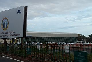
In Tamil Nadu, the Highways & Minor Ports Department (HMPD) is primarily responsible for construction and maintenance of roads including national highways, state highways and major district roads. HMPD was established as Highways Department (HD) in April 1946 and subsequently renamed on 30 October 2008. It operates through seven wings namely National Highways Wing, Construction & Maintenance Wing, NABARD and Rural Roads Wing, Projects Wing, Metro Wing, Tamil Nadu Road Sector Project Wing, Investigation and Designs Wing geographically spread across the state in 38 districts with about 120 divisions and 450 subdivisions.
Coimbatore is a city in the state of Tamil Nadu, India. Most transportation in the city and suburbs is by road. Coimbatore is well-connected to most cities and towns in India by road, rail, and air, but not through waterways. The city has successful transport infrastructure compared to other Indian cities, though road infrastructures are not well maintained and developed according to the growing needs of transport, making traffic congestion a major problem in the city. A comprehensive transport development plan has been made to address many traffic problems.
As of 2019, there are 632 parks in Chennai City, including 142 parks in the north zone, 224 in the central zone, and 266 in the south zone. They range in size from 700 square metres to 5,000 square metres. A couple of the parks, including the Anna Nagar Tower Park, are spread across acres. In 2018, the city's green cover was estimated to be 14.9 percent, up from an estimated 4.5 percent in 2011. The per capita green cover of the city has been estimated at 8.5 square meters, as against the World Health Organization recommendation of 9 square meters of green cover per capita in cities. The city lost around 100,000 trees in December 2016 because of Cyclone Vardah. As of 2018, the city's tree cover is estimated to be around 64.06 sq km. This is just over 15 percent of the entire city. The most dominant species of trees in the city are copper pod, Indian beech, neem, gulmohar, raintree, and tropical almond. The overall extent of open space in the city is 34.58 km2. In all, the city has 121 species of trees belonging to 94 genera and 42 families. Teynampet zone remains the most diverse with 68 species, and Manali zone with just 38 species is the least. With 51 parks, Adyar remains the zone with the highest number of parks in the city, and Tiruvottiyur zone scores the least with only 4 parks. The share of Chennai's greenspace is dominated by the Guindy National Park, with an area of 2.71 sq km, which covers a vast area south of the Adyar River.
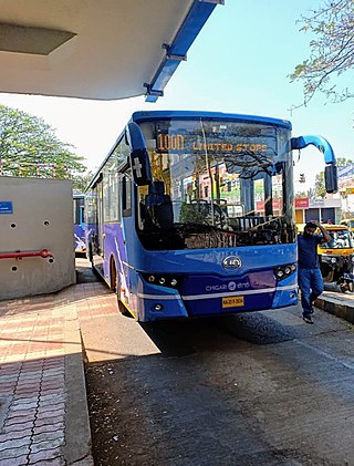
Hubli-Dharwad Bus Rapid Transit System (HDBRTS) is a bus rapid transit system built to serve the twin cities of Hubali and Dharwad, located in the North-Western part of Karnataka state in India. Hubali-Dharwad BRTS (HDBRTS) project is a Government of Karnataka initiative to foster long-term economic growth in the region. The project promotes fast, safe, comfortable, convenient and affordable public transportation between the twin cities and aims to reduce congestion and air pollution in the region.

Vadapalani is an elevated metro station on the South-East Corridor of the Green Line of Chennai Metro in Chennai, India. This station serves the neighbourhoods of Vadapalani and Kodambakkam and is one of the major stations on the Koyambedu-Alandur stretch and became operational by early 2015.

Rainbow BRTS is a bus rapid transit system in the city of Pune. The system is operated by the Pune Mahanagar Parivahan Mahamandal Limited (PMPML). The infrastructure has been developed by the Pune Municipal Corporation & Pimpri Chinchwad Municipal Corporation, Pune. The project currently envisages 113 km of dedicated bus corridors along with buses, bus stations, terminals and intelligent transit management system.
Coimbatore Metro, also known as Kovai Metro, is a proposed rapid transit system for Coimbatore, Tamil Nadu.
Perungavoor, is a suburb located North of Chennai, a metropolitan city in Tamil Nadu, India.
The Purple Line or Line 3 is one of the planned lines of Chennai Metro. It is part of the second phase of the project and the under construction line stretches from Madhavaram Milk Colony to Siruseri SIPCOT. The 45.4 km (28.2 mi) long line will consist of 47 stations, out of which 28 will be underground and 19 will be at grade or elevated.