
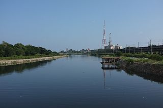
Kodambakkam Bridge is a road overbridge in the city of Chennai, India. Opened in 1965, it is one of the oldest overbridges in the city. The bridge has a length of 623 meters. [1]
Kodambakkam Bridge is a road overbridge in the city of Chennai, India. Opened in 1965, it is one of the oldest overbridges in the city. The bridge has a length of 623 meters. [1]
Prior to the construction of the bridge, there was a railway crossing at Kodambakkam, one of the busiest in the city. Choked by heavy traffic, the construction of a bridge was first proposed in the Lok Sabha in the late 1950s. [2] Eventually, the Madras State Highways Department took up the construction of a bridge in September 1963 and completed it in September 1965.

Chennai, formerly known as Madras, is the capital city of the Indian state of Tamil Nadu. The state's largest city in area and population as well, Chennai is located on the Coromandel Coast of the Bay of Bengal, and is the most prominent cultural, economic and educational centre of South India.

The Buckingham Canal is a 796 kilometres (494.6 mi)-long fresh water navigation canal, that parallels the Coromandel Coast of South India from Kakinada City in the Kakinada district of Andhra Pradesh to Viluppuram District in Tamil Nadu. The canal connects most of the natural backwaters along the coast to Chennai (Madras) port.

The Greater Chennai Corporation, formerly known as the Corporation of Madras (1688-1996) and Corporation of Chennai (1996-2016), is the civic body that governs the city of Chennai in the Indian state of Tamil Nadu. Inaugurated on 29 September 1688, under a royal charter issued by King James II of England on 30 December 1687 as the Corporation of Madras, it is the oldest municipal body of the Commonwealth of Nations outside Great Britain. It is among the oldest municipalities in Asia after Daman Municipality, which was established in 1588. It is the largest municipal corporation in Tamil Nadu with an area of 426 km2. It is headed by a mayor, who presides over 200 councillors, each of whom represents one of the 200 wards of the city. It is the second oldest civic corporation in the world after the City of London.
The Cooum river is one of the shortest classified rivers draining into the Bay of Bengal. This river is about 72 km (45 mi) in length, flowing 32 km (20 mi) in the city of Chennai and the rest in rural part. The river is highly polluted in the urban area (Chennai). Along with the Adyar River running parallel to the south and the Kosasthalaiyar River, the river trifurcates the city of Chennai and separates Northern Chennai from Central Chennai.

Puratchi Thalaivar Dr. M.G. Ramachandran Central Railway Station, commonly known as Chennai Central, is the main railway terminus in the city of Chennai, Tamil Nadu, India. It is the busiest railway station in South India and one of the most important hubs in the country. It is connected to Moore Market Complex railway station, Chennai Central metro station, Chennai Park railway station, Chennai Park Town railway station and is 2 km from Chennai Egmore railway station. The terminus connects the city to northern India, including Kolkata, Mumbai, New Delhi as well as to Bangalore, Ahmedabad, Guwahati, Chandigarh, Kerala,Hyderabad and different parts of India.

The Chennai Metro is a rapid transit system serving the city of Chennai, Tamil Nadu, India. It is the 4th longest metro system In india. The system commenced service in 2015 after partially opening the first phase of the project. The network consists of two colour-coded lines covering a length of 54.65 kilometres (33.96 mi). The Chennai Metro Rail Limited (CMRL), a joint venture between Government of India and the Government of Tamil Nadu built and operates the Chennai Metro. The system has a mix of underground and elevated stations and uses standard gauge. The services operate daily between 4:30 and 23:00 with a varying frequency of 5 to 14 minutes.

The Chennai Suburban Railway is a commuter rail system in the city of Chennai, Tamil Nadu, India, operated by the Southern Railways branch of Indian Railways. It is the second largest suburban rail network in terms of route length and the third largest in terms of commuters in India. Around 1,000 services are operated daily between 4:00 a.m. and midnight. It is the longest suburban circular route in India covering of 235.5 km (146.3 mi).
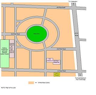
United India Colony is a sub-division of Kodambakkam, Chennai, India. United India Colony is a planned residential area and is a relatively greener locality in Chennai.

Panagal Park is a park and a locality in Thyagaraya Nagar, Chennai. The park is named after the Raja of Panagal, the Chief Minister of Madras Presidency who created the park. It is an important junction and is the commercial centre of T. Nagar.
Arcot Road(SH-113) is one of the main arterial roads of the city of Chennai in Tamil Nadu, India. It runs for 12 kilometres and connects Nungambakkam with Porur. The road was constructed during the early 1940s and has been responsible for the development of the outlying areas on the western fringes of Chennai city.

The Adyar or Adayar, originating near the Chembarambakkam Lake in Kanchipuram district, is one of the three rivers which winds through Chennai (Madras), Tamil Nadu, India, and joins the Bay of Bengal at the Adyar estuary. The 42.5-kilometre (26.4 mi) long river contributes to the estuarine ecosystem of Chennai. Despite the high pollution levels, boating and fishing take place in this river. The river collects surplus water from about 200 tanks and lakes, small streams and the rainwater drains in the city, with a combined catchment area of 860 square kilometres (331 sq mi). Most of the waste from the city is drained into this river and the Cooum.

Villivakkam railway station is a railway station on the Chennai Central–Arakkonam section of the Chennai Suburban Railway Network a city of Chennai in India. Located 9 km from Chennai Central railway station, the station serves the neighbourhood of Villivakkam, Kolathur and Padi. It has an elevation of 10.25 m above sea level.
Hindu College railway station, Chennai is one of the railway stations of the Chennai Central–Arakkonam section of the Chennai Suburban Railway Network. Located about 24 km from Chennai Central railway station, the station serves the neighbourhoods of Pattabiram a suburb of Chennai. It has an elevation of 28 m above sea level.
Pattabiram railway station is one of the railway stations of the Chennai Central–Arakkonam section of the Chennai Suburban Railway Network. Located about 25 km from Chennai Central railway station, it is a suburb situated on the western part of Chennai, India. the station serves the neighbourhoods of Pattabiram. It has an elevation of 31 m above sea level.

Arignar Anna Alandur Metro, commonly known as the Alandur Metro, is an elevated metro station that is part of the Blue Line and the Green Line of the Chennai Metro, and serves as an interchange station between the two lines. The station is one of the two metro stations where the two lines intersect, the other being the Chennai Central metro station. It is the city's first multi-level railway station. It is the only station where passengers from the two corridors can swap the direction of travel. On 31 July 2020, It has been named by Government of Tamil Nadu as Arignar Anna Alandur Metro to honor the DMK founder and the former Chief Minister of Tamil Nadu C. N. Annadurai.
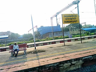
Korukkupet railway station is one of the railway station of the Chennai Central–Gummidipoondi section of the Chennai Suburban Railway Network. It serves the neighbourhood of Korukkupet, a suburb of Chennai, and is located 4 km north of Chennai Central railway station. It has an elevation of 7 m above sea level.

Mambalam Railway Station is one of the railway stations in Chennai, India, on the Chennai Beach–Chengelpet section of the Chennai Suburban Railway Network. It serves the neighbourhoods of West Mambalam and T. Nagar. It is situated between the two neighbourhoods, about 11 km (6.8 mi) from Chennai Beach, and has an elevation of 13 m (43 ft) above sea level.

Perungalathur railway station is one of the railway station of the Chennai Beach–Chengelpet section of the Chennai Suburban Railway Network a suburb of Chennai. It serves the neighbourhoods of Perungalathur and Peerkankaranai. It is situated about 32 km (20 mi) from Chennai Beach and has an elevation of 26 m (85 ft) above sea level.

Singaperumal Koil railway station is one of the railway stations of the Chennai Beach–Chengalpattu section of the Chennai Suburban Railway Network. It serves the neighbourhood of Singaperumal Koil, a suburb of Chennai. It is situated at a distance of 51 km from Chennai Beach junction and is located on NH 45 in Singaperumal Koil, with an elevation of 45 m above sea level.

Kodambakkam is a business and residential neighbourhood in Central Chennai, Tamil Nadu, India. The neighbourhood is served by Kodambakkam railway station of the Chennai Suburban Railway Network. Kodambakkam has a high concentration of film studios and has been known for its status as the hub of the Tamil film industry, lending its name to the industry's monicker Kollywood.