Tiruvallur district, also spelled as Thiruvallur district, is one of the 38 districts in the Indian state of Tamil Nadu. The fast developing city of Tiruvallur is the district headquarters. The district has a mixture of urban and rural characteristics. The eastern part of Tiruvallur district is dominated by urban characteristics while the Northern part of the district has influence of Andhra culture due to its position. In 2011, the district had a population of 3,728,104 with a sex-ratio of 987 females for every 1,000 males.

Porur is a neighbourhood of Chennai, India. It is situated in the Maduravoyal taluk of Chennai district in the southern part of the city. Since 2011, it has been a part of the Chennai Corporation and included in zone number 11.
Virugambakkam is a residential neighbourhood of Chennai, Tamil Nadu, India. It is an important residential area of and is famous for its schools, market, residential colonies and residences of film artists. Virugambakkam had some of Chennai's oldest film studios.

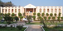
Poonamallee is a town and suburb of Chennai, India under the Chennai Metropolitan Area. It was historically called Pushpagirimangalam, later renamed in Tamil as Poovirundhavalli, and now colloquially called as Poondhamalli. It is the headquarters of the Poonamallee taluk of the Tiruvallur district in the Indian state of Tamil Nadu. The nearest Railway station is at Avadi. It acts as the gateway to the city from its western side. It is a town with rich cultural heritage and also a fast-growing areas in the city. As of 2011, the town had a population of 57,224. There are plans to merge the areas under Poonamallee Municipality with Avadi Municipal Corporation.

Nandambakkam is a western neighbourhood of Chennai, India. It is known for the Chennai Trade Centre and the Surgical Instruments Factory. In 2011 Nandambakkam was included to Chennai district by the Government of Tamil Nadu.

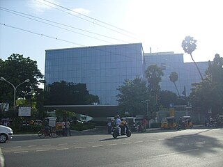
Manapakkam is a neighborhood in Chennai in the Indian state of Tamil Nadu. A census town, Manapakkam is located along the Mount-Poonamallee Road in Chennai. It is now a home to many IT companies, like DLF Cybercity Chennai and Larsen & Toubro. Manappakam has beautiful and scenic Adyar River Bank Trail suitable for morning walkers and joggers, it is a 3-km stretch extended till Chennai Airport's secondary Runway Bridge.
Ramapuram is a neighbourhood in the western part of Chennai, India. It is situated on the Mount-Poonamallee Road at a distance of 3 kilometres from Guindy. Ramapuram forms a part of Maduravoyal taluk, Chennai district. Ramapuram is located at an altitude of 42 m above the mean sea level with the geographical coordinates of 13.010600°N 80.193180°E.
Iyyappanthangal is a neighborhood to the west of Chennai, Tamilnadu, India. It comes under Mangadu Municipality of Chennai Metropolitan Area (CMA), governed by CMDA. It is located 20 kilometres (12 mi) away from Fort St George on the Mount-Poonamallee Road. The nearest railway stations are at Guindy about 11 kilometres (6.8 mi) away and Avadi about 12 kilometres (7.5 mi) away. The Porur Junction where a much-needed road overbridge on the busy Guindy–Poonamallee stretch was built after a very long delay of nearly five years is just about 2 km from Iyyapanthangal and the Poonamallee Junction is just about 6 km from the town.
Mugalivakkam is a neighbourhood of Chennai. It is located in Sriperumbudur taluk of Kanchipuram district, in Tamil Nadu. It is situated 16 km south-west of Chennai on the Mount-Poonamallee Road. It is bounded by Porur on the North Meenambakkam and Manapakkam on the South and South East, Madhanandhapuram and Gerugambakkam on the South West and Ramapuram on the North East directions. The nearest railway station is at Guindy which is about 6 kilometres away. Porur junction is around 2 km away and Kathipara Junction is around 5 km away.
Grand Southern Trunk Road or National Highway 45 is an arterial road in the Indian state of Tamil Nadu. It is also known as Chennai–Trichy-Dindigul-Theni Highway. The road starts from Kathipara Junction in St Thomas Mount, Chennai towards Trichy, Dindigul and Theni. It branches out from Anna Salai.

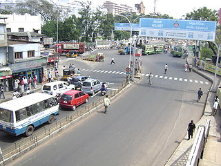
Kathipara Junction is an important road junction in Chennai, India. It is located at Alandur at the intersection of the Grand Southern Trunk Road, Inner Ring Road, Anna Salai and Mount-Poonamallee Road. Kathipara flyover is the largest cloverleaf flyover in South Asia.

Anna Salai, formerly known as St. Thomas Mount Road or simply Mount Road, is an arterial road in Chennai, India. It starts at the Cooum Creek, south of Fort St George, leading in a south-westerly direction towards St. Thomas Mount, and ends at the Kathipara Junction in Guindy. Beyond the Kathipara Junction, a branch road arises traversing westwards to Poonamallee to form the Mount-Poonamallee Road while the main branch continuing southwards to Chennai Airport, Tambaram and beyond to form Grand Southern Trunk Road. Anna Salai, which is more than 400 years old, is acknowledged as the most important road in Chennai city. The head offices of many commercial enterprises and public buildings are located along Anna Salai. It is the second longest road in Chennai, after EVR Periyar Salai.
Chennai High Speed Circular Transportation Corridors (HSCTC) is an urban road transit in the form of elevated concentric beltways planned for the city of Chennai. The beltways are envisaged as an elevated 2-tier system with design speed of 80 km/h. The top tier is a 2-lane dedicated corridor for the Chennai BRTS system. The second tier is a 4-lane road for 4-wheelers (no buses and autos).
Arcot Road(SH-113) is one of the main arterial roads of the city of Chennai in Tamil Nadu, India. The 12-kilometre road connects Nungambakkam with Porur. The road was constructed in the early 1940s and has been responsible for the development of the outlying areas on the western fringes of Chennai city.
Kumananchavadi is a suburb of the city of Chennai in Tamil Nadu, India. It is an upcoming residential suburb located between Iyyapanthangal and Poonamallee on the Mount-Poonamallee Road. Kumananchavadi is situated at a distance of 21 kilometres from Fort St George. The nearest bus stations are at Poonamallee and Iyyapanthangal which are both, two kilometres away while the nearest railway station is at Guindy which is nine kilometres from Kumananchavadi.
Kattupakkam is a suburb of Chennai, in Tiruvallur district, Tamil Nadu, India. It is located in the western side of the city.

Kovilambakkam is a southern suburb of Chennai, India. It is a village panchayat located in Tambaram taluk, Chengalpattu district in the state of Tamil Nadu, about 26 km from Chennai city center and 12 km from Tambaram. The neighbourhood spans the areas of Sunnambu Kolathur, Chinna Kovilambakkam and Periya Kovilambakkam.
EVR Periyar Salai (EVR High Road), earlier known as Poonamallee High Road(NH 48) and originally the Grand Western Trunk Road, is an arterial road in Chennai, India. It is the longest road in Chennai. Running from east to west, the 14-kilometre (8.7 mi) road starts at Muthuswamy Bridge near Madras Medical College at Park Town and ends near Maduravoyal Junction via Kilpauk, Aminjikarai, Anna Nagar Arch, Arumbakkam, Koyambedu. It further continues west towards Poonamallee and traverses the towns of Sriperumbudur, Walajapet, and Ranipet.
Kadambathur, also spelt Kadambattur, is a town located in Tiruvallur district in the Indian state of Tamil Nadu. It is a census town in Tiruvallur taluk. According to the 2011 census, the town has a population of 11,235.
Pallavaram–Kundrathur–Poonamallee Road or State Highway 113A is an arterial road in Chennai City connecting Grand Southern Trunk Road in Pallavaram with Trunk Road in Kumananchavadi in Poonamallee running for a length of 13 kilometres (8.1 mi). The road is also known as Pammal Main Road. The road runs through Pammal, Anakaputhur, Kundrathur, Mangadu and Kumanan Chavadi.