Wall Tax Road, also known officially as V. O. C. Salai, is a road in Chennai, India, adjacent to the Chennai Central railway station. The road runs parallel to the railway tracks of the station and borders George Town on the west. The eastern entrance of the terminus lies on the road.[1] The road is named after the wall built as a protective measure by the British in 1772–1773, which still remains partially.
Plan of Fort St George and the city of Madras in 1726.
After being under the French control for a brief period from 1746 to 1748, the city of Madras was returned to the British following the Treaty of Aix-la-Chapelle.[2][3] Soon after the treaty, the British began planning to strengthen Fort St. George and its protective Esplanade. The attacks by Hyder Ali in 1767 catalysed the process, which resulted in the building of a protective wall around the new Black Town, including the neighbourhoods such as Muthialpettah and Peddunaickenpettah (parts of the present-day George Town), located at the northern and western sides of the Fort.[4] The Black Town Wall, as it was known then, was conceived by the company's chief engineer John Call[5] and completed in 1772 by Paul Benfield,[6] a contractor with the British government bidding about ₹ 500,000. With the Fort to the south and the sea to the east, the wall with 17 bastions ran for about 3.5miles.[5][7] Some of the remnants of the bastions, in which debtors and prisoners were believed to have been confined, are still found along Old Jail Road. The wall also had several gates, including Pully, Boatmen's, Trivatore, Ennore, Elephant, Chuckler's and Hospital gates. However, only one of them, the Elephant Gate, which was then used to load and unload goods transported in trams, remains today.[7] During the 1782 war with Hyder Ali, with the exception of Monegar Choultry, all buildings near the wall were destroyed by the government.[8]
The wall originally ran from Cochrane Canal on the northern side, now known as the Buckingham Canal, to the junction of Poonamalle High Road and Madras Central railway station on the southern side. The outer side of the wall had provisions measuring about 600 yards for setting up a clear field for fire in the event of a future attack,[9][10] which was later developed into People's Park and a railway goods shed named Salt Cotaurs in 1859. A mini-fort with gun emplacements was built at the sea-end side of the wall, and the fort was named Clive Battery, after Edward Clive, governor of Madras from 1799 to 1803, which was later demolished to build a flyover connecting Royapuram and Rajaji Salai.[10] A 50-feet road was built on the inner side of the wall to facilitate connectivity.[7] When the road was completed, the government decided to impose the cost of the newly laid road on the public in the form of tax, but the people refused to pay it. Thus, the tax was never collected.[11] This eventually lead to the road acquiring its name.[7]
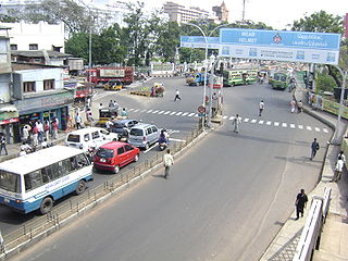
The present-day road
Over the years, the area has been dominated by business community such as Chettiars, Naickers and North Indian community. The road remained the entertainment hub of pre-Independence era. There were three theatres on the road, namely, Otrai Vadai, Empress and Padmanabha. None of these is existent, with the closure of the last one, the Padmanabha theatre, in 2007.[7]
Today, the road remains partly commercial and partly residential. Commercial activities in and around the road include parcel services, hotels and lodges. There are several streets branching from the road and all enjoy similar business activities. Mint Street, which housed mint in the early 19th century, houses the government printing press. The road is also known for its prominence in bamboo products such as baskets, mats and other artefacts, a commercial activity established on the road since Independence. The Andhra Pradesh bus stand, which had been used by buses to Andhra Pradesh before the opening of Chennai Mofussil Bus Terminus, is located opposite to Padmanabha Theatre and has now been converted into a government park. A sardine market, operating since the 1960s, is located at the Old Jail Road junction at the end of the road. However, it has been reduced in size over the years, especially after the closure of the Andhra Pradesh bus terminus.[7]
Walltax Road (now, V.O.C. Salai), which is adjacent to the Central Railway Station, runs parallel to railway tracks and flanks Georgetown on the west. The history of the road dates back to 18th Century. The wall, which one sees partially now, was instituted as a protective measure by the English in 1772–73. The French occupied the City from 1746 to 1749. When British got back the City, it began plans to strengthen the Fort. When Hyder Ali attacked the neighborhoods in 1767, the British made serious plans to protect the New Black Town (Muthialpettah and Peddunaickenpettah) and thus plans for a protective wall was laid out. The wall, called ‘Black Town Wall,' ran for three-and-half-miles and had 17 bastions. It was completed by Paul Benfield in 1772.
The wall ran from Cochrane Canal on north to Poonamalle High Road- Central Station junction on the south. On the outer side of the walls, a vast space of six hundred yards was provided to set up a clear field for fire. In 1859, it was converted into People's Park and Salt Cotaurs. The walls had gates, some of which were Pully Gate, Boatmen's Gate, Trivatore Gate, Ennore Gate, Elephant Gate, Chuckler's Gate and Hospital Gate. Elephant Gate, which remains till today, was then used for loading and unloading of goods carried in trams.
On the other side of the wall, a 50-feet road was built to facilitate connectivity. The cost of which was imposed on the people. People protested to the tax and it was never collected. The Road probably acquired the name from these instances. It is said that the debtor and prisoners were confined in the bastions, some of the remnants of which was still found on the Old Jail Road.
This historically significant Road is now besieged by commercial activities housing parcel services, lodges, hotels and the branching streets bristling with business. Yet, it has some of the remains intact and significant streets serving new purposes.
The Mint Street, one of the most happening places in Georgetown, housed Mint in early years of 19th Century. The unit which was used to produce gunpowder was transformed into a Mint for which the work began in 1804. The building was completed in 1807, but the mint machineries were made available only in 1841. Now, the building is converted into Government printing press and is being used for the print requirements of the Government.
After the Sepoy Mutiny, The British offered thanksgiving to God by building Memorial Hall in South Mint Street in 1860.
Georgetown has the pride of having seen the first of the earlier temples of the City.
Kandaswamy Temple was built in 1670 by Beri Chettiars on Rasappa Chetty Street. (There is also a record saying that the temple belonged to the 11{+t} {+h} Century). The temple is dedicated to Lord Siva and bears some rich inscriptions of the era. The shrines contained in the temple are those of Kadaswamy, Siva, Vishnu and Brahma. It is said that social reformer Ramalinga Adigalar sang ‘Deivamanimalai' in this temple. In 1930, a grand Kumbabhishekam was held after which it became an annual affair drawing lot of crowd.
One cannot but miss the sight of bamboo vendors on Walltax Road who make bamboo mats, baskets and other artefacts on the platform. They have been doing business in Georgetown for more than 60 years. The fourth generation vendors were shifted from Flower Bazaar 40 years ago to Walltax Road. Recently, they have been asked to vacate from Walltax Road by the Chennai Corporation as a measure to remove encroachment.
The Andhra Pradesh Bus Stand located diagonally opposite to Padmanabha Theatre is now turned into Walltax Road Depot. Buses used to ply Andhra Pradesh until the coming of CMBT.
The Sardine Market, more than 50- years-old, located at the end of Walltax Road and the Old Jail Road junction, has been reduced in size over the years. After the closure of Andhra Pradesh Bus Stand, the market is seeing a slow business and the vendors have shifted to Koyembedu.
As was mentioned in the previous article, Walltax Road was the entertainment hub of those years. Out of the three theatres, Otrai Vadai, Empress and Padmanabha, the later remained intact until recently. It was closed five years ago. Walltax Road is partly residential and partly commercial. The area has been dominated by business community such as Chettiars, Naickers and North Indian community. The branching streets are doing brisk business in various products. It is said that in earlier days, Chettiars used to sell gold kept in heaps on the road on Mint Street. Now the street sells almost all products. Elephant Gate Street specialises in dress materials, Nainiappan Naicken Street in jewellery, Kasi Chetty Street and Narayana Mudali Street in electronics goods, toys and other foreign goods and Rasappa Chetty in hardware.
The Buckingham Canal is a 796 kilometres (494.6 mi)-long fresh water navigation canal, that parallels the Coromandel Coast of South India from Kakinada City in the Kakinada district of Andhra Pradesh to Parangipettai near Chidambaram, Cuddalore District of Tamil Nadu, India. The canal connects most of the natural backwaters along the coast to Chennai (Madras) port.
Thyagaraya Nagar, commonly known as T. Nagar, and historically known as East Mambalam, is a very affluent commercial and residential neighbourhood in Chennai, Tamil Nadu, India. It is surrounded by Nungambakkam in the North, Teynampet in the East, Nandanam in the South-East, C.I.T. Nagar in the South and West Mambalam and Kodambakkam in the West. The stretch between Duraiswamy Road and T. Nagar Bus Stand has some of the costliest real estates in Chennai. It was constructed between 1923 and 1925 by the Madras Presidency government of the Raja of Panagal as a part of town planning activities initiated according to the Madras Town Planning Act of 1920. The town was named after P. Thyagaraya Chetty. The streets, parks and localities in the new neighbourhood were named after important officials in the provincial government.
Chennai, formerly known as Madras, is the capital of the state of Tamil Nadu and is India's fifth largest city. It is located on the Coromandel Coast of the Bay of Bengal. With an estimated population of 12.05 million (2024), the 383-year-old city is the 31st largest metropolitan area in the world.
Gooty is a town in Anantapur district of the Indian state of Andhra Pradesh. It is the headquarters of Gooty mandal in Anantapur revenue division. The town is renowned for the Gooty hill fort.
Chennai architecture is a confluence of many architectural styles. From ancient Tamil temples built by the Pallavas, to the Indo-Saracenic style of the colonial era, to 20th-century steel and chrome of skyscrapers. Chennai has a colonial core in the port area, surrounded by progressively newer areas as one travels away from the port, punctuated with old temples, churches and mosques.
Kadapa is a city in the southern part of Andhra Pradesh, India. It is located in the Rayalaseema region, and is the district headquarters of YSR Kadapa district. As of the 2022 Census of India, the city had a population of 466,000, a 2.42% increase from 2021. It is located 8 kilometres (5.0 mi) south of the Penna River. The city is surrounded on three sides by the Nallamala and Palkonda Hills lying on the tectonic landscape between the Eastern and Western ghats. Black and red ferrous soils occupy the region. The city is nicknamed "Gadapa" ('threshold') since it is the gateway from the west to the hills of Tirumala.
Tiruttani is a historic temple town situated in the Tiruvallur district and serves as a suburb of Chennai within the Chennai Metropolitan Area in the southern Indian state of Tamil Nadu. The town is famous for the Tiruttani Murugan Temple, an ancient Hindu temple dedicated to Kartikeya, also known as Murugan, the Hindu god of war. This temple is one of the Arupadaiveedu, a group of six significant abodes of Murugan. Tiruttani was officially incorporated into the Chennai Metropolitan Area in October 2022, signifying its growing importance and influence within the region..
Vannarapettai (transl. Washermenpet) is a northern neighbourhood of Chennai, India. It is also known as Pazhaya Vannarapettai, sometimes shortened as Vannai. It is located north of Parrys Corner and adjacent to Royapuram. Washermanpet is famous for its jewelry shops and matchbox industries, many of which are centered on two main arterial roads.
Krishnagiri is a city in the state of Tamil Nadu, India, and it serves as the administrative headquarters of Krishnagiri District formed in 2004. It is located at the bottom of Krishnadevaraya Hills, and the town is fully surrounded by hill rocks. It is located 250 km from Chennai, 45 km from Dharmapuri, and 90 km from Bengaluru. Krishnagiri is known as "Mango Capital of India" as mangoes are cultivated as the main crop, and the land here is extremely fertile with rich access to fresh water making it amenable to growing crops. Krishnagiri is the site of significant business and residential development. The Krishnagiri Dam was built in 1967.
Muhammad Ali Khan Wallajah, or Muhammed Ali, Wallajah, was the Nawab of the Carnatic from 1749 until his death in 1795. He declared himself Nawab in 1749. This position was disputed between Wallajah and Chanda Sahib. In 1752, after several clashes, Chanda Sahib's forces and his French allies were expelled from Arcot, officially declaring Wallajah as Nawab on 26 August 1765. His reign was recognised by Mughal emperor Shah Alam II.
The Kālikāmbal Temple is a Hindu temple dedicated to Shri Kāligāmbāl (Kāmākshi) and Lord Kamadeswarar, located in Parry's corner locality of the city of Chennai, Tamil Nadu, India. The temple is located in Thambu Chetty Street, a prominent financial street at Georgetown, running parallel to Rajaji Salai.
Anna Salai, formerly known as St. Thomas Mount Road or simply Mount Road, is an arterial road in Chennai, India. It starts at the Cooum Creek, south of Fort St George, leading in a south-westerly direction towards St. Thomas Mount, and ends at the Kathipara Junction in Guindy. Beyond the Kathipara Junction, a branch road arises traversing westwards to Poonamallee to form the Mount-Poonamallee Road while the main branch continuing southwards to Chennai Airport, Tambaram and beyond to form Grand Southern Trunk Road. Anna Salai, which is more than 400 years old, is acknowledged as the most important road in Chennai city. The head offices of many commercial enterprises and public buildings are located along Anna Salai. It is the second longest road in Chennai, after EVR Periyar Salai.
George Town is a neighbourhood in Chennai, Tamil Nadu, India. It is near the Fort Saint George, Chennai. It is also known as Muthialpet and Parry's corner. It is an historical area of Madras city from where its expansion began in the 1640s. It extends from the Bay of Bengal in the east to Park town on the west. The Fort St. George is on the south, to Royapuram in the north. The Fort St. George houses the Tamil Nadu Legislative Assembly and the Secretariat. The High court of Tamil Nadu at Chennai, Dr. Ambedkar Law College, Stanley Medical College and Hospital are located here.
Gazulu Lakshminarasu ChettyCSI was an Indian merchant and political activist who founded the Madras Native Association, one of the earliest Indian political associations, and the first Indian-owned newspaper in Madras, The Crescent. He was also the second Indian to be appointed a member of the Madras Legislative Council, succeeding V. Sadagopacharlu on his death. Lakshminarasu Chetty was born in 1806 to a wealthy indigo merchant Sidhulu Chetty in Madras. On completion of his initial education, Chetty entered the family trade and succeeded as a businessman. He entered politics and devoted money for social and philanthropic causes.
China Bazaar Road, officially Netaji Subash Chandra Bose Road, is one of the main thoroughfares of the commercial centre of George Town in Chennai, India. The road connects Rajaji Salai in the east and Wall Tax Road in the west. Passing through thickly populated residential areas of the historical neighbourhood, the road has several streets, lanes, and by lanes joining it, housing several commercial establishments of the city.
EVR Periyar Salai (EVR High Road), earlier known as Poonamallee High Road(NH 48) and originally the Grand Western Trunk Road, is an arterial road in Chennai, India. It is the longest road in Chennai. Running from east to west, the 14-kilometre (8.7 mi) road starts at Muthuswamy Bridge near Madras Medical College at Park Town and ends near Maduravoyal Junction via Kilpauk, Aminjikarai, Anna Nagar Arch, Arumbakkam, Koyambedu. It further continues west towards Poonamallee and traverses the towns of Sriperumbudur, Walajapet, and Ranipet.
Peravallur is a developed residential area, located on the north - western corner of Madras, a metropolitan city in Tamil Nadu state, India. Out of 1018 places to be renamed by the government of Tamil Nadu, Peravallur is the one to be renamed as "Peravalloor". CMDA is the town planning agency for Peravallur. Official language is Tamil; Postal pincode is 600082; Greater Chennai Corporation is the Civic body. A police station viz., K - 5 Peravallur Police Station for this neighborhood is built a year ago with ample space, at the junction of Venkatesan Salai and Siva Elango Salai in Jawahar Nagar near Perambur.
Mint Street is one of the prime streets of the commercial centre of George Town in Chennai, India. The street is one of the oldest streets in Chennai and is believed to be the longest street in the city. Running north–south, the street connects Poonamallee High Road at Park Town in the south with North Wall Road–Old Jail Road Junction at Washermanpet in the north. Running parallel to the Wall Tax Road, another historical thoroughfare in the city, the street passes through thickly populated residential and commercial areas of the historical neighbourhood.
Old Jail Road is one of the peripheral roads that border the historical neighbourhood and commercial centre of George Town in Chennai, India. The road marks the northern boundary of the neighbourhood and is officially divided into three, namely, from west to east, the Basin Bridge Road, the Old Jail Road, and the Ibrahim Sahib Street. The road joins the Grand Northern Trunk (GNT) Road at the Wall Tax Road–GNT Road junction in the west and the Rajaji Salai in the east.
Thiru Vi Ka Salai, or the Thiru Vi Ka High Road, is one of the main streets in the downtown region of Chennai, Tamil Nadu, India. Running from north to south, the street branches off of the arterial Anna Salai north of the LIC Building and ends at Luz Corner in Mylapore, continuing as the Ramakrishna Mutt Road. The street connects the neighbourhoods of Royapettah, Mylapore and Gopalapuram. The street includes three individual stretches formerly known as General Patters Road, Westcott Road and Royapettah High Road, respectively. The longest stretch, formerly known as the Royapettah High Road, runs to a length of 1.17 km (0.73 mi). The presence of numerous automobile dealers on the northern end of the street resulted in Chennai coming to be known as The Detroit of India.
↑ Sosin, Jack M., "Louisburg and the Peace of Aix-la-Chapelle, 1748," The William and Mary Quarterly. Third Series, Vol. 14, No. 4 (October 1957): 516–535
This page is based on this Wikipedia article Text is available under the CC BY-SA 4.0 license; additional terms may apply. Images, videos and audio are available under their respective licenses.