
Doda district is an administrative district of the Jammu division of Indian-administered Jammu and Kashmir in the disputed Kashmir region.

Bhaderwah or Bhadarwah or "Chota Kashmir" is a town, tehsil, sub-division and also additional district in the Doda district of the Jammu Division of Jammu and Kashmir, India. It is also known as Bhadrakashi. The ancient name of Bhaderwah is Bhadravakasa as mentioned in Kalhana's Rajatarangini. For its high literacy rate it is known as Kerala of Jammu and Kashmir.
Ramban district is an administrative district in the Jammu division of Indian-administered Jammu and Kashmir in the disputed Kashmir region. It is located in a valley surrounded the Pir Panjal range. It was carved out as a separate district from erstwhile Doda district in 2007. It is located in the Jammu division. The district headquarters are at Ramban town, which is located midway between Jammu and Srinagar along the Chenab river in the Chenab valley on National Highway-44, approximately 151 km from Jammu and Srinagar.

Kishtwar district is an administrative district of the Jammu division of Indian-administered Jammu and Kashmir in the disputed Kashmir region. As of 2011, it is the largest and the least populous district of Jammu and Kashmir.

The Chenab Valley is a river valley formed by the Chenab River. The term is also used collectively for Doda, Kishtwar and Ramban districts of Jammu Division in the Indian-administered Jammu and Kashmir. These districts were formerly part of a single district, called Doda.
Gandoh is a tehsil in district Doda of the Indian union territory of Jammu and Kashmir. The village is located on Thathri-Gandoh National Highway.

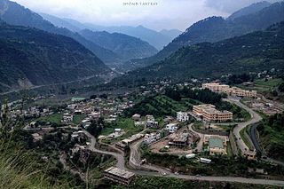
Thathri is a town and a notified area committee in Doda district in the Indian union territory of Jammu and Kashmir. Thathri valley is located in the foothills of the Himalayan mountains, about 85 km from Batote. Apart from having ample forests, the town contains many small streams flowing through its various parts. It is located on the banks of the Chenab River and the town area is spread over 1.50 sq. Km².

Jantroon Dhar or Jantroon Top is a location in the Doda district, in Jammu and Kashmir, India. It is a local hill station and a meadow in the Forest Block area, 15 kilometers away from Thathri. The place is surrounded by lush green meadows, snow in winters and covered with dense vegetation. Thousands of local tourists visit every year for spectating three days dangal-cum-wrestling match.
Chiralla is an Indian village and a tehsil in Doda district of Jammu and Kashmir. It was formerly part of Thathri tehsil and block. This tehsil have 9 Panchayats including Bhallara, Chagsoo, Jagota, Chiralla, Panshei, Puneja, Rokali, Sunarthawa and Thallela.

Bhalessa is a geographical area within Doda district in the Jammu region of India-administered Kashmir. It consists of the Bunjwah and Bhalessa Valleys, and comprises the three Tehsils of Kahara, Chilly Pingal and Gandoh.

Kahara is a village and tehsil in Doda district, Jammu, India. It is situated between mountainous cliffs 13 kilometres (8.1 mi) from Thathri on the Thathri-Gandoh road.
Bunjwah is a region and tehsil located in the Kishtwar district of Jammu and Kashmir, India. It comprises nine panchayat and two nayabats; it became a tehsil in 2014.
Phagsoo is a village and tehsil in the Doda district of the Jammu division of Jammu and Kashmir, India. It was previously part of the Thathri tehsil.
Badanoo is a village in Thathri tehsil of Doda district in Jammu and Kashmir. It is located at least 36 kilometres from its district headquarters. This village is the part of Patwar Halqa Jangalwar.
Jangalwar is a village and panchayat in the Thathri tehsil of Doda district in the Jammu division of Jammu and Kashmir, India.
Bhella is a tehsil in the Doda district of Jammu and Kashmir. It was previously part of the Thathri tehsil. In 2022, Bhella became the part of Bhaderwah Assembly constituency.
Shibnote is a village in Thathri sub-division of Doda district in Jammu and Kashmir.
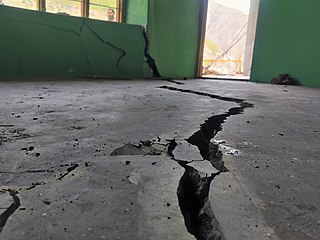
On 1 February 2023, a land subsidence event developed in the town of Thathri in the Doda district of Jammu and Kashmir, India, resulting in 23 structures being declared unsafe and approximately 300 people being displaced. The event has been described by geological experts as a multifactor landsliding. Buildings impacted include several houses, a mosque, a religious school for girls, and a cricket academy. As of 9 February 2023, a massive landsliding was reported at Nayi Basti which blocked National Highway 244 for hours. As of 23 March 2023, the incident spot is declared as "not habitable" by Geological Survey of India report.
Halaran is a village and panchayat located in the Kahara tehsil of Doda district in the Indian administered union territory of Jammu and Kashmir. The village is situated approximately 13 kilometers away from the sub-divisional headquarters, Thathri, and 43 kilometers away from the district headquarters, Doda.
