Main Street (Greater Salt Lake City)

Last updated
Main Street in Salt Lake City, early 20th Century Main Street, Salt Lake City, Utah (NYPL b12647398-73982).tiff
Main Street in Salt Lake City, early 20th Century

Main Street is the most important commercial street in Salt Lake City, Utah, United States though it also extends south into the cities of South Salt Lake, Millcreek, and Murray. Its commercial importance is almost totally derived from the few blocks of the street which are immediately south of Temple Square that have attracted banks, major retailers, and heavy foot traffic throughout Salt Lake City's history; the long southern extension of Main Street south of about 500 and 600 South, in contrast, is always in the shadow of State Street (one block to the east), which (due to width, speed limit, and restraint of cross traffic) is more designed for the long-distance automobile traffic that is common away from downtown.

Contents

Route description

Murray

Main Street begins in Murray at a four-way intersection with 4500 South and Auto Boulevard. Auto Boulevard is effectively a southern continuation of Main Street, though it immediately begins a curve to the east and intersects with State Street. Main Street is proposed to be extended a short distance south of this intersection (displacing the north end of Auto Boulevard) before splitting into a new one-way pair in which car traffic will be routed southward on Box Elder Street via a new connecting road and will be directed onto Main Street from the south via Hanaur Street. [1]

North of its current terminus, Main Street leads through a former industrial area that is being redeveloped as transit oriented development associated with the Murray North TRAX station before leaving Murray on a bridge over Big Cottonwood Creek just a few blocks from the terminus.

Millcreek

The segment of Main Street within Millcreek is also just a few blocks because it passes through the narrow western end of the city. The area is mostly used for industrial and wholesale purposes.

South Salt Lake

The south end of South Salt Lake's portion of Main Street passes a park and small retail and office developments before the surroundings revert to industrial- or wholesale-related businesses. North of 3300 South, the mixture of frontage becomes more varied, with retail, office and residential buildings mixed in with industrial and wholesale ones. Main Street crosses Mill Creek at about 3000 South, and a UTA-owned abandoned railroad spur runs along the south side of the creek between Main Street at the TRAX Red and Blue Lines' route at 200 West. The Street continues north through areas with a similar mix of land uses, but also passes the South Salt Lake Police Department headquarters at Sunset Avenue and a Granite School District elementary school plus administrative building housed in a former hospital at 2500 South before passing under Interstate 80, crossing the S Line (formerly known as Sugar House Streetcar) right-of-way, and entering Salt Lake City at 2100 South. Main Street is a four lane road (with or without a center turn lane) throughout South Salt Lake and has sidewalks almost everywhere. Main Street north of 3300 South in South Salt Lake was Utah State Route 202 from 1961 to 1967.

Southern Salt Lake City

Soon after entering Salt Lake City, Main Street (which is three to four lanes wide with full bicycle lanes as well south of downtown) passes the sprawling O. C. Tanner headquarters before passing small residential, retail, and office developments south of 1300 South. Near 1300 South, the street also passes Smith's Ballpark and Horizonte High School. North of 1300 South, larger-scale retail developments and some remnant industrial uses become more dominant. TRAX light rail tracks enter the median of Main Street from 700 South and continue downtown.

Downtown Salt Lake City

222 Main building in Salt Lake City 222 South Main Street in Salt Lake City, Utah.jpg
222 Main building in Salt Lake City

In downtown, Main Street consists of wide sidewalks on both sides, TRAX light rail tracks (and electrification poles) in the middle, one narrow lane in each direction with Shared lane markings (sharrows) on continuous green painted strips to encourage use by bicycles, and intermittent on-street parking and delivery-only areas. The wide sidewalks are broken up in some places by outdoor restaurant seating and landscaping elements, including many mature trees. There is only one driveway fronting onto Main Street between 400 South and South Temple. Some of the many notable and historic buildings on Main Street downtown are (from south to north):

Main Street Plaza

The Church of Jesus Christ of Latter-day Saints-owned Main Street pedestrian plaza extends for one block along the east side of Temple Square. The Salt Lake Temple and the Joseph Smith Memorial Building face directly onto the plaza. The monument marking the origin of the address system and the Salt Lake Meridian is at the southwest corner of the plaza, next to the Brigham Young Monument.

North end

Main Street continues north of the pedestrian plaza, starting at an intersection with North Temple and the steep driveway leading down to underground parking beneath the pedestrianized section. It immediately starts climbing Capitol Hill and passes the LDS Conference Center and Alfred McCune Home before reaching a five-way intersection with 300 North and Columbus Street at the southwest corner of the Utah State Capitol Building's grounds. Utah State Route 186 turns from 300 North to Columbus Street at this intersection, while city-maintained 300 North continues west and Main Street continues north but veers slightly westward, losing its alignment with the Salt Lake Meridian. A lot of traffic from the south turns onto Columbus Street (which is at a very acute angle to the northern continuation of Main Street) instead of continuing on Main Street here since State Route 186 provides a through route to the north on Victory Road without sharp turns or steep grades. Main Street, in contrast, continues north-northwest through residential areas to descend a steep hill and end at Girard Avenue (560 North), where traffic heading north must turn west to reach 200 West or 300 West (US-89). Overall in its northernmost two and a half blocks, Main Street moves 110 address units west.

Other Segments

A detached segment of Main Street also exists running from 5900 South to 6100 South (and beyond, in the form of a parking lot associated with the Murray Heritage Center, to Creek Drive) in southern Murray; the name Main Street was applied to it due to its alignment with the Salt Lake Meridian, but without a connection to the main segment of Main Street. Moreover, in Midvale, just south of Murray, 700 West is also known as Main Street, despite its not being aligned with the Salt Lake Meridian, and several unrelated historic streets elsewhere in Salt Lake County are also called Main Street despite the county having a mostly-unified addressing system. For example, there is a Main Street in Magna, though it follows 2700 South in the Salt Lake County scheme.

Light rail

Main Street in downtown Salt Lake City looking south 2012.10.01.172700 Tram S Main Street Salt Lake City Utah.jpg
Main Street in downtown Salt Lake City looking south

TRAX light rail has run in the median of Main Street from 700 South to South Temple since 1999, recapitulating streetcars that previously connected Main Street to the rest of downtown, to other neighborhoods, and to a few further-out destinations. South of 700 South, the modern TRAX system instead uses the former Salt Lake and Utah and Union Pacific lines running two blocks west of Main Street, so the trains can attain high speeds in their dedicated corridor while never being far from Main Street. The Red Line branches off of the main north–south line at a half grand union at 400 South Main Street and heads toward University of Utah. The three stations in the median of Main Street downtown are Courthouse (on the north side of 500 South), Gallivan Plaza (on the north side of 300 South), and City Center (on the north side of 100 South).

Addressing

Except on Capitol Hill, Main Street runs along the north–south axis of the Salt Lake County addressing system (essentially the Salt Lake Meridian), so addresses east of Main Street include the word East and addresses west of Main Street include the word West unless the address is along a north–south street that, like Main Street, has an official non-numeric name (see Salt Lake County addressing system). On Capitol Hill, there are some addresses that are numbered as west of the Meridian even though they are east of Main Street; this is due to Main Street's turn to the northwest at 300 North, while the north–south numbering split follows Columbus Street north of this intersection.

South of South Temple (the system's east–west axis), buildings on the east side get odd-numbered addresses and buildings on the west side get even-numbered addresses, while north of South Temple, this is reversed.

History

Main Street was originally known as East Temple because it ran along the east side of the temple block.[ citation needed ] West Temple (including Utah State Route 270) retains its analogous name, as do the east–west streets South Temple and North Temple. Notable structures that previously existed on Main Street include:

Related Research Articles

<span class="mw-page-title-main">Buildings and sites of Salt Lake City</span>

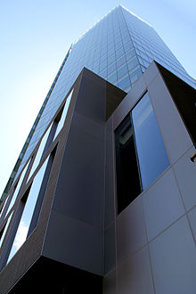
Salt Lake City, Utah has many historic and notable sites within its immediate borders. Although the entire Salt Lake City metropolitan area is often referred to as "Salt Lake City", this article is concerned only with the buildings and sites within the official city limits of Salt Lake City.

<span class="mw-page-title-main">Downtown Salt Lake City</span>

Downtown is the oldest district in Salt Lake City, Utah, United States. The grid from which the entire city is laid out originates at Temple Square, the location of the Salt Lake Temple.

<span class="mw-page-title-main">Transportation in Salt Lake City</span>

Transportation in Salt Lake City consists of a wide network of roads, an extensive bus system, a light rail system, and a commuter rail line. Although Salt Lake City, Utah, is a traditionally car-oriented city, the rapidly growing public transit system has a high number of riders for a city of its size, and public transit is widely supported by its residents and businesses.

<span class="mw-page-title-main">Blue Line (TRAX)</span> Light rail line in Salt Lake City, Utah, USA

The Blue Line is a light rail line on the TRAX system in the Salt Lake Valley of Utah, in the United States, operated by the Utah Transit Authority (UTA). It is the first line of the TRAX system completed. The line opened on December 4, 1999, one year ahead of schedule after two years of construction. In addition to Salt Lake City, it also serves the communities of South Salt Lake, Murray, Midvale, Sandy and Draper. The line was known as the North/South Line or the Sandy/Salt Lake Line until color names were adopted for each TRAX line in August 2011. An extension of the line to Draper began service on August 18, 2013.

<span class="mw-page-title-main">University Line (TRAX)</span>

The University Line is an obsolete designation to a light rail line of Utah Transit Authority's (UTA) TRAX system in Salt Lake City. It was the second TRAX line opened by UTA, after the Sandy/Salt Lake Line opened in 1999. The original line ran from the Delta Center Station to the Stadium Station, which is west of the Rice-Eccles Stadium on the University of Utah campus. The eastern end of the line was extended to the University Medical Center Station in 2003, and the western end was extended in 2008 to the new Salt Lake City Intermodal Hub. The University Line continued running under that name through August 6, 2011, after which this designation was no longer used following a system redesign. The University of Utah is now served by the Red Line.

<span class="mw-page-title-main">Utah State Route 186</span> State highway in Utah, United States

State Route 186 (SR-186) is a state highway entirely within Salt Lake City, capital of the U.S. state of Utah. It forms a quarter-beltway connecting US-89 and I-15 leading north from Salt Lake City to I-80 leading east; as such, it effectively forms the missing (non-freeway) quarter of the I-215 belt route around the city, though it does not directly connect to I-215 at the north end. Despite this beltway role, the route passes through downtown Salt Lake City because downtown is built right up to the northern mountains surrounding City Creek Canyon. The portion of the route connecting downtown to I-80 is a high-capacity street heavily used by commuters, especially those travelling to the University of Utah or between downtown and eastern neighborhoods, but the portion on Capitol Hill north of downtown is much narrower and has sharp turns around the Capitol grounds. The roadway runs 9.34 miles (15.03 km) along Victory Road, Columbus Street, 300 North, State Street, 400 South, 500 South, and Foothill Drive.

<span class="mw-page-title-main">Utah State Route 71</span> State highway in Utah, United States

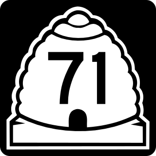
State Route 71 (SR-71) is a state highway completely within the Salt Lake City metropolitan area in the northern portion of the US state of Utah. It runs from SR-154 in the southwest side of the city to SR-186 in Downtown Salt Lake City. The route spans 22.47 miles (36.16 km) as it runs along portions of 12600 South, 12300 South, 900 East, and 700 East streets.

<span class="mw-page-title-main">City Creek Center</span> Shopping mall in Salt Lake City, Utah, U.S.

The City Creek Center (CCC) is a mixed-use development with an upscale open-air shopping center, office and residential buildings, fountain, and simulated creek near Temple Square in downtown Salt Lake City, Utah, United States. It is an undertaking by Property Reserve, Inc. (PRI), the commercial real estate division of the Corporation of the President of The Church of Jesus Christ of Latter-day Saints and Taubman Centers, Inc. (TCI). The CCC integrates shopping and residential elements, with foliage-lined walkways and streams covering two blocks in the heart of downtown Salt Lake. PRI invested in the housing and parking elements of the mall, while TCI owns and operates the shopping center itself. The CCC opened to the general public on March 22, 2012. This shopping, office, and residential center encompass nearly 20 acres (8.1 ha) of downtown Salt Lake City. The City Creek Center is part of an estimated $5 billion sustainable design project to revitalize downtown Salt Lake City. The CCC project itself has been estimated to cost around $1.5 billion.

<span class="mw-page-title-main">Utah State Route 269</span> State highway in Utah, United States

State Route 269 (SR-269) is a state highway in the U.S. state of Utah that sits completely within Salt Lake City in Salt Lake County. It consists entirely of a one-way pair of 500 South and 600 South, two parallel one-way streets that connect I-15 and I-80 to downtown Salt Lake City. SR-269 was designated in 1960 and constructed later that decade, coinciding with the construction of I-15 in the area.

<span class="mw-page-title-main">Salt Lake City Intermodal Hub</span> Intermodal transit center in Utah, USA

The Salt Lake City Intermodal Hub is a multi-modal transportation hub in Salt Lake City, Utah, United States served by the Blue Line of UTA's TRAX light rail system that operates in Salt Lake County and by the FrontRunner, UTA's commuter rail train that operates along the Wasatch Front with service from Ogden in central Weber County through Davis County, Salt Lake City, and Salt Lake County to Provo in central Utah County. Service at the intermodal hub is also provided by Amtrak, and Greyhound Lines, as well as UTA local bus service.

<span class="mw-page-title-main">Red Line (TRAX)</span> Light rail line in Salt Lake City, Utah, USA

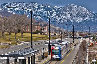
The Red Line is a light rail line on the TRAX system in the Salt Lake Valley of Utah operated by the Utah Transit Authority (UTA). It originally began operation in December 2001 as the peak-hour-only Sandy/University Line, running from the University of Utah south to Sandy Civic Center on the Blue Line. It was later rerouted to South Jordan and renamed the Red Line in August 2011, running as an all-day route. The current line runs from the University of Utah Medical Center in Salt Lake City through the south end of Downtown Salt Lake City, South Salt Lake, Murray, Midvale, West Jordan, and South Jordan to the University of Utah's South Jordan Medical Center in Daybreak.

<span class="mw-page-title-main">City Center station (UTA)</span> Light rail station in Salt Lake City, Utah, US

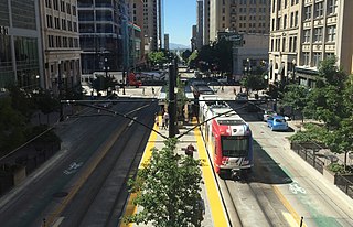
City Center station is a light rail station in Downtown Salt Lake City, Utah, in the United States, served by the Blue Line and Green Line of the Utah Transit Authority's (UTA) TRAX system. The Blue Line has service from the Salt Lake Intermodal Hub in Downtown Salt Lake City to Draper. The Green Line provides service from the Salt Lake City International Airport to West Valley City.

<span class="mw-page-title-main">Green Line (TRAX)</span> Light rail line in Salt Lake City, Utah, US

The Green Line is a light rail line on the Utah Transit Authority's (UTA) TRAX system in Salt Lake City, Utah, in the United States, operated by the Utah Transit Authority (UTA). It opened on August 7, 2011, and runs between Airport Station at the Salt Lake City International Airport and West Valley Central Station in West Valley City serving a total of eighteen stations: thirteen in Salt Lake City, one in South Salt Lake, and four in West Valley City.

<span class="mw-page-title-main">Utah State Route 181 (1935–2007)</span> Former state highway in Utah, United States

State Route 181 (SR-181) was a state highway in the U.S. state of Utah connecting SR-152 in Murray and Holladay north to SR-186 in Salt Lake City at its peak, the former being suburbs of the latter. The route was 6.9 miles (11.10 km) for thirty-eight years before being truncated in 2007 and decommissioned entirely later in the same year.

<span class="mw-page-title-main">S Line (Utah Transit Authority)</span> Streetcar line in Salt Lake County, Utah, United States

The S Line, or S-Line, is a public transit streetcar line in northeastern Salt Lake County, Utah, in the United States, that connects the business district of the Sugar House neighborhood of Salt Lake City with the neighboring city of South Salt Lake, as well as the Utah Transit Authority's (UTA) TRAX light rail system. It is a joint project between UTA, Salt Lake City, and South Salt Lake. It opened for service on December 8, 2013. It is operated by UTA and is UTA's first streetcar line.

State Street is a wide 17.3-mile-long (27.8 km) street in Salt Lake County, Utah leading almost straight south from the steps of the Utah State Capitol Building, through Salt Lake City, South Salt Lake, Millcreek, Murray, eastern Midvale, Sandy, and northwestern Draper. Because it follows the most direct route from downtown Salt Lake City to the Point of the Mountain pass to Utah County, it was the undisputed main road south from Salt Lake City until Interstate 15 (I-15) was built to the west. It retains the U.S. Highway 89 designation for all but the northernmost seven blocks despite I-15's proximity. Due to its history as a route for long-distance travel, travel within the Wasatch Front region, and travel between the cities along the east side of the Jordan River, it has attracted a wide variety of retail and service businesses along its entire length, creating a nearly continuous commercial axis for the Salt Lake Valley.

<span class="mw-page-title-main">Utah State Route 176 (1933–1969)</span> Former state highway in Utah, United States

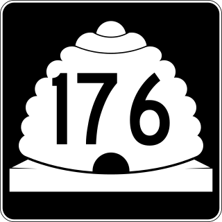
Utah State Route 176 was a state highway in entirely within the cities of Salt Lake City and South Salt Lake in Salt Lake County, Utah, United States. It mainly functioned as an alternate route for US-89, US-91, and I-15 traffic that provided access to industrial areas of the two cities and avoided urban cross-traffic in Downtown Salt Lake City. The original route followed 900 South west from State Street to 300 West and then traveled north on 300 West to meet US-89 and US-91 again at South Temple. The route was subsequently changed to follow 300 West only: it followed 300 West all the way from 3300 South (SR-171) to North Temple.

<span class="mw-page-title-main">Utah Valley Express</span> Bus rapid transit line in Utah County, Utah, US

Utah Valley Express, also known as UVX, is a bus rapid transit (BRT) line in central Utah County, Utah, United States. The line is operated by the Utah Transit Authority (UTA) and runs between southwest Orem to south central Provo by way of Utah Valley University (UVU) and Brigham Young University (BYU). It began service with a soft opening on August 13, 2018 while the station platforms were being finished and was formally opened on January 9, 2019. It is the second of several BRT lines that UTA has or is planning in Utah County and the Salt Lake Valley.

The Midvalley Connector is a planned bus rapid transit (BRT) line anticipated to run between Murray and West Valley City in Utah, United States, that will be operated by the Utah Transit Authority (UTA). It will connect the main campus of Salt Lake Community College (SLCC) in Taylorsville with both the TRAX light rail system and the FrontRunner commuter rail. It is the fourth of several BRT lines that UTA is planning in Utah County and the Salt Lake Valley. Bus Rapid Transit is described by UTA as "light rail on rubber tires".

<span class="mw-page-title-main">Utah State Route 184 (1963–2007)</span> Former state highway in Utah, United States

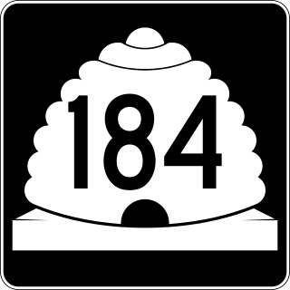
State Route 184 was a state highway in the U.S. state of Utah. It was a 1.9-mile (3.1 km) loop that connected U.S. Route 89 (US-89) in Salt Lake City with the Utah State Capitol. The route was originally added to the state highway system in 1935 as part of SR-181, and SR-184 was created in 1963 as a split from that route. It would remain until 2007, when it was deleted in a series of highway realignments in the Salt Lake City area. However, its route remains on the state highway system as SR-186.

References

  1. "Cottonwood Street Environmental Assessment: We have identified the preferred roadway" (PDF). 6 May 2011.[ dead link ]

Commons-logo.svg Media related to Main Street (Greater Salt Lake City) at Wikimedia Commons