Grand union

Last updated
Track arrangement of a street railway Grand Union Grand union diagram.svg
Track arrangement of a street railway Grand Union
Grand unions
Full grand union
BSicon vCONTgfa.svg
BSicon kvSTR-c2.svg
BSicon kvSTR2.svg
BSicon kvSTR3.svg
BSicon uvSTR.svg
BSicon kvSTR-c3.svg
BSicon vCONTgfaq.svg
BSicon kvSTR2+r.svg
BSicon kvSTRr+1.svg
BSicon uvSTRq.svg
BSicon kvSTRc1.svg
BSicon kvSTRc2.svg
BSicon kvSTRc3.svg
BSicon kvSTRc4.svg
BSicon uvKRZv.svg
BSicon kvSTR3+l.svg
BSicon kvSTRl+4.svg
BSicon uvSTRq.svg
BSicon vCONTgfeq.svg
BSicon kvSTR-c1.svg
BSicon kvSTR+1.svg
BSicon kvSTR+4.svg
BSicon uvSTR.svg
BSicon kvSTR-c4.svg
BSicon vCONTgfe.svg
Three-quarter union
BSicon vCONTgfa.svg
BSicon kvSTR2.svg
BSicon uvSTR.svg
BSicon kvSTR-c3.svg
BSicon vCONTgfaq.svg
BSicon kvSTR2+r.svg
BSicon uvSTRq.svg
BSicon kvSTRc1.svg
BSicon kvSTRc2.svg
BSicon kvSTRc3.svg
BSicon uvKRZv.svg
BSicon kvSTR3+l.svg
BSicon kvSTRl+4.svg
BSicon uvSTRq.svg
BSicon vCONTgfeq.svg
BSicon kvSTR-c1.svg
BSicon kvSTR+1.svg
BSicon kvSTR+4.svg
BSicon uvSTR.svg
BSicon kvSTR-c4.svg
BSicon vCONTgfe.svg
Half union
BSicon vCONTgfa.svg
BSicon kvSTR-c2.svg
BSicon kvSTR2.svg
BSicon kvSTR3.svg
BSicon uvSTR.svg
BSicon kvSTR-c3.svg
BSicon vCONTgfaq.svg
BSicon kvSTRr+1.svg
BSicon uvSTRq.svg
BSicon kvSTRc1.svg
BSicon kvSTRc4.svg
BSicon uvKRZv.svg
BSicon kvSTRl+4.svg
BSicon uvSTRq.svg
BSicon vCONTgfeq.svg
BSicon uvCONTgfe.svg
Butterfly union
BSicon vCONTgfa.svg
BSicon kvSTR-c2.svg
BSicon kvSTR3.svg
BSicon uvSTR.svg
BSicon vCONTgfaq.svg
BSicon kvSTRr+1.svg
BSicon uvSTRq.svg
BSicon kvSTRc2.svg
BSicon kvSTRc4.svg
BSicon uvKRZv.svg
BSicon kvSTR3+l.svg
BSicon uvSTRq.svg
BSicon vCONTgfeq.svg
BSicon kvSTR+1.svg
BSicon uvSTR.svg
BSicon kvSTR-c4.svg
BSicon vCONTgfe.svg
Some switches in the first three diagrams are shown combined as three-way switches, even though they would usually be built as two separate switches.

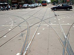
A grand union is a rail track junction where two double-track railway or tramway lines cross at grade, often in a street intersection or crossroads. A total of sixteen railroad switches (sets of points) allow streetcars (or in rarer installations, trains) coming from any direction to take any of the three other directions. The same effect may be achieved with two adjacent wyes if the location allows for space.

Contents

Complexity

These types of complex junction are expensive to build and expensive to maintain. Special parts, sometimes made of manganese steel, are needed for each location where one rail crossed another (a "frog"); these parts often need to be custom-made and fitted for each single location, depending on the specific angle of crossing of the intersecting streets.

A full grand union junction consists of 88 frogs (where one rail crosses another rail), and 32 switchpoints (point blades) if single-point switches are not used. A tram or train crossing the junction will encounter four or twenty frogs within the space of crossing the junction.

For all of the possible tracks of a grand union to be used during normal operation, at least six different tram routes have to cross the union. In an intersection with lines oriented towards cardinal directions, these could be: north-south, north-east, north-west, south-east, south-west, and east–west.

Three-quarter, half and butterfly unions

Three-quarter unions are similar to grand unions in that they are also rail track junctions where two double-track railway lines cross at grade, often in a street intersection or crossroads; the primary difference being that one corner of the crossing does not have curved junction tracks, with the union having a total of 12 railroad switches (sets of points).

Half unions are similar, but have curved junction tracks on only two adjoining corners of the intersection, with a total of eight switches.

Butterfly unions share the total of eight switches, but the curved junction tracks are on opposing corners.

Examples

Europe

Austria

  • Vienna has a three-quarter union at Quellenplatz, 48°10′32.3″N 16°22′24.7″E

Belgium

  • Brussels has a grand union at carrefour Buyl – Général Jacques, 50°49′05.9″N 4°22′45.8″E

Croatia

  • Zagreb has a grand union at the intersection of Savska and Vodnikova Street, 45.80545°N 15.96627°E, and a three-quarter union at the intersection of Vukovarska and Držićeva Avenue, 45.80113°N 15.999°E.

Czech Republic

  • Brno, has a three-quarter union located at 49°12′16.24″N 16°37′25.54″E. [1]
  • Olomouc, has one grand union located at 49°35′44.42″N 17°14′50.27″E. [2]
  • Prague, has three grand unions, first at 50°6′12.65″N, 14°28′23.89″E [3] the second at 50°5′55.94″N, 14°25′59.76″E. [4] and the third at 50°4′23.19″N 14°24′50.30″E, this Grand Union was rebuilt in 2003 and has curved trackwork as the streets are not aligned at the river crossing.

Estonia

  • Tallinn will have the first butterfly union at the intersection of Narva maantee, Hobujaama and A. Laikmaa streets at 59°26′14.07″ N 24°45′26.21″ E. The crossing line is under construction as of 2023 and is expected to start service in 2024.

Finland

  • Helsinki has a three-quarter union at the intersection of Simonkatu and Mannerheimintie, 60.1699°N 24.9385°E, and a butterfly union at the intersection of Runeberginkatu and Mannerheimintie, 60.1817°N 24.9273°E. These are probably the northernmost unions in the world.

Germany

Berliner Platz, in Kiel (1971). Auto- und Strassenbahnverkehr am Berliner Platz (Kiel 47.959).jpg
Berliner Platz, in Kiel (1971).
  • Cologne has one grand union at the stop Aachener Straße / Gürtel at 50°56′13.2″N 6°54′30.4″E, and one three-quarter union at Barbarossaplatz 50°55′42.9″N 6°56′33.7″E
  • Cottbus has one grand union at 51°45′39.86″N 14°19′51.39″E and a three-quarter union at 51°44′57.54″N 14°19′42.50″E. [5]
  • Dresden has a grand union at 51°3′49.47″N 13°44′48.95″E (Albertplatz); a five-eighths grand union at 51°3′47.55″N 13°44′13.53″E there is only a single connection on the north route, and a butterfly union at 51°2′58.09″N 13°44′39.27″E (Dresden HBf)
  • Duisburg has a butterfly union at 51°30′7.44″N 6°45′25.78″E
  • Kiel had a half union on Berliner Platz.
  • Erfurt has a butterfly union at 50.976099°N 11.034358°E, its modern city center: the Anger.
  • Karlsruhe's system has three grand unions located at Stop Mathystrasse (49°0′8.96″N 8°23′39.77″E), [6] located at Entenfang (49°00′37.1″N 8°21′31.8″E)., [7] and the third one established in 2018 at intersection Rüppurrer Str. and Baumeisterstr. [8] [9] A fourth one is planned at the next intersection of Kriegsstr. and Baumeisterstr. [10]
  • Kassel's system has a single grand union located at 51°19′4.87″N 9°30′1.02″E and a three-quarter union at 51°18′43.02″N 9°29′29.64″E. [11] [12]
  • Leipzig has a grand union at 51°20′39.35″N 12°22′15.99″E it is unique in interfacing with four tracks at Goerdelerring tram stop. There is a three-quarter union at 51°19′56.49″N 12°20′19.68″E, a half union at 51°20′31.31″N 12°21′31.15″E and butterfly unions at 51°19′12.95″N 12°19′48.80″E, 51°20′20.36″N 12°21′44.96″E and 51°21′44.93″N 12°21′55.79″.
  • Munich has one real grand union at Ostfriedhof since the last track alteration in 2015 at 48°07′8.6″N 11°35′1″E. While not a traditional grand union, the Munich tram system has also a "Grand circle" which has the same route function as a grand union and also provides a loop for all lines, it is located at Maxmonument in Maximilianstrasse, 48°8′15.27″N, 11°35′17.02″E. [13]

Italy

  • Milan: the Milan tram network currently has two grand unions. The first is a non standard design with divided North South tracks around a monument located at piazza 24 Maggio, [14] and the second located nearby at piazzale Porta Lodovica. [15] [note 1] There used to be another large one until the 1990s located at piazza della Repubblica, [16] but it has since reduced to a wye junction still keeping the layout of diverging routes by the removal of the straight route to via Vittor Pisani.

Netherlands

  • Amsterdam, Netherlands: As of 2009, the Amsterdam tram system continues to have four grand unions. However, none of them has tram routes running in all directions under normal operation. They are located at 52°21′17.39″N 4°54′4.49″E; [17] 52°21′45.91″N 4°52′31.04″E [18] and 52°22′12.13″N 4°51′0.94″E. [19] and 52°21′9.99″N 4°53′28.04″E; [20]
  • Rotterdam: the Rotterdam tram system has one three-quarter union, located at Vasteland – Westzeedijk 51°91′14.94″N, 4°47′74.85″E; [21]
  • The Hague: The Hague tram system has one butterfly union at the crossing of the Laan van Meerdervoort and the Koningin Emmakade/Waldeck Pyrmontkade (S100), (52°04′54.1″N 4°17′15.9″E). There is also a half union at the crossing of the Loosduinseweg and the Monstersestraat, (52°04′22.2″N 4°17′30.5″E)

Poland

  • Kraków has three grand unions, one at 50°3′27.42″N 19°57′32.40″E one at 50°3′23.40″N 19°56′43.63″E and one at 50°4′46.65″N 20°1′38.49″E. There is a "Grand Circle" at Centralny Square, 50°4′19.56″N 20°2′14.46″E, the "Grand Circle" which has the same route function as a grand union and also provides a loop for all lines. There is a three-quarter union at 50°3′6.26″N 19°56′30.22″E and a five-eighths union at 50°4′24.31″N 20°1′2.89″E.
  • Poznań: The Poznań Tram system has 6 grand unions, which may be the most extant in any city. They are located at: 52°24′37.94″N, 16°54′48.53″E; [22] 52°24′28.02″N, 16°54′44.97″E; [23] 52°24′9.54″N, 16°53′20.65″E; [24] 52°23′24.39″N, 16°53′39.07″E; [25] 52°22′48.68″N, 16°56′35.21″E [26] and 52°23′57.53″N, 16°57′8.97″E. [27] All can be seen in detail on Google Earth.
  • Warsaw: The Warsaw system has four grand unions, first at 52°14′30.79″N 20°59′37.00″E [28] second at 52°14′13.30″N 20°58′48.62″E, [29] third at 52°22'01.84"N, 21°00'49.14"E, and fourth at 52°18'87.92"N 21°00'20.16"E.

There is a three-quarter union at 52°15′17.24″N 20°58′57.11″E, [30] and 52°26'35.68"N 21°02'07.88"E.

Russia

  • Kazan: Kazan Tram system had one grand union. It is located at 55.780459 N, 49.112853 E. Street View in Google Earth shows that this Grand Union has been partially removed, portions still remain in the pavement in 2013. [31]
  • Moscow: Moscow Tram system has one three-quarter union on Preobrazhenskaya Ploshad [32]
  • Saint Petersburg: Saint Petersburg Tram system has a three-quarter union on Svetlanovskaya Ploshad, [33] a three-quarter union on Irinovskiy Prospekt [34] and a butterfly union on Prospekt Kultury [35]
  • Angarsk: Angarsk Tram system had one Full grand union which was partially dismounted in 2000-s [36]
  • Kaliningrad: Kaliningrad Tram system had one grand union. It is located at 54.712167N, 20.523258E This Grand Union has been partially removed in 2009.[1]

Slovakia

  • Košice, had one grand union at 48°42′18″N 21°14′35″E, in 2018 that was replaced with a Grand Circle, which can be seen on Google Earth.

Switzerland

  • Basel, the Basel system has a grand union at 47 33' 48.62"N 7 35' 57.96"E and a (nonstandard) grand union located at 47°33′4.83″N 7°35′41.89″E. [37]

United Kingdom

Americas

Canada

“7/8ths” union
BSicon vCONTfga.svg
BSicon numN000.svg
BSicon kvSTR-c2.svg
BSicon kvSTR2.svg
BSicon kvSTR3.svg
BSicon uvSTR.svg
BSicon kvSTR-c3.svg
BSicon vCONTfgaq.svg
BSicon kvSTR2+r.svg
BSicon kvSTRr+1.svg
BSicon uvSTRq.svg
BSicon kvSTRc1.svg
BSicon kvSTRc2.svg
BSicon kvSTRc3.svg
BSicon kvSTRc4.svg
BSicon uvKRZv.svg
BSicon kvSTR3+l~r.svg
BSicon kvSTRl+4.svg
BSicon uvSTRq.svg
BSicon vCONTfgeq.svg
BSicon kvSTR-c1.svg
BSicon kvSTR+1~r.svg
BSicon kvSTR+4.svg
BSicon uvSTR.svg
BSicon vCONTfge.svg
Toronto: King×Dufferin
  • Toronto: The most extensive street railway system in the Americas is the Toronto streetcar system of the Toronto Transit Commission in southern Ontario, which has many four-way streetcar intersections, including the only extant grand unions remaining in the Western Hemisphere. The system includes three grand unions, one seven-eighths union (one curve short of a grand union), four three-quarter unions (missing 2 curves at a single corner), three more unions with 6 curves and many unions in various configurations with less than 6 curves. The "traditional" grand unions are located at Bathurst and King (43°38′38.14″N 79°24′9.50″W); Spadina and King (43°38′43.73″N 79°23′42.09″W) and Spadina and Queen (43°38′55.43″N 79°23′46.91″W). [41] King and Dufferin (43°38′20.15″N 79°25′38.45″W) is a "seven-eighths union": it is missing the curve from southbound to westbound. [42]
  • Brantford, Ontario The Brantford Municipal Railway installed a UK-made grand union at Colborne and Market Streets circa 1910. It remained in service until the end of streetcar service in the city on 31 January 1940. [43] It was taken up for scrap in 1940. [44]

United States

  • Akron: The Akron streetcar system had one grand union at the intersection of Main and Exchange Streets, [45]
  • Boston: The Boston Elevated Railway had four grand unions on Washington Street, at Hanover Street, [46] Boylston and Essex Streets, [47] Southampton Street, and Dover Street. [48] Dover Street was also a part of another, albeit asymmetrical, grand union where it intersected Tremont Street and terminated into Berkeley Street, leading to another grand union at the intersection of Berkeley and Columbus Avenue. Another grand union existed at the intersection of Massachusetts Avenue and Huntington Avenue. [49] An eighth grand union had existed at Dewey Square. [50]
  • Chicago: The Chicago Transit Authority has a three-quarter union at Tower 18, located on the northwest corner of The Loop. This union has the notable distinctions of not only being built entirely on elevated bridgework over the streets below, but also being fully equipped with third rails for power distribution. [51]
  • Philadelphia: SEPTA has a surviving example of a half union located at the intersection of Chester Avenue and 49th Street; [52] [53] and PTC previously had two butterfly unions, the first at Erie Ave and Old York Road [54] and the second at Lancaster Avenue and 33rd Street; [55] as well as a second half union at Allegheny and 22nd Street. [56]
  • Pittsburgh: Pittsburgh's trolley system had a three-quarter union located at the intersection of 5th Avenue and Craig St. [57]
  • Rochester, New York: Rochester's surface streetcar system had three full grand unions, all of which were located on Main Street, as well as two three-quarter unions, and three half unions. [58] [59]
  • Seattle: The Seattle-Tacoma Interurban was believed to have a single grand union, located at N. 34th St. and Fremont Ave. [60]
  • San Francisco: The San Francisco Municipal Railway's light rail line has a quarter union at 4th Street and King Street. The N Judah route crosses 4th, and the current T Third route uses the turn connecting the tracks on King northwest of the intersection to those on 4th to the southwest; the tracks on 4th across King lead to the Central Subway, which is planned to carry the T Third when it opens.
  • Salt Lake City: The Utah Transit Authority's TRAX system has 2 half unions(Main Street Interlocking at 40°45′38.2″N 111°53′28.3″W and the Airport Junction Interlocking at 40°46′09.7″N 111°54′08.4″W), 1 quarter union (Union Interlocking at 40°43′21.1″N 111°53′48.8″W), and a three interlocking combination that offers the effect of a half union (Lovendahl/Ephraim/Sugar Interlockings at 40°37′56.2″N 111°53′54.7″W).

Galleries

Oceania

See also

Notes

  1. In summer 2022 it is going to lose one of the diverging tracks. Works ongoing.

Related Research Articles

<span class="mw-page-title-main">Roundabout</span> Traffic intersection

A roundabout, a rotary and a traffic circle are types of circular intersection or junction in which road traffic is permitted to flow in one direction around a central island, and priority is typically given to traffic already in the junction.

<span class="mw-page-title-main">Stockton, Maryland</span> CDP in Maryland, United States

Stockton [stɑːktɪn] is a census-designated place (CDP) in Worcester County, Maryland, United States. The population was 92 at the 2010 census. It is part of the Salisbury, Maryland-Delaware Metropolitan Statistical Area.

<span class="mw-page-title-main">Huma County</span> County in Heilongjiang, Peoples Republic of China

Huma County is a county in the far north of the Heilongjiang province, People's Republic of China. The county seat is located on the right (southwestern) bank of the Amur River, a few kilometers upstream from the fall of the Huma River into the Amur. It is under the administration of the Daxing'anling Prefecture.

<span class="mw-page-title-main">Itabirito</span> Municipality in Southeast, Brazil

Itabirito is a municipality in the Minas Gerais state of Brazil. Its population is estimated to have 52,446 people in 2020. The city belongs to the mesoregion Metropolitan of Belo Horizonte and to the microregion of Ouro Preto.

<span class="mw-page-title-main">Shanghai, West Virginia</span> Unincorporated community in West Virginia, United States

Shanghai is an unincorporated community in Berkeley County, West Virginia, United States. The town is nestled in Back Creek Valley between Leading Ridge and North Mountain. Shanghai lies at the junction of West Virginia Secondary Route 7 and Secondary Route 18.

Lions Drag Strip was an American raceway in the Wilmington district of Los Angeles, California, adjacent to Long Beach that existed from 1955 to 1972. The track was named after its sponsors Lions Clubs International and featured many races that were sanctioned by the American Hot Rod Association (AHRA).

<span class="mw-page-title-main">New York State Route 52</span> East-west route from Narrowsburg to Carmel

New York State Route 52 (NY 52) is a 108.72-mile-long (174.97 km) state highway in the southeastern part of the state. It generally runs from west to east through five counties, beginning at the Pennsylvania state line in the Delaware River near Narrowsburg, crossing the Hudson River on the Newburgh–Beacon Bridge, and ending in Carmel. NY 52 and NY 55, both major east–west routes of the Mid-Hudson Region, run parallel to each other, intersecting in downtown Liberty.

<span class="mw-page-title-main">Thierbach Power Station</span>

Thierbach Power Station was a brown coal-fired power station in the Leipzig Bay at Espenhain-Thierbach, Germany. It had a 300-metre-tall chimney, which belonged to the tallest free-standing structures of the former GDR.

<span class="mw-page-title-main">RAF Great Dunmow</span> Former Royal Air Force station in Essex, England

Royal Air Force Great Dunmow or more simply RAF Great Dunmow is a former Royal Air Force station in the parish of Little Easton, Essex, England. The airfield is located approximately 1.4 miles (2.3 km) mi west of Great Dunmow, north of the A120.

<span class="mw-page-title-main">A2 motorway (Cyprus)</span>

The A2 motorway in Cyprus is a road which branches off the A1 at Pera Chorio-Nisou and connects to the A3. It is referred to locally as the Nicosia - Larnaca motorway. It is also called "the tube" because it is mostly straight with a very limited number of exits. Two of its 6 junctions are limited access to facilitate access to Athienou.

Longue Pointe is a place located in northern Quebec, Canada. It is part of the Cree Nation of Chisasibi Category I Land but has no permanent population. It is used by both Cree and Inuit natives as a harbour for their fishing boats.

E.A. Vaughn Wildlife Management Area is a state wildlife management area (WMA) of Maryland that consists of two separate parcels of land on Chincoteague Bay in Worcester County, between the villages of Girdletree and Stockton.

<span class="mw-page-title-main">Florida State Road 83</span> State highway in Florida, United States

State Road 83 is the state designation for U.S. Route 331 between US 98(SR 30) in Santa Rosa Beach and US 90(SR 10) in DeFuniak Springs. It also includes an independent route from DeFuniak Springs to the Florida-Alabama State Line. The entire route is in Walton County.

<span class="mw-page-title-main">Edgemont Memorial Park</span> Municipal park in Montclair, New Jersey

Edgemont Park is a park in Montclair, New Jersey, in the United States of America. It shares a name with the nearby Edgemont Elementary School.

Nowy Głuchówek is a village in the administrative district of Gmina Rawa Mazowiecka, within Rawa County, Łódź Voivodeship, in central Poland.

Bengbu Airport is a dual-use airport in Bengbu, Anhui Province, China.

<span class="mw-page-title-main">Winston-Salem Air Force Station</span> Closed United States Air Force General Surveillance Radar station in North Carolina

Winston-Salem Air Force Station is a closed United States Air Force General Surveillance Radar station that was active from 1956 to 1970. It is located 1 mile (1.6 km) southeast of Winston-Salem, North Carolina.

Samayasangili is a village in Namakkal district in the Indian state of Tamil Nadu. It consists of five sub villages includes Samayasangilli, Thottipalayam Pudur, Thottipalayam Palaiyur, Sengutaipalayam, Seerampalayam.

SM <i>UB-122</i> German Imperial Navy U-boat

SM UB-122 was a German Type UB III submarine or U-boat in the German Imperial Navy during World War I. She was commissioned into the German Imperial Navy on 4 March 1918 as SM UB-122.

Lake Dot or is a 5.42-acre (21,900 m2) natural freshwater lake located in central Orlando, Florida. Lake Dot, a nearly round lake, is in the Lake Dot neighborhood of the city. It is in a completely urbanized area with homes and businesses surrounding it. A fountain is near the center of this lake. The north side of the lake is bounded by Colonial Drive, a very busy thoroughfare. It appears a small portion of the lake was filled in to allow Colonial to run in a straight line. On the south is Concord Street and on the east and west sides, Lake Dot is bordered by Lake Dot Circle.

References

  1. "49°12'16.2"N 16°37'25.5"E" (Map). Google Maps .
  2. "49°35'44.4"N 17°14'50.3"E" (Map). Google Maps .
  3. "50°06'12.7"N 14°28'23.9"E" (Map). Google Maps .
  4. "50°05'55.9"N 14°25'59.8"E" (Map). Google Maps .
  5. "Gleisplan der Straßenbahn Cottbus" (in German).
  6. "49°00'09.0"N 8°23'39.8"E" (Map). Google Maps .
  7. "49°00'37.1"N 8°21'31.8"E" (Map). Google Maps .
  8. "Die Kombilösung Karlsruhe: Für Gründung von Masten wird Rüppurrer Straße zeitweise schmaler" (in German). 16 October 2017.
  9. "49°00'16.3"N 8°24'37.9"E" (Map). Google Maps .
  10. "Planning approval Map" (PDF) (in German).
  11. "51°19'04.9"N 9°30'01.0"E" (Map). Google Maps .
  12. "51°18′43.0"N 9°29′29.6"E" (Map). Google Maps . Retrieved 2018-07-05.
  13. "48°08'15.3"N 11°35'17.0"E" (Map). Google Maps .
  14. "Piazza Ventiquattro Maggio" (Map). Google Maps .
  15. "Piazzale di Porta Lodovica" (Map). Google Maps .
  16. "45°28'42.2"N 9°11'49.0"E" (Map). Google Maps .
  17. https://maps.google.com/maps?f=q&source=s_q&hl=en&geocode=&q=52%C2%B021%2717.39%22N+4%C2%B054%274.49%22E&aq=&sll=37.926868,-95.712891&sspn=33.816707,79.013672&ie=UTF8&ll=52.354844,4.901218&spn=0.000423,0.001717&t=k&z=20 Google Maps: Van Woustraat 83III 1074 Amsterdam, the Netherlands
  18. https://maps.google.com/maps?f=q&source=s_q&hl=en&geocode=&q=52%C2%B021%2745.91%22N++4%C2%B052%2731.04%22E&aq=&sll=52.352854,4.89117&sspn=0.000423,0.001206&ie=UTF8&ll=52.362792,4.875219&spn=0.000423,0.001206&t=k&z=20 Google Maps: Eerste Constantijn Huygensstraat 98 1054 Amsterdam, the Netherlands
  19. https://maps.google.com/maps?f=q&source=s_q&hl=en&geocode=&q=52%C2%B022%2712.13%22N++4%C2%B051%270.94%22E&aq=&sll=52.362857,4.875219&sspn=0.000423,0.001206&ie=UTF8&ll=52.37002,4.850273&spn=0.000423,0.001206&t=k&z=20&layer=c&cbll=52.370064,4.850241&panoid=MEYZKi8jBNVh2LMqNmB2-w&cbp=12,246.16718307695862,,0,5 Google Maps: Jan Evertsenstraat 144II 1056 Amsterdam, the Netherlands
  20. https://maps.google.com/maps?f=q&source=s_q&hl=en&geocode=&q=52%C2%B021%279.99%22N++4%C2%B053%2728.04%22E&aq=&sll=52.355027,4.901474&sspn=0.000598,0.001206&g=52%C2%B021%2717.39%22N+4%C2%B054%274.49%22E&ie=UTF8&ll=52.352804,4.89117&spn=0.000423,0.001206&t=k&z=20 Google Maps: Ceintuurbaan 55–157 1072 Amsterdam, the Netherlands
  21. https://maps.google.com/maps?q=51.911494,+4.477485&hl=en&sll=51.911483,4.477728&sspn=0.002862,0.008256&t=h&z=16 Google Maps: Vasteland – Westzeedijk Rotterdam, The Netherlands
  22. https://maps.google.com/maps?q=52%C2%B024%2737.94%22N,+16%C2%B054%2748.53%22E&hl=en&ie=UTF8&ll=52.410529,16.913557&spn=0.000439,0.001206&sll=52.407766,16.912468&sspn=0.000439,0.001206&t=k&z=20 Google Maps: Franklina Roosevelta 11, Poznań, Poland
  23. https://maps.google.com/maps?q=52%C2%B024%2728.02%22N,+16%C2%B054%2744.97%22E&hl=en&ie=UTF8&ll=52.407766,16.912468&spn=0.000439,0.001206&sll=52.402659,16.889031&sspn=0.000439,0.001206&t=k&z=20 Google Maps: Rondo Kaponiera, Poznań, Poland
  24. "52°24'09.5"N 16°53'20.7"E" (Map). Google Maps .
  25. "52°23'24.4"N 16°53'39.1"E" (Map). Google Maps .
  26. "52°22'48.7"N 16°56'35.2"E" (Map). Google Maps .
  27. "52°23'57.5"N 16°57'09.0"E" (Map). Google Maps .
  28. https://maps.google.com/maps?q=52%C2%B014%2730.79%22N++20%C2%B059%2737.00%22E&hl=en&ie=UTF8&ll=52.241881,20.993619&spn=0.000441,0.001206&sll=52.236994,20.980161&sspn=0.000441,0.001206&t=k&z=20 Google Maps: 629 Warszawa, Poland
  29. https://maps.google.com/maps?q=52%C2%B014%2713.30%22N++20%C2%B058%2748.62%22E&hl=en&ie=UTF8&ll=52.236994,20.980161&spn=0.000441,0.001206&sll=52.254707,20.982457&sspn=0.000882,0.002411&t=k&z=20 Google Maps: Rondo Kercelak, Warszawa, Poland
  30. https://maps.google.com/maps?q=52%C2%B015%2717.24%22N+20%C2%B058%2757.11%22E&hl=en&ie=UTF8&ll=52.254707,20.982457&spn=0.000882,0.002411&sll=48.137884,11.588259&sspn=0.000961,0.002411&t=k&z=19 Google Maps: Rondo Zgrupowania AK "Radosław", Warszawa, Poland
  31. https://maps.google.com/maps?q=55.780459,49.112853&hl=en&ll=55.780444,49.113012&spn=0.00081,0.002411&sll=55.780459,49.112862&sspn=0.00162,0.004823&t=k&z=19 Google Maps: 55.780459 N, 49.112853 E
  32. https://maps.google.com/maps?f=q&source=s_q&hl=en&geocode=&q=moscow&sll=-34.928621,138.599959&sspn=1.020084,1.683655&ie=UTF8&hq=&hnear=Moscow,+Russia&ll=55.795831,37.714243&spn=0.000683,0.001644&t=k&z=19 Google Maps: Preobrazhenskaya Ploshad, Moscow Russia
  33. "Google Maps".
  34. "Google maps".
  35. "Google maps".
  36. "Google Maps".
  37. https://maps.google.com/maps?f=q&source=s_q&hl=en&geocode=&q=47%C2%B033%274.83%22N++7%C2%B035%2741.89%22E&aq=&sll=51.317927,9.500285&sspn=0.000433,0.001206&ie=UTF8&ll=47.551401,7.595375&spn=0.000934,0.003433&t=k&z=19 Google Maps: Aeschenplatz 1 4052 Basel, Switzerland
  38. Edmonton Radial Railway 1924 track map Archived July 6, 2011, at the Wayback Machine
  39. "Edmonton Radial Railway Society photograph, 109th St. and Jasper Ave., 1904". Edmonton-radial-railway.ab.ca. Retrieved 2013-01-07.
  40. "Musée McCord Museum photograph – Tramway crossing under construction, 1893". Mccord-museum.qc.ca. Retrieved 2013-01-07.
  41. TORONTO TRANSIT COMMISSION – 2006 STREETCAR TRACK LAYOUT AND ROUTE MAP (PDF) (Map).
  42. "Toronto streetcar system March 2011". Transit Toronto.
  43. "Traction on the Grand", John Mills, Railfare Publishing, 1977.
  44. Page 74, Canadian Rail Passenger Review Number 3, 2000, author Douglas NW Smith
  45. "Downtown digging uncovers remnants of Akron's streetcar era". Akron Beacon Journal. 2019-04-07. Retrieved 2019-04-08.
  46. "Boston 1899–1915 Plate 033". WardMaps LLC. Retrieved 2016-12-25.
  47. "Boston 1899–1915 Plate 029". WardMaps LLC. Retrieved 2016-12-25.
  48. "Boston 1899–1915 Plate 026". WardMaps LLC. Retrieved 2016-12-25.
  49. "Boston 1899–1915 Plate 025". WardMaps LLC. Retrieved 2016-12-25.
  50. "Boston 1899–1915 Plate 032". WardMaps LLC. Retrieved 2016-12-25.
  51. www.Chicago-L.org Photo "tower18l.jpg" taken June 19, 2006.(Retrieved November 2009)
  52. "Original PRT specialwork drawing sheet 10, chart 48". Phillytrolley.org. 1919-06-30. Retrieved 2013-01-07.
  53. "PTC Track Map detail, 1954, bottom right corner of image". Phillytrolley.org. Retrieved 2013-01-07.
  54. "Original PRT specialwork drawing sheet 16, chart 66". Phillytrolley.org. 1919-06-30. Retrieved 2013-01-07.
  55. "PTC Track Map detail, 1954, center left of image". Phillytrolley.org. Retrieved 2013-01-07.
  56. "PTC Track Map detail, 1954, center left of image". Phillytrolley.org. Retrieved 2013-01-07.
  57. "Partial photo of location". BCoolidge Pittsburgh Trolleys. 2005-11-24. Retrieved 2016-10-25.
  58. "Map of Rochester Subway, see inset section for surface track layout". Rocwiki.org. 2005-03-20. Retrieved 2013-01-07.
  59. "Powers Building photograph, Rochester NY, 1904". Shorpy.com. Retrieved 2013-01-07.
  60. "Waiting-for-8-14-23-THENWEB.JPG (1200x819 pixels)". pauldorpat.com. Archived from the original on 31 January 2013. Retrieved 2 February 2022.
  61. Graham Stewart, The End of the Penny Section: When Trams Ruled the Streets of New Zealand, rev ed. (Wellington: Grantham House, 1993), p. 149.
  62. "Victorian Heritage Database: photographs and diagram of junction". Vhd.heritage.vic.gov.au. Retrieved 2013-01-07.
  63. "37°52'21.6"S 145°01'29.0"E" (Map). Google Maps .