Maladeta

Last updated • 4 min readFrom Wikipedia, The Free Encyclopedia
Maladeta
Maladeta.jpg
Maladeta
Highest point
Elevation 3,312 m (10,866 ft)
Listing List of mountains in Aragon
Coordinates 42°38′50″N0°38′22″E / 42.64722°N 0.63944°E / 42.64722; 0.63944
Naming
English translationfrom "damned mountains"
Language of name Spanish
Geography
Pyrenees topographic map-en.svg
Red triangle with thick white border.svg
Maladeta
Location in the Pyrenees
Location Ribagorza, Aragon, Spain
Parent range Pyrenees
Climbing
First ascent 28 September 1817

Maladeta (3,312 m) is a mountain in the Pyrenees, close to the highest peak in the range, Aneto. It is located in the Natural Park of Posets-Maladeta in the town of Benasque in Province of Huesca, Aragon, Spain. Its northern slope contains the 37-hectare (91-acre) Maladeta Glacier, which is divided into the six-hectare (15-acre) Western Maladeta and the 31-hectare (77-acre) Eastern Maladeta.

Contents

Maladeta was previously considered to be highest peak in the area, and attempts to reach its summit took priority over the other peaks in the range. The first successful ascent of the peak was made by Johann Jacob Friedrich Wilhelm Parrot with guide Pierre Barrau in 1817. [1]

Etymology

The name "Maladeta" comes from the Spanish montes malditos, which means "Damned Mountains". According to some authorities the local name for the massif was Mala hita ("bad rocks" or "bad upper regions"). When French travellers came to the region they translated the name into the French as "Maladette", on the basis that it was cognate with the Italian term Maladetta (feminine form of "damned"). Subsequently, the mountain became known as Maladeta, a term that encompasses the entire massif. [1]

History

The peak of Coronas, with Medio and Maldito, with Maladeta to the far right, taken from the summit of Aneto Pic du Milieu et pic de la Maladetta, vue prise du sommet du Nethou, aout.jpg
The peak of Coronas, with Medio and Maldito, with Maladeta to the far right, taken from the summit of Aneto

While not the highest peak in the local group of mountains, Maladeta was named for the entire group, which is also called Montes Malditos. It attracted the most interest from climbers, especially in the early nineteenth century, as its summit appears in the foreground from the natural entrance to the valley via the port of Benasque or when arriving from France. From this vantage point, the Cresta Portillones hides the true height of its eastern neighbour Aneto, which is taller and has more extensive glaciers. The first attempts to reach the peak were by Ramond in 1787, Ferrieres in 1801, and Louis Cordier in 1802. It wasn't until German naturalist Johann Jacob Friedrich Wilhelm Parrot, with guide Pierre Barrau, climbed to the summit of the mountain on 28 September 1817 [1] that Aneto was discovered to be higher.

Pierre Barrau, considered to be the leading expert in the area, was killed in a crevice of the Maladeta glacier in 1824. As a result, locals became fearful of venturing out on the ice, considering it cursed. The movement of the glacier in 1931 exposed the body.

In the early twentieth century, the Refugio de la Renclusa mountain hut was opened. It has a capacity of 93 and is the most common starting point for climbing the Aneto. It is located 2,140 m (7,021 ft) above sea level and is accessed via a path that leaves from the La Besurta recreational area. [2] [3] Due to the variety of wildlife in the valleys and the sensitivity of its glaciers (the most southerly in Europe), Maladeta was declared a natural park in 1994, together with the entire range, and part of the Pyrenean Glaciers Natural Monument.

Geography

Map of the Maladeta range, and the valleys and mountains surrounding it Valle de Benasque.jpg
Map of the Maladeta range, and the valleys and mountains surrounding it

Maladeta rises to 3,308 metres (10,853 ft) above sea level in the heart of the Pyrenees along the border between France and Spain. [4] The summit is located northeast of the Province of Huesca and occupies the centre of the Montes Malditos. It is connected to Aneto to the east by a 3,000-metre (9,800 ft) row of peaks called the Cresta del Medio (Pico Maldito, Pico del Medio, Pico de Coronas), which, along with the crest of the Portillones, give the appearance of being solid. [5]

The snow from its slopes feeds the headwaters of the Ésera and Ballibierna rivers, both on the south side.

The Maladeta range is surrounded by valleys. A hill of over 8,200 feet (2,500 m), crowned by the Perdiguero, separates the valley of Arán from France. The wider and more compact Spanish side, which is less accessible, is separated from the foothills by the gorges and ravines of the Posets and Maladeta mountain ranges. The Cerler alpine ski resort lies two valleys further south. [6]

Climbing routes

La Renclusa mountain hut Refugio de la Renclusa01.JPG
La Renclusa mountain hut

The normal route of ascent is common to both Maladeta and Aneta up to the height of the upper Portillón. There one continues in a straight line to the bottom of the crest of the Maladeta, which is accessible via a steep passage to a very distinctive and visible rock. The route into the corridor can be very hazardous because a deep bergschrund that usually opens in the glacier following the winter. [7] Ascents of the mountain are only recommended for experienced climbers.

The mountain hut La Renclusa, located in the foothills at 2,500-metre (8,200 ft), is the usual starting point for ascents of Maladeta and Aneto.

See also

Related Research Articles

<span class="mw-page-title-main">Pyrenees</span> Range of mountains in southwest Europe

The Pyrenees are a mountain range straddling the border of France and Spain. They extend nearly 500 km (310 mi) from their union with the Cantabrian Mountains to Cap de Creus on the Mediterranean coast, reaching a maximum altitude of 3,404 metres (11,168 ft) at the peak of Aneto.

<span class="mw-page-title-main">Province of Huesca</span> Province of Spain

Huesca, officially Huesca/Uesca, is a province of northeastern Spain, in northern Aragon. The capital is Huesca.

<span class="mw-page-title-main">Aneto</span> The highest mountain in the Pyrenees

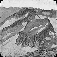
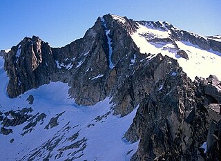
Aneto is the highest mountain in the Pyrenees and in Aragon, Spain's third-highest mountain, reaching a height of 3,404 metres. It is in the Spanish province of Huesca, the northernmost of three Aragonese provinces, 6 kilometres south of the France–Spain border. It forms the southernmost part of the Maladeta massif.

<span class="mw-page-title-main">Dufourspitze</span> Highest mountain in Switzerland

The Dufourspitze is the highest peak of Monte Rosa, an ice-covered mountain massif in the Alps. Dufourspitze is the highest mountain of both Switzerland and the Pennine Alps and is also the second-highest mountain of the Alps and Western Europe, after Mont Blanc. It is located between Switzerland and Italy. The peak itself is located wholly in Switzerland.

<span class="mw-page-title-main">Monte Rosa</span> Massif in Switzerland and Italy

Monte Rosa is a mountain massif in the eastern part of the Pennine Alps, on the border between Italy and Switzerland (Valais). The highest peak of the massif, amongst several peaks of over 4,000 m (13,000 ft), is the Dufourspitze, the second highest mountain in the Alps and western Europe, after Mont Blanc. The east face of the Monte Rosa towards Italy has a height of about 2,400 metres (7,900 ft) and is the highest mountain wall of the Alps.

<span class="mw-page-title-main">Vignemale</span>

The Vignemale, at 3,298 metres, is the highest of the French Pyrenean summits. It lies on the border between the Department of Hautes-Pyrénées, in Occitanie and Gascony, France and Sobrarbe, in Huesca, Aragon, Spain, and the peak is split between the two countries.

<span class="mw-page-title-main">Cerler</span>

Cerler, officially called Aramón Cerler, is a ski resort situated above the village of Cerler in the high Benasque Valley, near the town of Benasque in the central Pyrenees. Near Cerler are the highest peaks of the Pyrenees, Aneto, Monte Perdido, and Posets.

<span class="mw-page-title-main">Balaïtous</span>

The Balaitús (Spanish) or Pic du Balaïtous (French) is a granitic massif of the Pyrenees, located right on the border between Spain and France.

<span class="mw-page-title-main">Henry Russell (explorer)</span>

Henry Patrick Marie, Count Russell-Killough (1834–1909) was one of the pioneers of Pyrenean exploration, known for his obsession with the Vignemale.

<span class="mw-page-title-main">Pico Posets</span>

Pico Posets or Punta de Llardana is the second highest peak of the Pyrenees, after Aneto. It is located in the Spanish province of Huesca and is 3,369 metres (11,053 ft) high.

<span class="mw-page-title-main">Aspe peak</span> Mountain in Spain

Aspe peak is a mountain in the western Pyrenees of Huesca; which is situated on the west side of the Aragon Valley near the towns of Villanúa and Canfranc. The peak is 2,645 metres (8,678 ft) AMSL high. It is adjoined to the peak of Zapatilla.

<span class="mw-page-title-main">Posets–Maladeta Natural Park</span>

The Natural Park of Posets–Maladeta is a Natural park located in northern Province of Huesca, Aragón, northeastern Spain. It is set within the Pyrenees.

Three-thousanders are mountains with a height of between 3,000 metres (9,800 ft), but less than 4,000 metres (13,000 ft) above sea level. Similar terms are commonly used for mountains of other height brackets e. g. four-thousanders or eight-thousanders. In Britain, the term refers to mountains above 3,000 feet (910 m).

<span class="mw-page-title-main">Pic Schrader</span>

The Pic Schrader or Grand Batchimale is a central Pyrenean summit, culminating at 3,177 m (10,423 ft), located for the most part in Spain. It buckles the Louron valley with its impressive silhouette

<span class="mw-page-title-main">Renclusa Refuge</span>

The Renclusa refuge is a refuge located in the Spanish Pyrenees at the base of the massif de la Maladeta, at 2,140 m (7,020 ft) high, in the Ésera valley. It is the starting point for excursions to the summit of la Maladeta, of the monts Maudits and Aneto. It lies in the commune of Benasque, north-east of Huesca province, Aragon (Spain).

<span class="mw-page-title-main">Southernmost glacial mass in Europe</span>

The southernmost persistent glacial masses in Europe are mainly small glaciers, glacierets, and perennial firn fields and patches, located in the highest mountains of the three big southern European peninsulas - the Balkan, the Apennine, and the Iberian, the southernmost ranges of the Alps and the glaciers on the european northwestern slopes of the Greater Caucasus mountains in Russia. There are summer lasting snow patches in Sierra Nevada, in Mount Olympus (40°05′08″), in Mount Korab (41°47′28″), in Rila Mountain, in Picos de Europa (43°11′51″) in the Cantabrian Mountains, in Mount Maglić (43°16′52″) and others. However, none of them have both persistency and indications of dynamic motion. In southern direction, some 4000 km away, are the glaciers in Africa in Rwenzori Mountains (00°23′09″N), Mount Kenya (00°09′03″S) and Mount Kilimanjaro (03°04′33″S).

<span class="mw-page-title-main">Macizo de la Maladeta</span>

Macizo de la Maladeta is the highest mountain range and the first glacial massif in the Pyrenees. It is located in the Spanish province of Huesca (Aragon). To the north is the head of the Benasque Valley, and to the south the Vallibierna Valley descends.

<span class="mw-page-title-main">Pico Maldito</span>

Pico Maldito is the fourth highest peak in the Pyrenees, with an altitude of 3350 meters above sea level.

<span class="mw-page-title-main">Punta de Astorg</span> Mountain in Spain

Point of Astorg is a peak in the Spanish Pyrenees which rises to 3,354 m above sea level, in the Maladeta massif. It is the second highest peak in the massif, after Aneto and the fourth highest peak in the Pyrenees, behind Aneto, Pico Posets and Monte Perdido.

References

  1. 1 2 3 "The Maladeta Massif". summitpost.org. Retrieved 2010-01-22.
  2. "La Renclusa". Fam.es. Archived from the original on 2013-04-30. Retrieved 2014-06-12.
  3. "Refugio de La Renclusa - Cerler". Todonieve. Archived from the original on 2012-06-27. Retrieved 2014-06-12.
  4. Archived August 5, 2009, at the Wayback Machine
  5. "Encuentros culturales en el Pirineo Aragonés |". Aneto.com. Retrieved 2014-06-12.
  6. "Cerler Estación de Esquí | ARAMÓN Cerler". Cerler.com. Retrieved 2014-06-12.
  7. "Reseña: Pico de La Maladeta Oriental". Komandokroketa.org. 2002-09-06. Retrieved 2014-06-12.