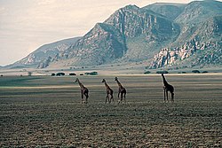
Malambo is a village in the Arusha Region of northern Tanzania, located near the Sanjan River, east of the Serengeti, west of Lake Natron, and north of Ngorongoro, in a picturesque but remote region. It is on the western edge of the Eastern Rift Valley, bordered by mountains on the west and a vast plain on the east.
Malambo has served as a home for many Maasai, and a rest stop for many more who pass through the region. It boasts a school, a medical clinic, a maternity clinic, and a small airstrip, though the village is still considered remote and impoverished. Because it is close to areas that are popular tourist safari attractions, visitors occasionally pass through.
Latang'amwaki Ndwati Mollel
Agbert Tajewo Mollel (Ngorongoro District)
Malambo' is a village in western Tanzania on the road between Sumbawanga, the capital of Rukwa Region, and Kigoma, the port city on the northern shore of Lake Tanganyika. It is on the western edge of Katavi National Park, a rarely visited park abundant with wildlife. This western area of Tanzania is remote with few tourist facilities and rarely visited by tourist safaris.
02°30′S35°36′E / 2.500°S 35.600°E
The Maasai are a Nilotic ethnic group inhabiting northern, central and southern Kenya and northern Tanzania, near the African Great Lakes region. Their native language is the Maasai language, a Nilotic language related to Dinka, Kalenjin and Nuer. Except for some elders living in rural areas, most Maasai people speak the official languages of Kenya and Tanzania—Swahili and English.
The Serengeti ecosystem is a geographical region in Africa, spanning the Mara and Arusha Regions of Tanzania. The protected area within the region includes approximately 30,000 km2 (12,000 sq mi) of land, including the Serengeti National Park and several game reserves. The Serengeti hosts the world's most massive land animal migration, which helps secure it as one of the Seven Natural Wonders of Africa.
Tanzania comprises many lakes, national parks, and Africa's highest point, Mount Kilimanjaro. Northeast Tanzania is mountainous, while the central area is part of a large plateau covered in grasslands. The country also contains the southern portion of Lake Victoria on its northern border with Uganda and Kenya.
The Serengeti National Park is a large national park in northern Tanzania that stretches over 14,763 km2 (5,700 sq mi). It is located in eastern Mara Region and northeastern Simiyu Region and contains over 1,500,000 ha of virgin savanna. The park was established in 1940.
Lake Manyara also known as Lake Moya among the Iraqw people is a lake located in Monduli District of Arusha Region, Tanzania and is the seventh-largest lake of Tanzania by surface area, at 470-square-kilometre (180 sq mi). It is a shallow, alkaline lake in the Natron-Manyara-Balangida branch of the East African Rift. The northwest quadrant of the lake is included within Lake Manyara National Park and it is part of the Lake Manyara Biosphere Reserve, established in 1981 by UNESCO as part of its Man and the Biosphere Programme.
Ngorongoro Conservation Area is a protected area and a UNESCO World Heritage Site located in Ngorongoro District, 180 km (110 mi) west of Arusha City in Arusha Region, within the Crater Highlands geological area of northeastern Tanzania. The area is named after Ngorongoro Crater, a large volcanic caldera within the area. The Ngorongoro Conservation Area Authority administers the conservation area, an arm of the Tanzanian government, and its boundaries follow the boundary of the Ngorongoro District in Arusha Region. The western portion of the park abuts the Serengeti National Park, and the area comprising the two parks and Kenya's Maasai Mara game reserve is home to Great Migration, a massive annual migration of millions of wildebeest, zebras, gazelles, and other animals. The conservation area also contains Olduvai Gorge, one of the most important paleoanthropological sites in the world.
Arusha Region is one of Tanzania's 31 administrative regions and is located in the northeast of the country. The region's capital and largest city is the city of Arusha. The region is bordered by Kajiado County and Narok County in Kenya to the north, the Kilimanjaro Region to the east, the Manyara and Singida Regions to the south, and the Mara and Simiyu regions to the west. Arusha Region is home to Ngorongoro Conservation Area, a UNESCO World Heritage Site. The region is comparable in size to the combined land and water areas of the state of Maryland in the United States.
Lake Manyara National Park is a protected area in Tanzania's Arusha and Manyara Regions, situated between Lake Manyara and the Great Rift Valley. It is administered by the Tanzania National Parks Authority, and covers an area of 325 km2 (125 sq mi) including about 230 km2 (89 sq mi) lake surface. More than 350 bird species have been observed on the lake.
Arusha National Park covers Mount Meru, a prominent volcano with an elevation of 4566 m, in the Arusha Region of north eastern Tanzania. The park is small but varied with spectacular landscapes in three distinct areas. In the west, the Meru Crater funnels the Jekukumia River; the peak of Mount Meru lies on its rim. Ngurdoto Crater in the south-east is grassland. The shallow alkaline Momella Lakes in the north-east have varying algal colours and are known for their wading birds.
Ngorongoro District is one of seven districts in western Arusha Region of Tanzania. The district is bordered to the north by Kenya, to the east by Monduli District, the northeast by Longido District, and to the south by the Karatu District. The western border is the Serengeti District in Mara Region. Ngorongoro District is home to the Ngorongoro Crater and was named after it. It covers an area of 14,036 km2 (5,419 sq mi). The district is comparable in size to the land area of Timor Leste. The administrative seat is the town of Loliondo. The district is home to the Ngorongoro Conservation Area which is a UNESCO World Heritage Site. The district is also home to the third tallest mountain in the country, Mount Loolmalasin. According to the 2002 Tanzania National Census, the population of the Ngorongoro Region was 129,776. By 2012, the population of the district was 174,278. By 2022, the population had grown to 273,549.
The Olduvai Gorge Museum is located in the Ngorongoro Conservation Area in Northern Tanzania on the edge of the Olduvai Gorge. The museum was founded by Mary Leakey and is now under the jurisdiction of the Tanzanian government's Department of Cultural Antiquities and is managed by the Ngorongoro Conservation Area Authority. It is a museum dedicated to the appreciation and understanding of the Olduvai Gorge and Laetoli fossil sites.
Mkomazi National Park is located in northeastern Tanzania on the Kenyan border, in Same District of Kilimanjaro Region and Lushoto District, with a slither of the park in Mkinga District both of Tanga Region. It was established as a game reserve in 1951 and upgraded to a national park in 2006.
The Crater Highlands or Ngorongoro Volcanic Highlands are a geological region along the East African Rift in the Arusha Region and parts of northern Manyara Region in north Tanzania. The Crater Highlands are made up of several large volcanic complexes, including the 2.4-2.2 Ma Lemagarut and 2.25-2.0 Ma Ngorongoro basalt-trachybasalt-trachyandesite volcanoes and the 1.6-1.5 Ma Oldeani basalt-trachyandesite volcano.
Tanzania is a country with many tourist attractions. Approximately 38 percent of Tanzania's land area is set aside in protected areas for conservation. There are 17 national parks, 29 game reserves, 40 controlled conservation areas and marine parks. Tanzania is also home to Mount Kilimanjaro, the highest point in Africa.
Mto wa Mbu is an administrative ward and town in the Monduli district of the Arusha Region of Tanzania. According to the 2012 census, the ward had a total population of 11,405. The name Mto wa Mbu means " The river of Mosquitoes " in the Swahili Language.
Karatu or Karatu Town is an administrative ward and district capital located in the Karatu District of the Arusha Region of Tanzania. The ward town is bordered on its north side by Ganako ward, to the east by Rhotia ward, to the south by Endamarariek ward, and to the west by Qurus ward. According to the 2012 census, the ward has a total population of 26,617. Karatu ward is the most populous ward in Karatu district and is the capital of Karatu District.
Magugu is an administrative ward in the Babati district of the Manyara Region of Tanzania. According to the 2002 census, the ward has a total population of 23,682. It is famous for its aromatic rice.
Mombasa Air Services, a Kenya air charter firm, was created when John Cleave purchased Rapid Air, a Civil Aviation Board licensed air charter firm with bases in Nyeri and Diani Beach. Flight operations were switched to the coast city of Mombasa, to serve the newly growing coast tourism industry and the company name was changed to Mombasa Air Services. During the seventies, eighties and nineties, Mombasa was restricted by existent colonial legislation, from receiving international scheduled services, which were all directed to the capital city of Nairobi. During the seventies and eighties, the Kenya coast was a recently discovered exotic tourism destination and direct charter flights from Europe grew rapidly and many new beach hotels were built to receive an increasing number of tourist arrivals from Europe.
Tanzania contains some 20 percent of the species of Africa's large mammal population, found across its reserves, conservation areas, marine parks, and 17 national parks, spread over an area of more than 42,000 square kilometres (16,000 sq mi) and forming approximately 38 percent of the country's territory. Wildlife resources of Tanzania are described as "without parallel in Africa" and "the prime game viewing country". Serengeti National Park, the country's second largest national park area at 14,763 square kilometres (5,700 sq mi), is located in northern Tanzania and is famous for its extensive migratory herds of wildebeests and zebra while also having the reputation as one of the great natural wonders of the world. The Ngorongoro Conservation Area, established in 1959, is a UNESCO World Heritage Site and inhabited by the Maasai people. Its Ngorongoro Crater is the largest intact caldera in the world.
The Southern Acacia–Commiphora bushlands and thickets is a tropical grasslands, savannas, and shrublands ecoregion in Tanzania and Kenya. It includes portions of Serengeti National Park and Ngorongoro Conservation Area, which are designated World Heritage Sites and biosphere reserves for their outstanding wildlife and landscapes. It is one of three Acacia–Commiphora bushlands and thickets ecoregions in eastern Africa.