A swimming pool, swimming bath, wading pool, paddling pool, or simply pool is a structure designed to hold water to enable swimming or other leisure activities. Pools can be built into the ground or built above ground, and are also a common feature aboard ocean-liners and cruise ships. In-ground pools are most commonly constructed from materials such as concrete, natural stone, metal, plastic, or fiberglass, and can be of a custom size and shape or built to a standardized size, the largest of which is the Olympic-size swimming pool.
Malanda is a rural town and locality in the Tablelands Region, Queensland, Australia. In the 2016 census, Malanda had a population of 1,985 people. The economy is based upon agriculture and tourism.
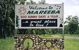
The Tablelands Region is a local government area in Far North Queensland, Australia inland from the city of Cairns. Established in 2008, it was preceded by four previous local government areas which dated back more than a century. On 1 January 2014, one of those local government areas, the Shire of Mareeba, was re-established independent of the Tablelands Region.
Malanda Falls Swimming Pool is located on the North Johnstone River in the Malanda Falls Park, adjacent to the Malanda Falls Conservation Park on the Atherton Tableland. First developed as a local recreation area during the early 20th century, Malanda Falls became associated with organised tourism on the Atherton Tableland from the 1920s and has been important in the development of the Cairns hinterland as a major tourist region in Queensland.[1]
The Johnstone River, comprising the North Johnstone River and the South Johnstone River, is a river system located in Far North and North Queensland, Australia.
Malanda Falls Conservation Park is located on the Malanda–Atherton Road, 1 km from Malanda, Queensland, on the Atherton Tableland, Australia.
The Atherton Tableland is a fertile plateau which is part of the Great Dividing Range in Queensland, Australia. The Atherton Tablelands is a diverse region, covering an area of 64,768 square kilometres and home to 45,243 people. The main population centres on the Atherton Tablelands are Mareeba and Atherton. Smaller towns include Tolga, Malanda, Herberton, Kuranda, Ravenshoe, Millaa Millaa, Chillagoe, Dimbulah, Mt Garnet, Mt Molloy, Tinaroo and Yungaburra.
Despite the focus of early settlers and investors on economic exploitation of the landscape on the Atherton Tableland, a number of tourist attractions emerged based on the very resources being exploited and were largely framed in Romantic terms. Early non-indigenous visitors to the Atherton Tableland were fascinated with waterfalls and their jungle backdrop, variously described and depicted as sublime, beautiful and picturesque. Timeless in their appeal, these natural features were and continue to be essential to the success of the region in attracting tourists.[1]
Romanticism was an artistic, literary, musical and intellectual movement that originated in Europe toward the end of the 18th century, and in most areas was at its peak in the approximate period from 1800 to 1850. Romanticism was characterized by its emphasis on emotion and individualism as well as glorification of all the past and nature, preferring the medieval rather than the classical. It was partly a reaction to the Industrial Revolution, the aristocratic social and political norms of the Age of Enlightenment, and the scientific rationalization of nature—all components of modernity. It was embodied most strongly in the visual arts, music, and literature, but had a major impact on historiography, education, the social sciences, and the natural sciences. It had a significant and complex effect on politics, with romantic thinkers influencing liberalism, radicalism, conservatism and nationalism.
Due to its proximity to the township of Malanda, the Falls have always been popular for local recreation and have been adapted over the last century to meet the needs of the local community and to enhance its beauty and bush surrounds as a tourist attraction.[1]
The Malanda Falls was surveyed in 1906 when it was described as being "partly covered with water lilies, and jungle stretched to the edge of the pool, with lots of fallen trees [in the] water". With the exception of the installation of hydraulic rams in 1911 to supply water to the Malanda Hotel and to steam trains, it would appear that the Falls remained undisturbed until 1918 when the local community cleared the underwater logs from the pool. The Falls quickly became a popular venue for New Year's Day picnic day celebrations and by 1920 the Eacham Shire Council had erected a substantial wooden diving platform and signs warning against nude bathing.[1]
The Shire of Eacham was a local government area of Queensland. It was located on the Atherton Tableland, a plateau forming part of the Great Dividing Range west of the city of Cairns. The shire, administered from the town of Malanda, covered an area of 1,126.4 square kilometres (434.9 sq mi), and existed as a local government entity from 1910 until 2008, when it amalgamated with several other councils in the Tableland area to become the Tablelands Region.
Eacham Shire Council sign, 2016
Other modifications included a wire netting fence erected around an unspecified area of the Malanda Falls Reserve in 1924, possibly to keep wandering animals from damaging the area. In 1925 when a retaining wall and a "narrow turning platform for swimmers, 25 yards from the bank" were built, Malanda's first swimming club was formed. Swimming carnivals were held between Malanda, Atherton, Mareeba and Cairns clubs in the pool until 1930. By 1934 the Malanda Swimming Club and the Eacham Shire Council had both contributed to and pool and surrounding reserve, with the Council's contribution amounting to £182/19/8 in 1933. The Department of Lands approved an additional advance of £50.00 for further enhancement works in 1934, and the Council engineer was instructed to look into building a path to the bottom of the Falls which was formed with terracing and gardens.[1]
Atherton is a rural town and locality on the Atherton Tablelands within the Tablelands Region, Far North Queensland, Australia. At the 2011 census, Atherton had a population of 7,287.
Mareeba is a rural town and locality in the Shire of Mareeba in Far North Queensland, Australia. The town is 417 metres (1,368 ft) above sea level on the confluence of the Barron River, Granite Creek and Emerald Creek. Between 2008 and 2013, it was within the Tablelands Region. The town's name is derived from an Aboriginal word meaning meeting of the waters. In the 2011 census, Mareeba had a population of 10,181 people.
The Australian pound was the currency of Australia from 1910 until 14 February 1966, when it was replaced by the Australian dollar. As with other £sd currencies, it was subdivided into 20 shillings, each of 12 pence.
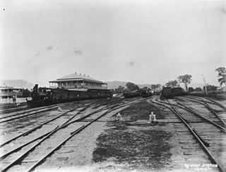
A significant feature of early tourism in the Cairns region was its use of the increasingly sophisticated transport infrastructure to service the mining, timber and agricultural industries. Development in Far North Queensland like other regions in Queensland was hampered by a lack of basic infrastructure. The construction of the Tablelands railway from Cairns to Mareeba provided for the development of the Barron Falls into one of the most popular tourist attractions in Queensland in the 1890s. Malanda Falls was also to benefit from this, when in 1910 the railway was extended to Malanda and a railway bridge erected spanning the Johnstone River just above the Falls allowing excursioners from other parts of the Atherton Tableland to visit the Falls more easily. It was not until the construction of the Gillies Highway in the 1920s that it became accessible to a greater number of people, notably tourists.[1]
Photographs of Malanda Falls appeared in tourism literature as early as 1920 and in 1925 the Falls were part of a day trip from either Herberton or Ravenshoe. This day trip was by car and also included on the itinerary were visits to Lake Barrine, Lake Eacham and Millaa Millaa Falls. Whitecars, a local hire-car service, commenced day tours of the southern Tableland c.1926 offered two tours to Malanda Falls: one including a visit to Glen Allyn Falls and the Malanda township, and the other incorporating a tour of the Malanda Butter Factory and The Jungle, an attraction which featured Aboriginal culture and the wonders of the rainforest.[1]
Established c.1922, Whitecars was integral to the development of tourism on the Tablelands and the increased popularity of region's attractions. Initially, Whitecars owners, Les Battle and Norm Graham, developed a timetabled taxi service between Malanda, Yungaburra and Atherton, and between Malanda and Millaa Millaa, with three cars. They took advantage of the 1926 opening of the Gillies Highway, linking the southern Tableland with Cairns, to take Ned Williams into partnership as The Cairns Tableland Motor Service Ltd to capitalise on the expected influx of tourists. In 1927 the company won the tender to transport passengers between Cairns and the southern Tableland via the Gillies Highway, and to operate day tours on the Tableland out of Yungaburra. In 1934 Whitecars introduced its first bus, capable of carrying 17 passengers to the area which, by this time, was being described in tourist guides featuring the Falls as "the land of waterfalls, cataracts and cascades".[1]
In the 1950s and 1960s, the Malanda Falls were included in the Grand Tour/Tropical Wonderland Tour itineraries promoted by the Queensland Government Tourist Bureau (by then part of Queensland Railways). The Grand Tour operated during the winter months when a P&O ship would arrive at Cairns each week from Melbourne and Brisbane carrying around 200 passengers for a six-day stay in the region. Upon arrival passengers could join the Tropical Wonderland Tour, which included being taken by White cars to visit the attractions of the Atherton Tableland, including not only the Malanda Falls but also the Millaa Millaa, Zillie and Glen Allyn Falls.[1]
From 1942 a large number of Australian and American troops were stationed on the Atherton Tablelands during World War II. Malanda Falls was a popular swimming and picnic spot for service personnel and during the war years Australian troops upgraded the pool at the base of the Falls and built a three level platform diving tower.[1]
As the tourism industry developed during the post war period, travel became easier and car ownership more commonplace and new tours were developed. Attractions such as Malanda Falls benefited from these changes and flourished. In 1961 a caravan park was established by the Eacham Shire Council, adjacent to the Falls with a capacity for 24 caravans, 30 camp sites and cabin accommodation for 20 people. Those staying at the caravan park inevitably visited the Falls and facilities were upgraded during the 1960s with the installation of a new concrete two-tiered diving platform along with a steel climbing frame allowing visitors to swing into the water, and grab rails and ladders to enter and leave the pool. In addition, the Malanda Swimming Club was reformed.[1]
Malanda Falls was prominent in travel literature until the 1970s and continues to be identified as a tourist destination. The welcoming ceremony of the "Malanda Monsoon Festival" is held at Malanda Falls where traditional owners the Ngadjon Jii people invite good spirits into the town. In addition a Waterfall Ceremony is held at dusk at the Falls which includes the lighting of lanterns beside the Johnstone River.[1]
Description
Malanda Falls Swimming Pool is located within the Malanda Falls Park, adjacent to the Malanda Falls Conservation Park, and is located on the western outskirts of Malanda on the Malanda-Atherton Road.[1]
Picnic shed, 2016
Rainforest lines the road and either side of the entrance to the reserve. Beside the highway are a series of picnic tables and barbeques and a colourful mosaic honouring the area's Aborigines for whom Malanda Falls has special significance. A large car park has been developed more recently developed along with a shelter shed and toilet block.[1]
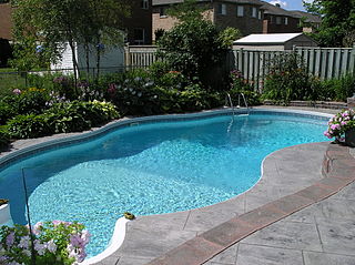
While the rainforest backdrop is a feature of and setting for the Falls, the river banks above the pool have been benched and mostly cleared of vegetation. The western side of the pool is highly structured with stone-walled terraces, manicured lawns, an extensive network of concrete paths, fences and steps and handrails. The terraces have three main levels that are constructed from coursed rubble stonework set in mortar with a concrete capping on top. The lower terrace has three additional concrete terraces and these are generally used as seating by visitors.[1]
Swimming pool and terraces, 2016
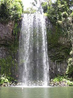
The Malanda Falls Scenic Reserve comprises the North Johnstone River flowing through dense rainforest and over the basalt rock of the Falls into a man-made swimming pool. The Falls has a height of about four metres and a width of approximately 30 metres (98ft). The long pool at its base is surrounded by concrete paths which provide easy and safe access to the pool and which allow visitors to cross the pool. At the base of the falls at the end of the concrete path on the western side, there is a metal sign affixed to the rock face with the image of a diver in red.[1]
The concrete bridge at the north end of the pool is approximately 30 metres (98ft) long. It leads to further concrete paths behind which a low coarse rubble retaining wall is located. Approximately halfway between the bridge and the Falls there are pool steps and a metal handrail attached to the concrete pathway. On the north eastern bank, steps with handrails lead to the Malanda Caravan Park. Further past these steps, towards the base of the Falls, are remnant concrete foundations, piping and the remains of a vertical boiler structure. The latter is riveted steel plate and is possibly associated with the water pumping activities of the Railways Department.[1]
Heritage listing
Malanda Falls Swimming Pool was listed on the Queensland Heritage Register on 5 February 2010 having satisfied the following criteria.[1]
The place is important in demonstrating the evolution or pattern of Queensland's history.
Malanda Falls Swimming Pool demonstrates the evolution of tourism in North Queensland as an important example of how the Far North has utilised the natural environment to promote tourism in the region. Initially a swimming hole for locals, improvements to the site, such as terracing and gardens, transformed Malanda Falls from a natural waterhole to a more structured recreation area and swimming pool and since the 1930s has been a popular tourist destination.[1]
The place is important because of its aesthetic significance.
Malanda Falls Swimming Pool is valued for its aesthetic qualities and has been recognised in tourism photographs and literature since the 1920s as a picturesque destination that forms part of Far North Queensland's waterfall and picnic circuit. The manicured swimming hole is surrounded by terraced gardens and dense rainforest. Water tumbles over a basalt rock face into a structured pool below, evoking a strong sense of tranquillity and peace.[1]
Related Research Articles
Yungaburra is a town located on the Atherton Tableland in Far North Queensland, Australia, not far from Cairns. In the 2011 census, Yungaburra had a population of 1,116 people.
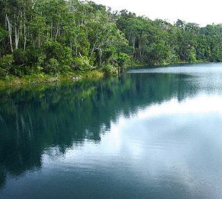
Lake Eacham is a popular lake of volcanic origin on the Atherton Tableland of Queensland, Australia, within the World Heritage listed Wet Tropics of Queensland. It is within the locality of Lake Eacham in the Tablelands Region local government area.
The Barron Falls is a steep tiered cascade waterfall on the Barron River located where the river descends from the Atherton Tablelands to the Cairns coastal plain, in Queensland, Australia.
The Palmerston Highway, serves as a link between the southern part of the Atherton Tablelands and the Far North Queensland coastal strip, in Australia. Starting just north of Innisfail, from the Bruce Highway it winds through the Wooroonooran National Park to the township of Millaa Millaa, with no major road junctions. It terminates at an intersection with Old Palmerston Highway and Main Street. Its total length is 54.6 kilometres. From here State Route 25 continues west and then north as Malanda-Millaa Millaa Road, while Old Palmerston Highway continues south and then west as a Tourist Drive to where it meets the Kennedy Highway north of Ravenshoe.
Curtain Fig Tree is a heritage-listed tree at Curtain Fig Tree Road, Yungaburra, Tablelands Region, Queensland, Australia. It is one of the largest trees in Tropical North Queensland, Australia, and one of the best known attractions on the Atherton Tableland. It was added to the Queensland Heritage Register on 3 December 2009.
Millaa Millaa Falls is a heritage-listed plunge waterfall at Theresa Creek Road, Millaa Millaa, Tablelands Region, Queensland, Australia. It was added to the Queensland Heritage Register on 5 December 2005.
The Cairns District Rugby League was formed on 5 August 1918 and is the administrative body for the game of rugby league football in Cairns, Queensland. The CDRL runs senior, junior and women's club competitions and has its headquarters at Barlow Park.
The Tablelands line is a railway line in North Queensland, Australia. It was opened in a series of sections between 1887 and 1916. It commences at Cairns and at its maximum extent, reached Ravenshoe at the southern end of the Atherton Tableland. The rail system served by this line was unusual for Queensland in that the majority of lines that connected to it were built by private companies and later purchased by the Queensland Government.
Majestic Picture Theatre is a heritage-listed theatre at 1 Eacham Place, Malanda, Tablelands Region, Queensland, Australia. It was designed by Bob Hassall and built in 1929 by Albie Halfpapp. It is also known as Majestic Theatre. It was added to the Queensland Heritage Register on 5 February 2010.
Lake Eacham Hotel is a heritage-listed hotel at 6-8 Kehoe Place, Yungaburra, Tablelands Region, Queensland, Australia. It was built in 1910 by Side Brothers. It was added to the Queensland Heritage Register on 21 October 1992.
Cairns Plywood Pty Ltd Sawmill Complex is a heritage-listed sawmill at 25 - 33 Eacham Road, Yungaburra, Tablelands Region, Queensland, Australia. It was built from 1910 to 1980s. It is also known as Cairns Plywood Limited, Eacham Sawmills, and Williamson Brothers Sawmill. It was added to the Queensland Heritage Register on 21 October 1992.
The Ngajanji, also written Ngadyan, are an Indigenous Australian people of the rainforest region south of Cairns, in northern Queensland. They form one of 8 groups, the others being Yidin, Mamu, Dyirbal, Girramay, Warrgamay, Waruŋu and Mbabaram, of the Dyirbal tribes.
The Ellinjaa Falls is a ledge waterfall that is located on Ellinjaa Creek, on the Atherton Tableland in the North region of Queensland, Australia.
Lake Barrine is a rural locality in the Tablelands Region, Queensland, Australia. In the 2016 census, Lake Barrine had a population of 152 people.
This page is based on this Wikipedia article Text is available under the CC BY-SA 4.0 license; additional terms may apply. Images, videos and audio are available under their respective licenses.