Petra, originally known to its inhabitants as Raqmu, is a historic and archaeological city in southern Jordan. Famous for its rock-cut architecture and water conduit systems, Petra is also called the "Rose City" because of the colour of the sandstone from which it is carved. The city is one of the New 7 Wonders of the World and a UNESCO World Heritage Site.

The Negev or Negeb is a desert and semidesert region of southern Israel. The region's largest city and administrative capital is Beersheba, in the north. At its southern end is the Gulf of Aqaba and the resort city and port of Eilat. It contains several development towns, including Dimona, Arad, and Mitzpe Ramon, as well as a number of small Bedouin towns, including Rahat, Tel Sheva, and Lakiya. There are also several kibbutzim, including Revivim and Sde Boker; the latter became the home of Israel's first Prime Minister, David Ben-Gurion, after his retirement from politics.

Shivta, originally Sobata or Subeita, is an ancient city in the Negev Desert of Israel located 43 kilometers southwest of Beersheba. Shivta was declared a UNESCO World Heritage Site in June 2005, as part of the Incense Route and the Desert Cities of the Negev, together with Haluza/Elusa, Avdat and Mamshit/Mampsis.
Golan is the name of a biblical town later known from the works of Josephus and Eusebius. Archaeologists localize the biblical city of Golan at Sahm el-Jaulān, a Syrian village east of Wadi ar-Ruqqad in the Daraa Governorate, where early Byzantine ruins were found. Israeli historical geographer, Zev Vilnay, tentatively identified the town Golan with the Goblana (Gaulan) of the Talmud which he thought to be the ruin ej-Jelêbîne on the Wâdy Dabûra, near the Lake of Huleh, by way of a corruption of the site's original name.

Tel Dor or Tell el-Burj, also Khirbet el-Burj in Arabic, is an archaeological site located on the Israeli coastal plain of the Mediterranean Sea next to modern moshav Dor, about 30 kilometers (19 mi) south of Haifa, and 2.5 kilometers (1.6 mi) west of Hadera. Lying on a small headland at the north side of a protected inlet, it is identified with D-jr of Egyptian sources, Biblical Dor, and with Dor/Dora of Greek and Roman sources.

The archaeology of Israel is the study of the archaeology of the present-day Israel, stretching from prehistory through three millennia of documented history. The ancient Land of Israel was a geographical bridge between the political and cultural centers of Mesopotamia and Egypt.
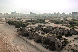
Ashdod-Yam or Azotus Paralios is an archaeological site on the Mediterranean coast of Israel. It is located in the southern part of the modern city of Ashdod, and about 5 kilometres northwest of the ancient site of Tel Ashdod, where ancient Ashdod stood in the time of the Philistines. Ashdod-Yam and its inland counterpart, Ashdod or Azotus Mesogaios, were for most of their history two closely connected but distinct entities. Much of the surrounding environ is covered by sand dunes and remains unexplored.
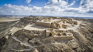
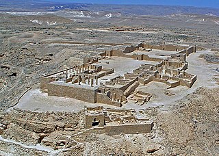
Avdat or Ovdat, and Abdah or Abde, are the modern names of an archaeological site corresponding to the ancient Nabataean, Roman and Byzantine settlement of Oboda or Eboda in the Negev desert in southern Israel. It was inhabited with intermissions between the 3rd century BCE and the mid-7th century CE by Nabataeans, in their time becoming the most important city on the Incense Route after Petra, then by Roman army veterans, and Byzantines, surviving only for a few years into the Early Muslim period. Avdat was a seasonal camping ground for Nabataean caravans travelling along the early Petra–Gaza road in the 3rd – late 2nd century BCE. The city's original name was changed in honor of Nabataean King Obodas I, who, according to tradition, was revered as a deity and was buried there.

Ir Ovot is a small village in southern Israel. Located in the northeastern Arabah, it falls under the jurisdiction of Central Arava Regional Council. It operated as a kibbutz from 1967 until the 1980s. In 2019 it had a population of 54.

Maresha was an Iron Age city mentioned in the Hebrew Bible, whose remains have been excavated at Tell Sandahanna, an archaeological mound or 'tell' renamed after its identification to Tel Maresha. The ancient Judahite city became Idumaean after the fall of Judah in 586 BCE, and after Alexander's conquest of the region in 332 BCE became Hellenised under the name Marisa or Marissa. The tell is situated in Israel's Shephelah region, i.e. in the foothills of the Judaean Mountains, about 1.5 kilometres (0.93 mi) south of Beit Gubrin.
The ancient city of Halasa or Chellous, Elusa (Ελουϲα) in the Byzantine period, was a city in the Negev near present-day Kibbutz Mash'abei Sadeh that was once part of the Nabataean Incense Route. It lay on the route from Petra to Gaza. Today it is known as Haluza, and during periods of Arab habitation it was known as al-Khalūṣ and Al-Khalasa.
Incense Route – Desert Cities in the Negev is a World Heritage-designated area near the end of the Incense Route in the Negev, southern Israel, which connected Arabia to the Mediterranean in the Hellenistic-Roman period, proclaimed as being of outstanding universal value by UNESCO in 2005. The trade led to the development of ancient towns, forts and caravanserai en route, apart from agricultural development.

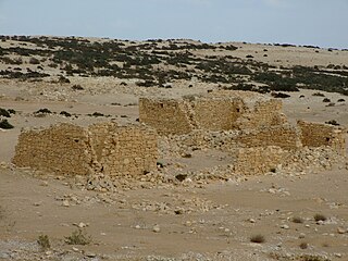
Nessana, Modern Hebrew name Nizzana, also spelled Nitzana, is an ancient Nabataean city located in the southwest Negev desert in Israel close to the Egyptian border. It started by being a caravan station on the ancient Incense Road, protecting a western branch of the road which allowed access to Egypt to the west via the Sinai, and to Beersheba, Hebron and Jerusalem to the northeast. It was first used by Nabataean merchants, and later also by Christian pilgrims.
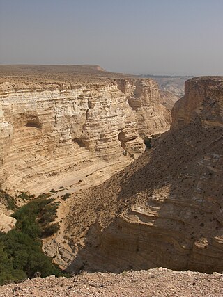
Ein Avdat or Ein Ovdat is a canyon in the Negev Desert of Israel, south of Kibbutz Sde Boker. Archaeological evidence shows that Ein Avdat was inhabited by Nabateans and Catholic monks. Numerous springs at the southern opening of the canyon empty into deep pools in a series of waterfalls. The water emerges from the rock layers with salt-tolerant plants like Poplar trees and Atriplexes growing nearby.
The Monastery of St Lot is a Byzantine-period monastic site near the Dead Sea in Jordan, at the entrance to a natural cave, which Christians believed to have been the one where Lot and his daughters sought shelter after Sodom was destroyed. The monastery, dating to the 5th-7th centuries, is centered around a basilical church and overlooks from a steep slope the southeastern Dead Sea and the modern town of Safi in Jordan.
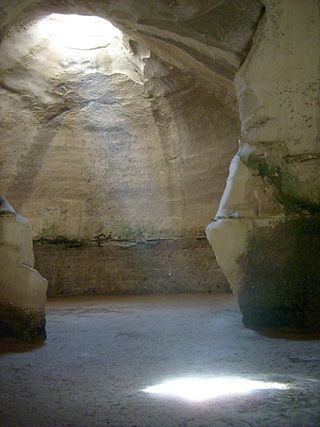
Beit Guvrin-Maresha National Park is a national park in central Israel, containing a large network of caves recognized by UNESCO as a World Heritage Site. The national park includes the remains of the historical towns of Maresha, one of the important towns of Judah during the First Temple Period, and Bayt Jibrin, a depopulated Palestinian town known as Eleutheropolis in the Roman era. However, Maresha and Bayt Jibrin are not part of the UNESCO site, which covers only the cave network.

Nabatean architecture refers to the building traditions of the Nabateans, an ancient Arab people who inhabited northern Arabia and the southern Levant. Their settlements—most prominently the assumed capital city of Raqmu —gave the name Nabatene to the Arabian borderland that stretched from the Euphrates to the Red Sea. Their architectural style is notable for its temples and tombs, most famously the ones found in Petra. The style appears to be a mix of Mesopotamian, Phoenician, Hellenisticn, and South Arabian influences modified to suit the Arab architectural taste. Petra, the capital of the kingdom of Nabatea, is as famous now as it was in the antiquity for its remarkable rock-cut tombs and temples. Most architectural Nabatean remains, dating from the 1st century BC to the 2nd century AD, are highly visible and well-preserved, with over 500 monuments in Petra, in modern-day Jordan, and 110 well preserved tombs set in the desert landscape of Hegra, now in modern-day Saudi Arabia. Much of the surviving architecture was carved out of rock cliffs, hence the columns do not actually support anything but are used for purely ornamental purposes. In addition to the most famous sites in Petra, there are also Nabatean complexes at Obodas (Avdat) and residential complexes at Mampsis (Kurnub) and a religious site of et-Tannur.

Avraham Negev (1923–2004) was an Israeli archaeologist.

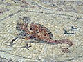
Ein Gedi was an important Jewish settlement on the western shore of the Dead Sea in ancient times. The ruins, including the 6th century Ein Gedi synagogue, home to one of the most impressive mosaic floors in Israel, testify to a continuous Jewish settlement in the area for over 1,300 years, from the 7th century BCE to the 6th century CE.
The Negev region, situated in the southern part of present-day Israel, has a long and varied history that spans thousands of years. Despite being predominantly a semi-desert or desert, it has historically almost continually been used as farmland, pastureland, and an economically significant transit area.